Category:Inistioge
Jump to navigation
Jump to search
village in County Kilkenny, Ireland  | |||||
| Upload media | |||||
| Instance of | |||||
|---|---|---|---|---|---|
| Location | County Kilkenny, Leinster, Ireland | ||||
 | |||||
Subcategories
This category has the following 10 subcategories, out of 10 total.
B
- Black Castle, Inistioge (4 F)
I
- Inistioge Bridge (9 F)
- Inistioge Priory (1 F)
- Inistioge village green (9 F)
S
- St. Mary's Church, Inistioge (9 F)
T
- Tighe Mausoleum (2 F)
W
- Woodstock Arms, Inistioge (4 F)
Media in category "Inistioge"
The following 107 files are in this category, out of 107 total.
-
 AA and RIAC town sign, Inistioge - geograph.org.uk - 4453527.jpg 2,000 × 1,964; 637 KB
-
 Ballycocksoost Junction - geograph.org.uk - 2768683.jpg 600 × 450; 253 KB
-
 Blooming Wisteria - geograph.org.uk - 5365940.jpg 640 × 480; 155 KB
-
 Bog Asphodel - geograph.org.uk - 5852084.jpg 600 × 800; 257 KB
-
 Bridge and Stream - geograph.org.uk - 6419251.jpg 655 × 490; 166 KB
-
 Café and Millennium sundial, Inistioge - geograph.org.uk - 4453533.jpg 2,000 × 1,480; 1,002 KB
-
 Carrigeen Lane - geograph.org.uk - 2053512.jpg 600 × 400; 97 KB
-
 Cloudscape and Track - geograph.org.uk - 5852080.jpg 800 × 600; 75 KB
-
 Cold Sheep - geograph.org.uk - 5655085.jpg 640 × 426; 130 KB
-
 Commemorative plaque for Fren(e)y the Robber.jpg 2,736 × 1,941; 1.13 MB
-
 Contented Ewe - geograph.org.uk - 5312216.jpg 480 × 640; 144 KB
-
 Cottage at Old Court - geograph.org.uk - 2053509.jpg 600 × 400; 91 KB
-
 Cottage ^ Flags - geograph.org.uk - 2054092.jpg 600 × 400; 88 KB
-
 Country Lane - geograph.org.uk - 3011374.jpg 600 × 450; 289 KB
-
 Country Lane - geograph.org.uk - 4839648.jpg 600 × 450; 355 KB
-
 Country Lane - geograph.org.uk - 4839652.jpg 600 × 450; 290 KB
-
 Cut leaf Beech at Woodstock - geograph.org.uk - 6023820.jpg 2,159 × 2,879; 2.5 MB
-
 Daffodils and Water Pump - geograph.org.uk - 5312224.jpg 480 × 640; 122 KB
-
 Farm Building ^ Bales - geograph.org.uk - 2053491.jpg 600 × 400; 99 KB
-
 Farm Road - geograph.org.uk - 2053443.jpg 600 × 400; 343 KB
-
 Flower Island - geograph.org.uk - 5365912.jpg 640 × 480; 182 KB
-
 Flowerpot Boot - geograph.org.uk - 4171564.jpg 600 × 450; 106 KB
-
 Flowers in the walled garden, Woodstock - geograph.org.uk - 4453136.jpg 2,000 × 1,500; 1.69 MB
-
 Forest and Track - geograph.org.uk - 5161809.jpg 640 × 480; 97 KB
-
 Forest Edge - geograph.org.uk - 4877480.jpg 600 × 450; 266 KB
-
 Forest Gateway - geograph.org.uk - 2051044.jpg 600 × 400; 99 KB
-
 Forest Track - geograph.org.uk - 4839659.jpg 600 × 450; 325 KB
-
 Forest track on Mt Alto near Inistioge, Co Kilkenny - geograph.org.uk - 6375526.jpg 1,799 × 1,199; 410 KB
-
 Forest ^ Hillside - geograph.org.uk - 2053104.jpg 600 × 400; 88 KB
-
 Forested Hillside - geograph.org.uk - 2051052.jpg 600 × 400; 85 KB
-
 Forestry Track - geograph.org.uk - 2053119.jpg 600 × 400; 77 KB
-
 Four Green Fields - geograph.org.uk - 6303785.jpg 800 × 600; 212 KB
-
 Garden Gate - geograph.org.uk - 6039809.jpg 800 × 600; 146 KB
-
 Gate ^ Field - geograph.org.uk - 2053473.jpg 600 × 400; 91 KB
-
 Gate ^ Fields - geograph.org.uk - 2053449.jpg 600 × 400; 75 KB
-
 Gate ^ Waymarker - geograph.org.uk - 2053483.jpg 600 × 400; 96 KB
-
 Gnarled Oak - geograph.org.uk - 4941926.jpg 480 × 640; 145 KB
-
 Happiness Is - geograph.org.uk - 5312218.jpg 640 × 427; 92 KB
-
 House and Entrance - geograph.org.uk - 2053493.jpg 600 × 400; 101 KB
-
 Houseboat on the Nore - geograph.org.uk - 1992959.jpg 600 × 400; 54 KB
-
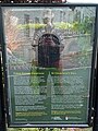 Information board for St Colmcille's Well.jpg 2,016 × 2,685; 991 KB
-
 Inistioge - Old AA sign - geograph.org.uk - 6502584.jpg 1,799 × 1,199; 321 KB
-
 Inistioge - Woodstock Arms - geograph.org.uk - 6502580.jpg 1,799 × 1,199; 320 KB
-
 Inistioge and River Nore - geograph.org.uk - 5737528.jpg 640 × 480; 110 KB
-
 Inistioge courthouse.jpg 2,016 × 4,032; 3.78 MB
-
 Inistioge from Sandford Castle - geograph.org.uk - 488492.jpg 640 × 512; 118 KB
-
 Inistioge Stained Glass - geograph.org.uk - 5365944.jpg 640 × 480; 91 KB
-
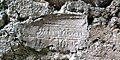 Inscription in plaster.jpg 4,032 × 2,016; 3.78 MB
-
 Island in the Nore - geograph.org.uk - 4941875.jpg 600 × 450; 338 KB
-
 Island View, near Inistioge, Co.Kilkenny - geograph.org.uk - 213448.jpg 480 × 640; 111 KB
-
 Junction and Signposts - geograph.org.uk - 2054155.jpg 600 × 400; 100 KB
-
 Junction ^ Signposts - geograph.org.uk - 2054130.jpg 600 × 400; 86 KB
-
 Kilkenny Landscape - geograph.org.uk - 3011382.jpg 600 × 450; 291 KB
-
 Knox's Bower - geograph.org.uk - 5737751.jpg 640 × 480; 212 KB
-
 Lodge at River Gate.jpg 4,032 × 2,016; 2.94 MB
-
 Maker's mark Kelly and Son in Inistioge.jpg 3,104 × 3,104; 3.1 MB
-
 Methodist Hall, Inistioge - geograph.org.uk - 1539704.jpg 640 × 480; 72 KB
-
 Monkey Puzzle - geograph.org.uk - 6066206.jpg 600 × 800; 571 KB
-
 Noble Fir Walk - geograph.org.uk - 6066194.jpg 600 × 800; 520 KB
-
 Nore Bridge - geograph.org.uk - 6040231.jpg 800 × 600; 131 KB
-
 O'Donnell's pub - geograph.org.uk - 838227.jpg 640 × 396; 69 KB
-
 Ogham Stone - geograph.org.uk - 773449.jpg 427 × 640; 78 KB
-
 Ogham stone - geograph.org.uk - 773455.jpg 640 × 427; 71 KB
-

-
 Old Farm Buildings - geograph.org.uk - 2053501.jpg 600 × 400; 83 KB
-
 Old hikers never die... - geograph.org.uk - 4171560.jpg 600 × 373; 112 KB
-
 Open Space - geograph.org.uk - 6067561.jpg 800 × 600; 478 KB
-
 Picnic Table and River - geograph.org.uk - 4941859.jpg 600 × 450; 302 KB
-
 Plant Entrance - geograph.org.uk - 5601656.jpg 640 × 480; 105 KB
-
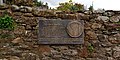 Plaque for George Brown.jpg 4,032 × 2,016; 3.78 MB
-
 Plaster Model of Mary Tighe Rothe House.jpg 2,000 × 1,392; 1.52 MB
-
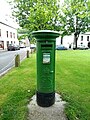 Post box in Inistioge.jpg 3,120 × 4,160; 6.73 MB
-
 Red Tank - geograph.org.uk - 5601628.jpg 640 × 476; 107 KB
-
 River bank at Inistioge - geograph.org.uk - 838236.jpg 640 × 395; 51 KB
-
 Road Junction - geograph.org.uk - 2054174.jpg 600 × 400; 78 KB
-
 Road Junction - geograph.org.uk - 2054391.jpg 600 × 400; 90 KB
-
 Road Junction at Coolshanvogh - geograph.org.uk - 2768696.jpg 600 × 450; 246 KB
-
 Roadside Fuchsia - geograph.org.uk - 2054109.jpg 600 × 400; 116 KB
-
 Rough Track - geograph.org.uk - 5161814.jpg 640 × 480; 142 KB
-
 Rural Settlement - geograph.org.uk - 5601623.jpg 640 × 480; 90 KB
-
 Seat and Conservatory - geograph.org.uk - 6039805.jpg 800 × 600; 211 KB
-
 Shed and Spreader - geograph.org.uk - 4877504.jpg 600 × 450; 179 KB
-
 Sheep and Twins - geograph.org.uk - 4839727.jpg 600 × 450; 270 KB
-
 Slipway on River Nore - geograph.org.uk - 4941870.jpg 600 × 450; 308 KB
-
 Sloping wall - geograph.org.uk - 6039801.jpg 800 × 600; 247 KB
-
 Solar Powered Pump - geograph.org.uk - 4877507.jpg 600 × 450; 231 KB
-
 South Kilkenny Landscape - geograph.org.uk - 4941915.jpg 640 × 480; 78 KB
-
 Speckled Wood - geograph.org.uk - 2053485.jpg 600 × 459; 62 KB
-
 Sports Field - geograph.org.uk - 6419270.jpg 800 × 600; 212 KB
-
 Stonework Detail - geograph.org.uk - 4941848.jpg 600 × 450; 383 KB
-
 Stream running through Inistioge.jpg 2,016 × 4,032; 4.34 MB
-
 Street name sign Mill Road in Inistioge.jpg 4,032 × 2,016; 4.07 MB
-
 The post office, Inistioge - geograph.org.uk - 4453535.jpg 2,000 × 1,484; 1.02 MB
-

-
 Track and Hillside - geograph.org.uk - 4839663.jpg 600 × 450; 303 KB
-
 Tree and Wall - geograph.org.uk - 5655079.jpg 640 × 480; 158 KB
-
 View NE to Inistioge ^ R Nore, Co Kilkenny - geograph.org.uk - 6375529.jpg 1,799 × 1,199; 364 KB
-
 Village Square at Inistioge, Co Kilkenny - geograph.org.uk - 6375531.jpg 1,799 × 1,199; 384 KB
-
 Walled Garden - geograph.org.uk - 5737739.jpg 640 × 426; 135 KB
-
 Water Plant Entrance - geograph.org.uk - 4877484.jpg 600 × 450; 194 KB
-
 White Cottage - geograph.org.uk - 2053492.jpg 600 × 400; 86 KB
-
 Whitethorn and Wall - geograph.org.uk - 3007181.jpg 600 × 800; 533 KB
-
 Wild Orchid - geograph.org.uk - 5852087.jpg 600 × 800; 316 KB
-
 Woodland Flowers - geograph.org.uk - 5365920.jpg 640 × 480; 203 KB
-
 Woodland Wall - geograph.org.uk - 6039793.jpg 800 × 600; 231 KB
-
 Woodland Waterfall - geograph.org.uk - 6419256.jpg 600 × 800; 440 KB
-
 Young Forest - geograph.org.uk - 6067569.jpg 800 × 600; 531 KB


y_the_Robber.jpg)


