Category:Inglewhite
Jump to navigation
Jump to search
English: Inglewhite is a small village in the parish of Goosnargh in Lancashire, England. It lies at the intersection of the roads from Longridge to Garstang and from Broughton to Beacon Fell. (→Inglewhite)
Polski: Inglewhite – wieś w Anglii, w hrabstwie Lancashire, w dystrykcie Preston. Leży 53 km na północny zachód od miasta Manchester i 313 km na północny zachód od Londynu. (→Inglewhite)
village in Lancashire, England, UK  | |||||
| Upload media | |||||
| Instance of | |||||
|---|---|---|---|---|---|
| Location | Goosnargh, Preston, Lancashire, North West England, England | ||||
 | |||||
Subcategories
This category has the following 2 subcategories, out of 2 total.
G
- The Green Man at Inglewhite (4 F)
I
Media in category "Inglewhite"
The following 20 files are in this category, out of 20 total.
-
 Arriving at Inglewhite - geograph.org.uk - 2469673.jpg 4,000 × 3,000; 6.6 MB
-
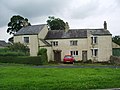 Black Bull Farm and Cottage, Inglewhite - geograph.org.uk - 912058.jpg 640 × 480; 166 KB
-
 Black Bull Farm, Inglewhite, Doorway - geograph.org.uk - 912060.jpg 480 × 640; 163 KB
-
 Bluebell Path,Walmsley Bridge - geograph.org.uk - 699987.jpg 480 × 640; 157 KB
-
 Inglewhite Green - geograph.org.uk - 3277785.jpg 2,560 × 1,920; 2.45 MB
-
 Inglewhite Green - geograph.org.uk - 47149.jpg 640 × 480; 70 KB
-
 Inglewhite Road about to enter Inglewhite - geograph.org.uk - 2385367.jpg 1,024 × 744; 96 KB
-
 Inglewhite village entrance sign - geograph.org.uk - 2848815.jpg 640 × 481; 74 KB
-
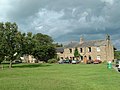
 Inglewhite village green - geograph.org.uk - 818743.jpg 600 × 439; 55 KB
-
 Inglewhite village green - geograph.org.uk - 912063.jpg 640 × 480; 157 KB
-
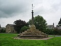 Memorial - geograph.org.uk - 912055.jpg 640 × 480; 151 KB
-
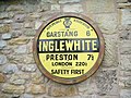
 Old AA distance sign - geograph.org.uk - 2843173.jpg 1,600 × 1,200; 437 KB
-
 Road junction Inglewhite Village Green - geograph.org.uk - 2311022.jpg 640 × 426; 225 KB
-
 Sign, Inglewhite - geograph.org.uk - 912065.jpg 640 × 480; 190 KB
-
 The view when sitting on the village green at Inglewhite - geograph.org.uk - 4153212.jpg 4,592 × 3,056; 7.22 MB
-
 Bluebells - geograph.org.uk - 415794.jpg 500 × 335; 319 KB
-
 Cowfield - geograph.org.uk - 46803.jpg 640 × 397; 74 KB
-
 Lane nr Lower Barker - geograph.org.uk - 47147.jpg 640 × 480; 77 KB
-
 Nr Lower Barker - geograph.org.uk - 47144.jpg 640 × 480; 102 KB
-
 Road Junction near Inglewhite - geograph.org.uk - 113175.jpg 640 × 480; 110 KB


