Category:Information boards in Velbert
Jump to navigation
Jump to search
Kreis Mettmann  Erkrath · Haan · Heiligenhaus · Langenfeld · Mettmann · Ratingen · Velbert · Wülfrath ·
Subcategories
This category has the following 4 subcategories, out of 4 total.
Media in category "Information boards in Velbert"
The following 26 files are in this category, out of 26 total.
-
 Karte Bergisch Märkisches Erholungsgebiet Rundwege Deilbachtal.jpg 4,320 × 3,240; 4.37 MB
-
 Karte „Naturlehrpfad Velbert-Langenberg“.jpg 4,320 × 3,240; 4.73 MB
-
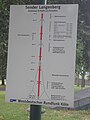
 Karte „Rundwanderwege Huxel, Langenberger Sender“.jpg 4,320 × 3,240; 4.67 MB
-
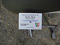
 Plan des Sendemastes Hordtberg.JPG 2,448 × 3,264; 2.09 MB
-
 Velbert, Herminghauspark, Parkwegweiser.jpg 2,530 × 1,750; 3.25 MB
-
 Velbert, Nevigeser Str. 1, Friedenskirche, Aushangkasten.jpg 2,386 × 2,539; 1.23 MB
-

-
-

-
 Velbert, Westende Asbachtal, Kruppsche Nachtscheinanlage, Einmann-Bunker, Info-Tafel.jpg 2,540 × 3,387; 1.96 MB
-

-
-

-

-

-
-
 Velbert, Westende Asbachtal, Kruppsche Nachtscheinanlage, Sheddach-Attrappe, Info-Tafel.jpg 2,477 × 3,301; 1.57 MB
-
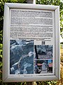
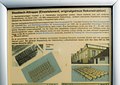
 Velbert-Langenberg, Gutsweg 2, Ostseite, Banner mit Restaurierungs-Informationen, Bild 1.jpg 3,254 × 2,515; 1.81 MB
-

-

-

-
 Velbert-Langenberg, Voßkuhlstr. 57, Hausnummernschilder.jpg 3,182 × 2,616; 1.97 MB
-
 Velbert-Neviges, Kreuzberg, Info-Tafel mit allg.Gefahrenhinweis.jpg 1,789 × 2,386; 1.03 MB
-

-

-
 Velbert-Neviges, Weinbergstr. 12, Eingangstür, Info-Zettel.jpg 2,838 × 2,128; 1,013 KB


,_Eingang,_Info-Zettel_mit_Hinweis_auf_%27Gef%C3%A4hrdungsb%C3%A4ume%27.jpg)
,_Info-Zettel_%27Corona-Regeln%27,_an_Baum_auf_Versammlungsplatz_vor_Marienkapelle_gepinnt.jpg)
