Category:Information boards in Reinhardswald
Jump to navigation
Jump to search
Subcategories
This category has the following 2 subcategories, out of 2 total.
Media in category "Information boards in Reinhardswald"
The following 68 files are in this category, out of 68 total.
-
 041 PanoramaHolzhausen.jpg 17,392 × 4,548; 12.15 MB
-
 072 Informationsschild zur Schmierkohle und der Farbe Kasselerbraun.jpg 4,032 × 3,024; 2.78 MB
-

-
 1118 Informationstafel zum ehemligen Basaltsteinbruch auf dem Westberg.jpg 9,248 × 6,936; 8.61 MB
-
 1119 Informationstafel zum ehemligen Basaltsteinbruch auf dem Westberg.jpg 9,248 × 6,936; 8.56 MB
-
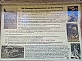
 125 Informationsschild zu den Zechen am Osterberg.jpg 4,032 × 3,024; 3.34 MB
-
 127 Informationsschild zu den Zechen am Osterberg.jpg 9,248 × 6,936; 9.84 MB
-
 128 Informationsschild zu den Zechen am Osterberg.jpg 9,248 × 6,936; 9.08 MB
-
 147 Braunkohlebergbau am Ahlberg.jpg 9,248 × 6,936; 9.17 MB
-
 148 Braunkohlebergbau am Ahlberg.jpg 9,248 × 6,936; 9.12 MB
-
 170 Informatiostafel "Die Fichtenklumpse".jpg 6,936 × 9,248; 14.66 MB
-
 171 Fichtenklumpse.jpg 6,936 × 9,248; 23.04 MB
-
 173 Informatiostafel "Die Fichtenklumpse".jpg 9,248 × 6,936; 22.45 MB
-
 174 Informatiostafel "Die Fichtenklumpse".jpg 6,936 × 9,248; 21.72 MB
-
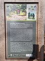
 364 Informationstafel zur Zeche Garenberg.jpg 9,248 × 6,936; 10.85 MB
-
 365 Informationstafel zur Zeche Garenberg.jpg 9,248 × 6,936; 9.23 MB
-
 366 Informationstafel zur Zeche Garenberg.jpg 6,936 × 9,248; 8.97 MB
-
 367 Informationstafel zur Zeche Garenberg.jpg 6,936 × 9,248; 8.73 MB
-
 368 Informationstafel zur Zeche Garenberg.jpg 9,248 × 6,936; 10.67 MB
-
 368 Märchenlandweg - wie der Reinhardswald entstanden ist und seinen Namen bekam.jpg 9,248 × 6,936; 7.91 MB
-
 369 Informationstafel zur Zeche Garenberg.jpg 9,248 × 6,936; 11.67 MB
-
 370 Informationstafel zur Zeche Garenberg.jpg 9,248 × 6,936; 11.3 MB
-
 371 Informationstafel zur Zeche Garenberg.jpg 6,936 × 9,248; 9.07 MB
-
 372 Informationstafel zur Zeche Garenberg.jpg 384 × 512; 54 KB
-
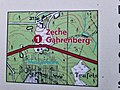
 383 Wanderkarte - Ausgangspunkt Eco Pfad Bergbau Holzhausen Reinhardswald.jpg 9,248 × 6,936; 9.56 MB
-
 445 Informationstafel Alaunteich.jpg 9,248 × 6,936; 10.41 MB
-
 446 Informationstafel Alaunteich.jpg 9,248 × 6,936; 10.36 MB
-
 449 Informationstafel Zeche Wilhelmshausen.jpg 9,248 × 6,936; 10.52 MB
-
 459 Alaunteich.jpg 9,248 × 6,936; 18.61 MB
-
 461 Informationsschild zur Zeche Wilhelmshausen vom Alaunteich aus gesehen.jpg 9,248 × 6,936; 15.79 MB
-
 Alaunteiche Reinhardswald (2).JPG 3,264 × 2,448; 4.77 MB
-
 Beschreibung der Burg bei Knickhagen.jpg 4,160 × 3,120; 4.34 MB
-
 Eco Pfad Osterberg-Runde (2).JPG 3,264 × 2,448; 3.41 MB
-
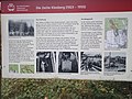 Glück-Auf-Anlage - Schild - Die Zeche Kleeberg (1923-1955).jpg 3,264 × 2,448; 6.94 MB
-
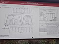 Glück-Auf-Anlage - Schild - Grubenausbau.jpg 3,264 × 2,448; 5.17 MB
-
 Grafik Nasser Wolkenbruch Trendelburg.jpg 2,145 × 3,248; 2.31 MB
-
 Informationstafel Das Lumbachtal.webp 4,032 × 3,024; 5.15 MB
-
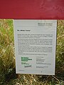 Informationstafel Die „Wilden Teiche“.jpg 3,240 × 4,320; 3.08 MB
-
 Informationstafel zum Naturschutzgebiet Urwald Sababurg 2014.jpg 4,320 × 3,240; 3 MB
-
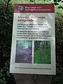 Informationstafel „Altwege, Hohlwege, Königstraße“.jpg 3,240 × 4,320; 4.38 MB
-
 Informationstafel „Baumliebe – eine Liebesgeschichte“.jpg 3,240 × 4,320; 3.01 MB
-
 Informationstafel „Die Marienkapelle am Wechselberg“.jpg 4,320 × 3,240; 2.72 MB
-
 Informationstafel „Die Sieburg – eine frühmittelalterliche Befestigung“.jpg 4,320 × 3,240; 2.67 MB
-
 Informationstafel „Franzosenwiesen“.jpg 4,320 × 3,240; 2.79 MB
-
 Informationstafel „Grabhügel der Bronzezeit“.jpg 4,320 × 3,240; 2.67 MB
-
 Informationstafel „Grenzstein des Amtes Trendelburg“.jpg 3,240 × 4,320; 2.74 MB
-
 Informationstafel „Historische Sababurger Wasserleitung von 1592“.jpg 2,448 × 3,264; 2.37 MB
-
 Informationstafel „Mittelalterliche Tongruben“.jpg 4,320 × 3,240; 2.8 MB
-
 Informationstafel „Tierwinter & Sternenzauber“.jpg 3,024 × 4,032; 1.03 MB
-
 Informationstafel „Wasser bergauf“ – Detail.jpg 2,448 × 3,264; 2.51 MB
-
 Informationstafel „Wasser bergauf“.jpg 4,032 × 3,024; 6.13 MB
-
 Judenbuche.jpg 4,608 × 2,592; 6.3 MB
-
 Karte Parkplatz Mühlenplatz.jpg 3,264 × 2,448; 1.84 MB
-
 Karte Reinhardswald Udenhäuser Stock.jpg 4,320 × 3,240; 5.52 MB
-
 Karte Wanderparkplatz Kühbacherwiese.jpg 4,320 × 3,240; 2.8 MB
-
 Karte Wanderwege im Urwald Sababurg.jpg 3,264 × 2,448; 1.99 MB
-
 Nasser Wolkenbruch Trendelburg Infotafel.jpg 2,560 × 1,920; 2.31 MB
-
 Panoramafoto Immenhausen-Holzhausen Eco Pfad.JPG 3,264 × 2,448; 3.6 MB
-
 Rastplatz Eselsbaum.jpg 3,024 × 4,032; 6.45 MB
-
 Reinhardswald - Der Wald im Wandel 2022-05-01.JPG 3,648 × 2,736; 4.15 MB
-
 Schild Naturschutzgebiet „Oberes Holzlappetal“.jpg 3,240 × 4,320; 2.65 MB
-
 Sitzbank beim Miniatur-Freilichtmuseum Mühlenplatz – Plakette.jpg 4,320 × 3,240; 4.79 MB
-
 Urwald Sababurg - Infotafel (1).jpg 2,816 × 4,224; 8.57 MB
-
 Urwald Sababurg - Infotafel (2).jpg 4,224 × 2,816; 8.45 MB
-
 Urwald Sababurg - Infotafel (3).jpg 4,139 × 2,689; 5.95 MB
-
 Urwald Sababurg - Infotafel (4).jpg 4,224 × 2,816; 6.92 MB
-
 Wandertafel Reinhardswald Urwald Sababurg.JPG 3,264 × 2,448; 2.79 MB
-
 Weg der Kohle aus dem Berg Eco Pfad Bergbau Holzhausen Reinhardswald.JPG 3,264 × 2,448; 4.46 MB


.JPG)

.JPG)
.jpg)


.jpg)
.jpg)
.jpg)
.jpg)

