Category:Information boards in Italy
Jump to navigation
Jump to search
Subcategories
This category has the following 13 subcategories, out of 13 total.
Media in category "Information boards in Italy"
The following 101 files are in this category, out of 101 total.
-
 " 09 - ITALY - Vineyard and signs Emilia Romagna wine - Mollino.jpg 4,288 × 2,848; 8.51 MB
-

-
 08 Plafó informatiu vora la SP477, al Valico di Castelluccio, detall amb mapa.jpg 2,048 × 1,536; 825 KB
-
 2016 Giardino di Carlo Alberto al Quirinale (Rome) 02.jpg 1,944 × 2,592; 2.57 MB
-
 2016 Rome Info Forum.jpg 2,592 × 1,944; 2.47 MB
-
 Attimis Inf 10.jpg 1,200 × 1,600; 300 KB
-
 Attimis Sup.jpg 1,200 × 1,600; 328 KB
-
 Bergtocht van Cogolo di Peio naar M.ga Levi in het Nationaal park Stelvio (Italië) 16.jpg 2,634 × 3,277; 8.98 MB
-
 Bergtocht van Cogolo di Peio naar M.ga Levi in het Nationaal park Stelvio (Italië) 17.jpg 2,826 × 3,376; 8.83 MB
-

-
 Bergtocht van parkeerplaats bij centrale Malga Mare naar Lago Lungo 27.jpg 4,490 × 2,625; 11.04 MB
-
 Bergtocht van parkeerplaats bij centrale Malga Mare naar Lago Lungo 28.jpg 3,354 × 2,753; 8.31 MB
-
 Bergtocht van parkeerplaats bij centrale Malga Mare naar Lago Lungo 31.jpg 3,498 × 3,172; 7.02 MB
-
 Bergtocht van parkeerplaats bij centrale Malga Mare naar Lago Lungo 32.jpg 4,296 × 3,439; 10.11 MB
-
 Bergtocht van parkeerplaats bij centrale Malga Mare naar Lago Lungo 41.jpg 3,354 × 2,753; 8.78 MB
-

-

-

-

-
 Bezoek aan kerk van San Rocco met daaromheen de militaire begraafplaats in Peio Paese 01.jpg 3,879 × 2,443; 8.28 MB
-
 Bezoek aan kerk van San Rocco met daaromheen de militaire begraafplaats in Peio Paese 02.jpg 1,661 × 2,141; 2.77 MB
-
 Bezoek aan kerk van San Rocco met daaromheen de militaire begraafplaats in Peio Paese 13.jpg 4,879 × 3,399; 10.43 MB
-
-
 Bezoek aan kerk van San Rocco met daaromheen de militaire begraafplaats in Peio Paese 20.jpg 3,666 × 2,902; 8.41 MB
-
-
 CAI finito.jpg 2,448 × 3,264; 4.42 MB
-
 Cartello del parco nei pressi della chiesa di Trignano.jpg 4,015 × 3,011; 2.12 MB
-
 Cartello Magnano.JPG 2,816 × 2,112; 1.69 MB
-
 Cartello turistico - Certosa - Ferrara.jpg 4,000 × 6,000; 6.44 MB
-
 Castello di Coia 3.tif 2,320 × 3,088; 41 MB
-
 Castello di Prampero.tif 2,320 × 3,088; 41 MB
-
 Castello di Zuccola 3.tif 2,320 × 3,088; 54.67 MB
-
 Cergneu 5.jpg 1,200 × 1,600; 300 KB
-
 Chiesa della Santissima Trinità e di San Filippo Neri 02.jpg 4,608 × 3,456; 2.05 MB
-
 Col del Colombo lungo il sistema difensivo Ortogonale 1.jpg 3,072 × 4,080; 4.63 MB
-
 Cucagna 3.jpg 1,600 × 1,200; 377 KB
-
 E30-02.jpg 4,080 × 3,072; 5.76 MB
-
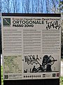
 Ecomuseo Grande Guerra Prealpi Vicentine - Ortogonale 1 - Passo Zovo.jpg 3,024 × 4,032; 3.35 MB
-

-
 Eucharistic Miracle of Lanciano - public documentation - the others.JPG 640 × 480; 126 KB
-
 Gilfenklamm Schild 1.jpg 3,232 × 3,232; 3.39 MB
-
 Gilfenklamm Schild 2.jpg 4,320 × 3,240; 5.09 MB
-

-
 Info Oratorio San Martino.jpg 1,033 × 2,275; 1.31 MB
-
 Info San Nicolo Umbria Sep23 A7C 07906.jpg 4,695 × 3,521; 10.18 MB
-

-

-
 Informatiebord. Bergtocht van parkeerplaats bij centrale Malga Mare naar Lago del Careser 01.jpg 3,940 × 3,303; 11.69 MB
-

-
 Informatiebord. Bergtocht van parkeerplaats bij centrale Malga Mare naar Lago del Careser 03.jpg 4,232 × 3,144; 11.61 MB
-

-

-
 Information board Resiutta, English.jpg 2,898 × 4,762; 9.09 MB
-
 Information board Resiutta, German.jpg 2,596 × 4,758; 8.47 MB
-
 Information board Resiutta, Italian.jpg 2,915 × 4,702; 8.74 MB
-
 Informationstafel Passerella Luciana Pacifici (Viareggio).jpg 1,642 × 1,244; 783 KB
-
 Inizio mulattiera per Col Fenêtre (Perloz).jpg 800 × 600; 99 KB
-
 Karte auf dem Soldatenfriedhof, Pomezia, Italia Dec 11, 2022 12-33-17 PM.jpeg 4,032 × 3,024; 4.01 MB
-
 Kip Jamesa Joycea u Trstu - informativni pano.jpg 3,777 × 5,035; 2.85 MB
-
 Lac du Miage 01.JPG 2,048 × 1,536; 717 KB
-
 Lageplan, Deutscher Soldatenfriedhof Pomezia, Italia Dec 11, 2022 12-30-40 PM.jpeg 3,024 × 4,032; 3.68 MB
-
 Mappa dei sentieri di Monteviale.jpg 3,072 × 3,450; 2.11 MB
-
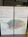
 Mappa Ecomuseo Grande Guerra Prealpi Vicentine presso Villa Zileri.jpg 3,024 × 4,032; 2.21 MB
-
 Mappa percorso Ortogonale 1 presso Villa Zileri.jpg 3,024 × 4,032; 1.97 MB
-
 Mira Buse train station.jpg 4,451 × 3,337; 1.78 MB
-
 Moncuni sulla Via dei Pellegrini Tratta Rivoli Castello - Avigliana Borgo San Pietro.jpg 1,456 × 2,592; 852 KB
-
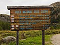
 Notice-board Path of the Righteous - The Righteous of the Mountain.jpg 1,800 × 4,000; 1.48 MB
-
 Pannello Informativo del sistema delle A.N.P.I.L. del Monte Pisano 2.jpg 3,612 × 3,000; 5.2 MB
-
 Pannello Informativo del sistema delle A.N.P.I.L. del Monte Pisano.jpg 4,000 × 3,000; 7.46 MB
-
 Pannello informativo Eccidio di Radio Cora.jpg 720 × 1,280; 95 KB
-
 Pannello tappa 9 Carcoforo.jpg 2,993 × 3,484; 6.71 MB
-
 Paolo Monti - Servizio fotografico (Torino, 1961) - BEIC 6337254.jpg 1,010 × 1,270; 1.29 MB
-
 Paolo Monti - Servizio fotografico (Torino, 1961) - BEIC 6337300.jpg 1,254 × 1,274; 1.72 MB
-
 Paolo Monti - Servizio fotografico (Torino, 1961) - BEIC 6337368.jpg 884 × 1,280; 1.13 MB
-
 Partecipanza Board 2.jpg 3,710 × 2,609; 3.63 MB
-
 Partecipanza Board.jpg 2,384 × 3,657; 3.48 MB
-
 Partistagno 1.jpg 1,600 × 1,200; 387 KB
-
 Partistagno.jpg 1,200 × 1,600; 464 KB
-
 Passo di Manfron Ortogonale 1.jpg 3,072 × 4,080; 3.6 MB
-
 Passo Zovo Ortogonale 1.jpg 3,024 × 4,032; 3.21 MB
-
 Patrocinio della Beata Vergine Maria e di San Filippo Neri (Chioggia) (3).jpg 3,456 × 4,608; 2.4 MB
-
 Pompei 17 34 28 549000.jpeg 3,024 × 4,032; 3.03 MB
-
 Santi Pietro e Paolo, detta San Pieretto (Chioggia) (2).jpg 4,608 × 3,456; 782 KB
-
 Sassi Superga rack tram 04.jpg 3,456 × 4,608; 2.47 MB
-
 Segnaletica Castelli di Artegna.png 962 × 1,282; 2.11 MB
-
 Segnaletica Castello della Motta.jpg 1,200 × 1,600; 279 KB
-
 Segnaletica per Castello di Guspergo.png 1,032 × 1,306; 2.59 MB
-
 Sentiero Fitness Lanucio.jpg 3,798 × 2,676; 5.66 MB
-
 Sentiero Geologico Mineralogico di Torrebelvicino.jpg 3,072 × 4,080; 3.84 MB
-
 Signpost with hiking map in Saint Vito of Lunella.jpg 1,800 × 4,000; 2.22 MB
-
 Tabliczka Brescia metro.jpg 4,608 × 3,456; 1,019 KB
-
 Tumolo C (Prato Rosello)-piantina.jpg 637 × 478; 180 KB
-
 Tumulo A (Prato Rosello)-piantina.jpg 637 × 478; 203 KB
-
 Tumulo X (Prato Rosello)-piantina.jpg 637 × 478; 198 KB
-
 Tumulo Z (Prato Rosello)-piantina.jpg 637 × 478; 195 KB
-
 V01 Pannello informativo della valle del Vajont anteriore.jpg 3,025 × 2,434; 1.31 MB
-
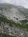 V17 Crinale della montagna sopra Casso.jpg 2,736 × 3,648; 2.22 MB
-
 Villa Zileri lungo l'Ortogonale 1.jpg 3,024 × 4,032; 2.01 MB
-

-
-


_02.jpg)


_16.jpg)
_17.jpg)
_naar_Colle_Tsa_S%C3%A8tse_in_Cogne_Valley_(Itali%C3%AB)._Informatiebord_boven_Gimillan_(1805m.).jpg)


._Informatiebord_01.jpg)
._Informatiebord_02.jpg)


.jpg)
.jpg)


_-_BEIC_6337254.jpg)
_-_BEIC_6337300.jpg)
_-_BEIC_6337368.jpg)


_(3).jpg)

_(2).jpg)


-piantina.jpg)
-piantina.jpg)
-piantina.jpg)
-piantina.jpg)


._in_het_Nationaal_park_Stelvio_(Itali%C3%AB)._Informatiepaneel.jpg)
_naar_Lago_del_Careser_(2603m)_33.jpg)
_naar_Lago_del_Careser_(2603m)_34.jpg)