Category:Images by John Mavin
Jump to navigation
Jump to search

Media in category "Images by John Mavin"
The following 56 files are in this category, out of 56 total.
-

-
 Admiralty Pier Dover Geograph 380546 71e924bc.jpg 640 × 427; 70 KB
-
 Beach Huts at Kingsdown, Kent - geograph.org.uk - 680162.jpg 640 × 423; 80 KB
-
 Castle in the Air - geograph.org.uk - 1038987.jpg 403 × 640; 37 KB
-

-
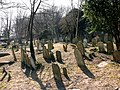 Cowgate Cemetery, Dover - geograph.org.uk - 377751.jpg 640 × 480; 196 KB
-
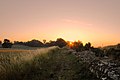
 Dawn at Dungeness - geograph.org.uk - 721983.jpg 640 × 424; 37 KB
-
-

-
 Dover Castle - geograph.org.uk - 843055.jpg 426 × 640; 91 KB
-
 Dover Marina - geograph.org.uk - 1070470.jpg 640 × 214; 39 KB
-
 Fishing Boats on Deal Beach, Kent - geograph.org.uk - 739735.jpg 640 × 423; 55 KB
-
 Fishing Boats on Deal Beach, Kent 2 - geograph.org.uk - 740800.jpg 426 × 640; 58 KB
-
 From Becket's Bridge, Romney Marsh - geograph.org.uk - 738312.jpg 640 × 426; 66 KB
-
 From Becket's Bridge, Romney Marsh 2 - geograph.org.uk - 739261.jpg 640 × 426; 64 KB
-
 Guston Mill, Kent - geograph.org.uk - 724723.jpg 640 × 426; 80 KB
-
 Lympne Castle, Kent - geograph.org.uk - 730491.jpg 640 × 426; 60 KB
-
 Lympne Castle, Kent - geograph.org.uk - 748348.jpg 426 × 640; 74 KB
-
 Old Fishing Boat at Dungeness - geograph.org.uk - 1069294.jpg 640 × 420; 80 KB
-
 Prince of Wales Pier, Dover - geograph.org.uk - 377770.jpg 640 × 426; 68 KB
-
 Ramsgate Breakwater - geograph.org.uk - 377221.jpg 640 × 422; 92 KB
-
 Richborough Fort from the South Wall - geograph.org.uk - 729482.jpg 426 × 640; 88 KB
-
 Ripple mill1.jpg 640 × 422; 43 KB
-
 Roman Fort at Richborough, Kent - geograph.org.uk - 380272.jpg 640 × 402; 130 KB
-
 Russell Gardens, Kearsney, Nr. Dover - geograph.org.uk - 728055.jpg 640 × 426; 73 KB
-
 Shakespeare Cliff, Dover - geograph.org.uk - 723575.jpg 640 × 414; 91 KB
-

-
 Silhouette of Dover Castle - geograph.org.uk - 735328.jpg 640 × 436; 42 KB
-

-

-
 The Chalk Pit, Priory Hill, Dover - geograph.org.uk - 620679.jpg 640 × 426; 66 KB
-

-
 The former Marine Station, Dover - geograph.org.uk - 735239.jpg 640 × 426; 104 KB
-

-
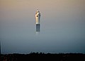 The New Lighthouse at Dungeness - geograph.org.uk - 409660.jpg 640 × 466; 51 KB
-
 The River Lynher at low tide - geograph.org.uk - 1049579.jpg 640 × 426; 114 KB
-

-
-

-

-

-

-

-
 Victoria Park, Dover - geograph.org.uk - 732739.jpg 640 × 427; 103 KB
-
 Waterloo Crescent, Dover-geograph-2140513.jpg 422 × 640; 86 KB
-
 Waterloo Crescent, Dover-geograph-2213023.jpg 2,566 × 4,101; 2.08 MB
-
 Wellington Dock, Dover - geograph.org.uk - 682299.jpg 640 × 413; 76 KB
-
 Whinless Down, Dover - geograph.org.uk - 732771.jpg 640 × 426; 49 KB
-
 Another Dawn at Dungeness. - geograph.org.uk - 1069300.jpg 640 × 402; 63 KB
-
 Colliford Lake on Bodmin Moor - geograph.org.uk - 773114.jpg 640 × 426; 90 KB
-
 Cottages near Kingsdown beach, Kent. - geograph.org.uk - 714888.jpg 423 × 640; 67 KB
-
 Denge Marsh, Kent - geograph.org.uk - 721993.jpg 640 × 428; 61 KB
-
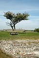
 Dying Tree above Romney Marsh - geograph.org.uk - 731897.jpg 640 × 477; 139 KB
-
 Fishing Boats and Sheds at Dungeness - geograph.org.uk - 721990.jpg 640 × 426; 30 KB
-

-
 West Down - geograph.org.uk - 385748.jpg 640 × 472; 98 KB


