Category:Images by David Clark
Jump to navigation
Jump to search

Media in category "Images by David Clark"
The following 200 files are in this category, out of 276 total.
(previous page) (next page)-
 "Fire" - geograph.org.uk - 1518822.jpg 391 × 640; 46 KB
-
 A Brick in The Kiln (Tosson Lime Kiln) - geograph.org.uk - 1530623.jpg 640 × 426; 115 KB
-
 A Bullrush pond - geograph.org.uk - 1580060.jpg 640 × 426; 111 KB
-
 A gate onto the Moor - geograph.org.uk - 1525992.jpg 640 × 480; 97 KB
-
 A Gate onto the moor - geograph.org.uk - 1610956.jpg 640 × 426; 78 KB
-
 A Mouse on a wall - geograph.org.uk - 1520635.jpg 640 × 425; 76 KB
-
 A proud tree - geograph.org.uk - 1753347.jpg 3,000 × 4,000; 2.73 MB
-
 A seat - geograph.org.uk - 1671973.jpg 4,000 × 3,000; 5.15 MB
-
 A seat - geograph.org.uk - 1714821.jpg 4,000 × 3,000; 4.81 MB
-
 A stand of Beech trees - geograph.org.uk - 1742718.jpg 4,000 × 3,000; 4.52 MB
-

-
 A697-B6345 Junction - geograph.org.uk - 1653860.jpg 640 × 413; 89 KB
-
 Abandoned on the Quayside - geograph.org.uk - 1704820.jpg 4,000 × 3,000; 2.33 MB
-
 Access point - geograph.org.uk - 1522376.jpg 640 × 480; 109 KB
-
 Across the Moor - geograph.org.uk - 1610890.jpg 640 × 426; 46 KB
-
 Agricultural building - geograph.org.uk - 1734646.jpg 3,984 × 2,517; 3.96 MB
-
 Aldi - Gateshead Metro Centre geograph-4181870-by-David-Clark.jpg 1,444 × 1,083; 273 KB
-
 Alley at top of steps - geograph.org.uk - 1533735.jpg 640 × 480; 101 KB
-
 Allotments under snow at Longframlington - geograph.org.uk - 1629650.jpg 640 × 426; 107 KB
-
 Alnwick branch of Morrisons - geograph.org.uk - 1605664.jpg 640 × 426; 68 KB
-
 Alnwick branch of Sainsbury's - geograph.org.uk - 1734682.jpg 4,000 × 3,000; 4.1 MB
-
 Alnwick Bus Station - geograph.org.uk - 1605657.jpg 640 × 299; 40 KB
-
 Alnwick cemetery loopholed wall - geograph.org.uk - 1734741.jpg 4,000 × 3,000; 5.4 MB
-
 An Autumn view of the disused Lily Pond - geograph.org.uk - 1546276.jpg 640 × 424; 122 KB
-
 An Idle Tractor - geograph.org.uk - 1701532.jpg 4,000 × 3,000; 4.76 MB
-
 An interesting weather vane - geograph.org.uk - 1517703.jpg 480 × 640; 81 KB
-
 An Old Bridge - geograph.org.uk - 1742749.jpg 4,000 × 3,000; 5.88 MB
-
 Anything Goes - geograph.org.uk - 1606120.jpg 640 × 391; 60 KB
-
 Approaching Longframlington - geograph.org.uk - 1571614.jpg 640 × 434; 85 KB
-
 Ashington Town hall - geograph.org.uk - 1508355.jpg 525 × 640; 77 KB
-
 At work in the fields - geograph.org.uk - 1690567.jpg 4,000 × 2,664; 1.43 MB
-
 Back lane to Linden Hall - geograph.org.uk - 1567468.jpg 640 × 426; 92 KB
-

-

-
 Baling the Straw - geograph.org.uk - 1469143.jpg 640 × 480; 62 KB
-
 Barn at Ewart Park - geograph.org.uk - 1569006.jpg 640 × 426; 86 KB
-
 Beech trees - geograph.org.uk - 1713163.jpg 4,000 × 3,000; 5.4 MB
-
 Beehives at Thirston - geograph.org.uk - 1703093.jpg 4,000 × 3,000; 5.84 MB
-
 Blagdon Estate road - geograph.org.uk - 1549732.jpg 640 × 353; 62 KB
-
 Blagdon Estate, South Lodge. - geograph.org.uk - 1437690.jpg 640 × 480; 98 KB
-
 Blue Boat at Amble - geograph.org.uk - 1537164.jpg 640 × 508; 50 KB
-
 Boat on Coquet - geograph.org.uk - 1536977.jpg 572 × 640; 64 KB
-
 Boundary Stone 'R' - geograph.org.uk - 1610949.jpg 640 × 515; 126 KB
-
 Boundary Stone - geograph.org.uk - 1610901.jpg 640 × 426; 93 KB
-
 Boundary Stone at Debdon - geograph.org.uk - 1610917.jpg 640 × 538; 126 KB
-

-
 Bridge over Lorbottle Burn - geograph.org.uk - 1558923.jpg 640 × 426; 80 KB
-
 Bridge over River Ken - geograph.org.uk - 1422645.jpg 640 × 480; 115 KB
-
 Bridge over stream - geograph.org.uk - 1743323.jpg 4,000 × 3,000; 4.51 MB
-

-
 Bridge over unnamed burn - geograph.org.uk - 1753334.jpg 4,000 × 3,000; 4.03 MB
-
 Brinkburn Station Cottage (geograph 1938531).jpg 4,000 × 3,000; 4.2 MB
-
 Bull Barrier - geograph.org.uk - 1584963.jpg 640 × 425; 134 KB
-
 Burgh Hill. - geograph.org.uk - 1529824.jpg 640 × 426; 78 KB
-
 Bus near Backworth Metro Station - geograph.org.uk - 3056716.jpg 4,000 × 3,000; 3.3 MB
-

-
 Bywell Farm Cottages - geograph.org.uk - 1567437.jpg 640 × 426; 106 KB
-
 Bywell Shooting ground. - geograph.org.uk - 1567430.jpg 640 × 426; 56 KB
-
 Ceasar, Kirkcudbright's town cat. - geograph.org.uk - 1422608.jpg 640 × 480; 123 KB
-
 Church Street - geograph.org.uk - 1440603.jpg 640 × 168; 26 KB
-

-
 Coat of Arms - geograph.org.uk - 1568802.jpg 640 × 426; 69 KB
-
 Collecting Straw - geograph.org.uk - 1603839.jpg 640 × 480; 76 KB
-
 Country Lane - geograph.org.uk - 1709789.jpg 3,966 × 2,342; 2.7 MB
-
 Crossford Bridge - geograph.org.uk - 1581602.jpg 640 × 427; 131 KB
-
 Dennis's garage - geograph.org.uk - 1572777.jpg 640 × 426; 56 KB
-
 Dirty Milepost - geograph.org.uk - 1713104.jpg 3,000 × 4,000; 6.49 MB
-
 Disused lodge Building - geograph.org.uk - 1568626.jpg 640 × 426; 84 KB
-
 Drive way to Hall Hill farm - geograph.org.uk - 1629628.jpg 470 × 640; 106 KB
-

-
 Duck Weather vane - geograph.org.uk - 1517707.jpg 640 × 480; 51 KB
-
 Ducks on a sandbank - geograph.org.uk - 1704246.jpg 2,831 × 3,000; 2.11 MB
-
 Ewart Newtown - geograph.org.uk - 1568999.jpg 640 × 426; 51 KB
-
 Eyecatcher at Alnwick - geograph.org.uk - 1746144.jpg 3,000 × 4,000; 5.71 MB
-
 Eyecatcher Obelisk - geograph.org.uk - 1746152.jpg 4,000 × 3,000; 5.17 MB
-
 Farm chimney - geograph.org.uk - 1690561.jpg 3,988 × 2,267; 2.93 MB
-
 Farm gateway - geograph.org.uk - 1549701.jpg 640 × 417; 66 KB
-
 Farm steading at Longframlington - geograph.org.uk - 1713151.jpg 3,994 × 2,318; 2.37 MB
-
 Fences and gates - geograph.org.uk - 1753359.jpg 4,000 × 3,000; 3.73 MB
-
 Field Barn at Bywell. - geograph.org.uk - 1567455.jpg 640 × 426; 77 KB
-
 Field of Hope - geograph.org.uk - 1804015.jpg 4,000 × 3,000; 3.83 MB
-
 Field track to How Dean - geograph.org.uk - 1568817.jpg 640 × 426; 77 KB
-
 Finger post - geograph.org.uk - 1765867.jpg 3,000 × 4,000; 3.04 MB
-
 Finger Post at Junction, Gilsland, Cumbria.jpg 3,000 × 4,000; 4.44 MB
-
 Fireplace in a strange place. - geograph.org.uk - 1552775.jpg 640 × 426; 43 KB
-
 Fishing Boats - geograph.org.uk - 1591074.jpg 640 × 480; 87 KB
-
 Five Gates - geograph.org.uk - 1587611.jpg 640 × 426; 111 KB
-
 Footbridge and ford. - geograph.org.uk - 1508692.jpg 640 × 480; 134 KB
-
 Footbridge over The Tod Burn (geograph 1860269).jpg 1,600 × 1,200; 737 KB
-
 Footpath sign - geograph.org.uk - 1560096.jpg 640 × 426; 89 KB
-
 Footpath sign and farm sign - geograph.org.uk - 1734662.jpg 3,000 × 4,000; 4.66 MB
-
 Footpath sign to Whorrel bank - geograph.org.uk - 1690551.jpg 4,000 × 2,664; 4.45 MB
-
 Ford at Forest Burn - geograph.org.uk - 1566029.jpg 640 × 480; 137 KB
-

-

-
 Furnishings and General Ironmongers - geograph.org.uk - 1758177.jpg 4,000 × 3,000; 3.35 MB
-
 Gate way onto A697 road - geograph.org.uk - 1629681.jpg 640 × 426; 117 KB
-
 Gateway onto Garleigh Moor - geograph.org.uk - 1567524.jpg 640 × 426; 95 KB
-
 Great Tosson Farm - geograph.org.uk - 1530527.jpg 640 × 457; 90 KB
-
 Great Tosson Lime Kiln - geograph.org.uk - 1537615.jpg 640 × 426; 113 KB
-
 Hedley wood Bank Pill Box - geograph.org.uk - 1715820.jpg 4,000 × 3,000; 4.99 MB
-
 High House Brewery visitor centre - geograph.org.uk - 1690827.jpg 4,000 × 2,664; 3.69 MB
-
 Highland Pipe Band - geograph.org.uk - 1530564.jpg 640 × 426; 70 KB
-
 Holy Trinity Matfen - geograph.org.uk - 1690808.jpg 4,000 × 2,664; 3.03 MB
-

-
 Housing development - geograph.org.uk - 1758202.jpg 4,000 × 3,000; 2.68 MB
-
 Ice Cream stand, Town, Beamish Museum, 19 July 2010.jpg 4,000 × 3,000; 2.37 MB
-
 Ice on Bolam Lake - geograph.org.uk - 1712365.jpg 4,000 × 2,664; 3.5 MB
-
 Iced over Puddle - geograph.org.uk - 1724926.jpg 4,000 × 3,000; 5.63 MB
-
 It's this way- - geograph.org.uk - 1581556.jpg 640 × 426; 59 KB
-
 Jubilee Fountain - geograph.org.uk - 1569022.jpg 426 × 640; 103 KB
-
 Kingston Park - 1 - geograph-1813157.jpg 3,994 × 2,493; 2.39 MB
-
 Kingston Park - 2 - geograph-1813866.jpg 3,000 × 4,000; 3.39 MB
-
 Kingston Park - 3 - geograph-1813910.jpg 3,600 × 2,400; 2.79 MB
-
 Ladder stile - geograph.org.uk - 1763518.jpg 4,000 × 3,000; 4.67 MB
-
 Lady's Well, among the trees. - geograph.org.uk - 1517674.jpg 640 × 480; 78 KB
-

-

-

-
 Looking out of West Thirston Pillbox - geograph.org.uk - 1733286.jpg 4,000 × 3,000; 1.79 MB
-
 Looking towards Simonside Hills - geograph.org.uk - 1464236.jpg 640 × 480; 92 KB
-
 Looking West - geograph.org.uk - 1701524.jpg 3,571 × 2,632; 3.93 MB
-

-
 Low Town farm - geograph.org.uk - 1587608.jpg 640 × 426; 99 KB
-
 Low Town farm - geograph.org.uk - 1756838.jpg 4,000 × 3,000; 3.38 MB
-
 Malcolm's Cross - geograph.org.uk - 1533754.jpg 480 × 640; 84 KB
-
 Midday in Morpeth - geograph.org.uk - 1758190.jpg 1,673 × 2,113; 1.02 MB
-
 Mile post - geograph.org.uk - 1756870.jpg 4,000 × 3,000; 6.95 MB
-
 Military buildings - geograph.org.uk - 1704219.jpg 4,000 × 3,000; 3.9 MB
-
 Milkhope - geograph.org.uk - 1581633.jpg 640 × 426; 107 KB
-
 Millennium seat Ulgham - geograph.org.uk - 1544362.jpg 640 × 426; 95 KB
-
 Miners Cottages, Pit Village, Beamish Museum, 19 July 2010.jpg 4,000 × 3,000; 3.63 MB
-

-
 Mobile Library - geograph.org.uk - 1703098.jpg 3,946 × 2,493; 2.63 MB
-
 Morpeth Town Hall - geograph.org.uk - 1552766.jpg 523 × 640; 87 KB
-
 Mr Green The Butchers - geograph.org.uk - 1524126.jpg 640 × 403; 60 KB
-
 Mystery excavation at Netherton Pond. - geograph.org.uk - 1558907.jpg 640 × 426; 120 KB
-
 New Beech trees - geograph.org.uk - 1725324.jpg 4,000 × 3,000; 3.87 MB
-
 New(ish) road junction on the A1 - geograph.org.uk - 1549689.jpg 640 × 414; 53 KB
-

-
 Obelisk at Lemington Hall - geograph.org.uk - 1522366.jpg 640 × 442; 47 KB
-
 Old bridge over a stream - geograph.org.uk - 1767711.jpg 4,000 × 3,000; 6.34 MB
-
 Old Byre - geograph.org.uk - 1420305.jpg 640 × 480; 134 KB
-
 Open Countryside - geograph.org.uk - 1517176.jpg 640 × 480; 105 KB
-
 Over the Shotton burn - geograph.org.uk - 2148096.jpg 4,000 × 3,000; 5.47 MB
-
 Overgrass Tower - geograph.org.uk - 1421243.jpg 640 × 480; 86 KB
-
 P309 This Pillbox number - geograph.org.uk - 1721919.jpg 3,000 × 4,000; 3.61 MB
-
 Part of Edlingham castle walls - geograph.org.uk - 1562946.jpg 640 × 426; 49 KB
-

-

-
 Percy's Leap - geograph.org.uk - 1440500.jpg 640 × 480; 143 KB
-
 Percys Cross, Beanley (geograph 3554843).jpg 1,920 × 2,560; 2.16 MB
-
 Pill Box - geograph.org.uk - 1715825.jpg 3,990 × 2,523; 3.84 MB
-
 Pill Box at Weldon Bridge - geograph.org.uk - 1717873.jpg 3,000 × 4,000; 5.86 MB
-
 Pillbox at Pauperhaugh - geograph.org.uk - 1721228.jpg 4,000 × 3,000; 5.37 MB
-
 Pillbox at West Thirston - geograph.org.uk - 1733276.jpg 4,000 × 3,000; 4.42 MB
-
 Portico to The Sanderson Arcade - geograph.org.uk - 1593794.jpg 397 × 640; 59 KB
-
 Portpatrick harbour - geograph.org.uk - 1670248.jpg 4,000 × 3,000; 2.54 MB
-
 Posing for the camera at Glen Aln - geograph.org.uk - 1523683.jpg 640 × 480; 101 KB
-
 Postbox at Beacon Hill - geograph.org.uk - 1576183.jpg 478 × 640; 122 KB
-
 Public Footpath - geograph.org.uk - 1702299.jpg 4,000 × 3,000; 6.44 MB
-
 Public Footpath - geograph.org.uk - 1702353.jpg 4,000 × 3,000; 5.95 MB
-
 Public Footpath on farm track - geograph.org.uk - 1733225.jpg 4,000 × 3,000; 5.19 MB
-
 Public Footpath sign in the snow - geograph.org.uk - 1650104.jpg 426 × 640; 82 KB
-

-
 Reclaimed Opencast workings. - geograph.org.uk - 1581884.jpg 640 × 426; 77 KB
-
 Red Acre Mill on The Rochdale Canal (geograph 2670057).jpg 4,000 × 3,000; 4.14 MB
-
 Remote Post Box - geograph.org.uk - 1525854.jpg 426 × 640; 117 KB
-
 Rigg and furrow north of the village - geograph.org.uk - 1707679.jpg 4,000 × 3,000; 3.45 MB
-
 Right of way exit to A697 - geograph.org.uk - 1560085.jpg 640 × 426; 107 KB
-
 Rimside Gardens - geograph.org.uk - 1700147.jpg 4,000 × 3,000; 4.04 MB
-
 Road Bridge - geograph.org.uk - 1559779.jpg 640 × 426; 110 KB
-
 Road to Lowtown - geograph.org.uk - 1587161.jpg 640 × 426; 67 KB
-
 Road to Sheil Dykes farm - geograph.org.uk - 1709775.jpg 4,000 × 3,000; 4.7 MB
-
 Rookwood House. - geograph.org.uk - 1572781.jpg 640 × 426; 63 KB
-
 Royal Mail PostBox - geograph.org.uk - 1603847.jpg 640 × 480; 76 KB
-
 Rural Crossroads - geograph.org.uk - 1756813.jpg 4,000 × 2,360; 3.11 MB
-
 Seat with a view at Beacon Hill - geograph.org.uk - 1576175.jpg 640 × 426; 122 KB
-
 Services at Milkhope Centre - geograph.org.uk - 1581885.jpg 640 × 426; 129 KB
-
 Sign Post to Pigdon - geograph.org.uk - 1767673.jpg 3,000 × 4,000; 3.06 MB
-
 Simonside Hills through a gate - geograph.org.uk - 1483753.jpg 640 × 480; 84 KB
-
 Sluice gate at Netherton pond - geograph.org.uk - 1563629.jpg 640 × 426; 105 KB
-
 Snow on Weldon Bridge - geograph.org.uk - 1626817.jpg 640 × 426; 75 KB
-
 South of Callaly Crag - geograph.org.uk - 1429788.jpg 640 × 480; 78 KB
-
 Speed Camera - geograph.org.uk - 1702388.jpg 4,000 × 3,000; 4.82 MB
-

-
 Sports Pavilion at Swarland - geograph.org.uk - 1445284.jpg 640 × 480; 113 KB
-
 St Cuthberts Church Hebron - geograph.org.uk - 1424600.jpg 640 × 480; 113 KB
-
 St John's Church Edlingham - geograph.org.uk - 1562941.jpg 426 × 640; 116 KB
-
 St Mary's Church Rooms - geograph.org.uk - 1713173.jpg 4,000 × 3,000; 3.74 MB
-
-
 Stannington Service Station - geograph.org.uk - 1580087.jpg 640 × 358; 50 KB
-
 Start of Bridleway - geograph.org.uk - 1725314.jpg 4,000 × 3,000; 4.47 MB
-
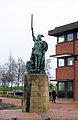 Statue of a Viking Warrior at County Hall (geograph 1683957).jpg 2,238 × 3,453; 1.79 MB
-
 Steps - geograph.org.uk - 1524542.jpg 480 × 640; 151 KB
-
 Steps - geograph.org.uk - 1533745.jpg 640 × 480; 145 KB
-

-
 Stile on Public Footpath - geograph.org.uk - 1702374.jpg 4,000 × 3,000; 4.46 MB
-
 Stile on Public Footpath - geograph.org.uk - 1763528.jpg 3,000 × 4,000; 4.96 MB
-
 Stobswood Opencast coal mine - geograph.org.uk - 1422559.jpg 640 × 480; 99 KB

_-_geograph.org.uk_-_1530623.jpg)


.jpg)


.jpg)


_road_junction_on_the_A1_-_geograph.org.uk_-_1549689.jpg)


.jpg)


.jpg)


.jpg)


