Category:Images by Adrian Platt
Jump to navigation
Jump to search

Media in category "Images by Adrian Platt"
The following 200 files are in this category, out of 496 total.
(previous page) (next page)-
 A snowy Dartmoor panorama - geograph.org.uk - 1149226.jpg 640 × 427; 71 KB
-
 A snowy station yard, South Brent (geograph 2228773).jpg 1,024 × 683; 204 KB
-
 A1 Tornado, Newton Abbot - geograph.org.uk - 1715873.jpg 1,024 × 683; 174 KB
-
 Abercastle at low tide - geograph.org.uk - 932546.jpg 640 × 425; 86 KB
-

-
 Addicombe Brook, Lukesland Gardens - geograph.org.uk - 1604355.jpg 640 × 427; 84 KB
-

-
 An Ghraig and Cruach Mharthain - geograph.org.uk - 1577009.jpg 427 × 640; 74 KB
-
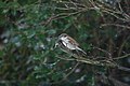
 An observant Pied Wagtail - geograph.org.uk - 1160338.jpg 640 × 427; 28 KB
-
 Anchor House in The Strand - geograph.org.uk - 1182228.jpg 640 × 427; 56 KB
-
 Ardfert Cathedral - geograph.org.uk - 1426381.jpg 640 × 427; 57 KB
-
 Avocet at Tresillian in Topsham - geograph.org.uk - 1182168.jpg 640 × 427; 66 KB
-
 Avocet on the Exe - geograph.org.uk - 1182249.jpg 640 × 427; 54 KB
-
 Avocet on the Exe at Topsham - geograph.org.uk - 1182153.jpg 640 × 427; 72 KB
-
 Avocet over Greenland - geograph.org.uk - 1182239.jpg 640 × 427; 63 KB
-
 Avon Valley at Shipley Bridge - geograph.org.uk - 1139122.jpg 640 × 427; 99 KB
-
 Avonwick Post Office and Village Stores - geograph.org.uk - 1066230.jpg 640 × 427; 100 KB
-
 Ballytrasna farmstead - geograph.org.uk - 1370309.jpg 640 × 427; 77 KB
-
 Barge colours, Grand Western Canal - geograph.org.uk - 1117290.jpg 427 × 640; 99 KB
-
 Barrow Harbour - geograph.org.uk - 1476362.jpg 640 × 427; 93 KB
-
 Basin Street in Lanreath - geograph.org.uk - 1139386.jpg 640 × 427; 75 KB
-
 Batten Bay - geograph.org.uk - 1169560.jpg 640 × 427; 78 KB
-
 Beech tree near Harbourneford Cross - geograph.org.uk - 1159984.jpg 640 × 427; 99 KB
-
 Black Tor - geograph.org.uk - 1765042.jpg 1,024 × 768; 206 KB
-
 Blasket Sound - geograph.org.uk - 1373465.jpg 640 × 427; 33 KB
-
 Blennerville Station - geograph.org.uk - 1398746.jpg 640 × 427; 56 KB
-
 Blue tit - geograph.org.uk - 1160331.jpg 640 × 427; 53 KB
-
 Blue Tit on a peanut feeder - geograph.org.uk - 1160342.jpg 640 × 427; 44 KB
-
 Bocaddon Farm - geograph.org.uk - 1139374.jpg 640 × 427; 82 KB
-
 Bodmin Lodge on the Boconnoc Estate - geograph.org.uk - 1139959.jpg 640 × 427; 98 KB
-
 Braddock Church - geograph.org.uk - 1139949.jpg 427 × 640; 125 KB
-
 Braddock Church - geograph.org.uk - 1139952.jpg 640 × 427; 87 KB
-
 Braddock Churchyard - geograph.org.uk - 1139954.jpg 427 × 640; 93 KB
-
 Brandon Bay - geograph.org.uk - 1576914.jpg 640 × 427; 46 KB
-
 Brandon Bay - geograph.org.uk - 1576938.jpg 640 × 427; 82 KB
-
 Brandon Harbour - geograph.org.uk - 1506051.jpg 640 × 427; 58 KB
-
 Brandon Mountain, Co Kerry - geograph.org.uk - 1372054.jpg 640 × 427; 54 KB
-
 Brent Geese on the River Exe Estuary - geograph.org.uk - 1181339.jpg 640 × 427; 92 KB
-
 Brent Hill and Beara Common - geograph.org.uk - 1149332.jpg 640 × 427; 58 KB
-
 Brent Hill, from South Brent - geograph.org.uk - 830627.jpg 640 × 480; 62 KB
-
 Brent Mill Industrial Estate - geograph.org.uk - 1112469.jpg 640 × 427; 64 KB
-
 Brent Mill Industrial Estate - geograph.org.uk - 1112482.jpg 640 × 427; 63 KB
-
 Bridge and Toll House at Brent Mill - geograph.org.uk - 1112425.jpg 640 × 427; 81 KB
-
 Bridge parapet, Upper Dean - geograph.org.uk - 1128587.jpg 427 × 640; 82 KB
-
 Bridge parapet, Upper Dean - geograph.org.uk - 1128592.jpg 640 × 427; 109 KB
-
 Bridge plaque, near Ballytrasna - geograph.org.uk - 1397104.jpg 427 × 640; 106 KB
-
 Bridge, Upper Dean - geograph.org.uk - 1128580.jpg 427 × 640; 128 KB
-
 Bristol Channel from Penarth cliffs - geograph.org.uk - 1167276.jpg 640 × 480; 48 KB
-
 Buckfastleigh Race Course - geograph.org.uk - 1097802.jpg 640 × 427; 51 KB
-
 Holy Trinity Church, Buckfastleigh - geograph.org.uk - 1222250.jpg 427 × 640; 69 KB
-
-

-
 Canal Tea Garden, Tiverton - geograph.org.uk - 1112496.jpg 427 × 640; 73 KB
-
 Canal Tea Rooms and Garden, Tiverton - geograph.org.uk - 1112503.jpg 640 × 427; 48 KB
-

-
-
 Castlegregory and the Slieve Mish - geograph.org.uk - 1397185.jpg 640 × 427; 44 KB
-
 Cattedown from Mount Batten - geograph.org.uk - 1169232.jpg 640 × 427; 72 KB
-
 Cattedown Wharves - geograph.org.uk - 1214597.jpg 640 × 427; 64 KB
-

-
 Chestnut tree at Saltram House - geograph.org.uk - 1096686.jpg 480 × 640; 144 KB
-
 Chough, near Slea Head - geograph.org.uk - 1373508.jpg 640 × 427; 63 KB
-
 Church Lane, Stinsford - geograph.org.uk - 1394987.jpg 640 × 427; 111 KB
-
 Church Lane, Stinsford - geograph.org.uk - 1395046.jpg 427 × 640; 97 KB
-
 Clapper Cottage, Upper Dean - geograph.org.uk - 1127726.jpg 640 × 427; 74 KB
-
 Cliffs on Slea Head - geograph.org.uk - 1506226.jpg 640 × 427; 75 KB
-
 Cliffs on Slea Head - geograph.org.uk - 1506237.jpg 640 × 427; 75 KB
-
 Clogher Strand - geograph.org.uk - 1373557.jpg 640 × 427; 74 KB
-
 Coast near Ballyickeen - geograph.org.uk - 1373536.jpg 640 × 427; 58 KB
-
 Coastal dunes near Castlegregory - geograph.org.uk - 1370200.jpg 640 × 427; 70 KB
-
 Coastline at Gowlane - geograph.org.uk - 1426572.jpg 640 × 427; 69 KB
-
 Cobble Stone Cottage, Upper Dean - geograph.org.uk - 1127636.jpg 640 × 427; 49 KB
-
 Cobbly Lane, Avonwick - geograph.org.uk - 1066315.jpg 640 × 427; 135 KB
-
 Cobbly Lane, Avonwick - geograph.org.uk - 1066324.jpg 427 × 640; 105 KB
-
 Cobbly Lane, Avonwick - geograph.org.uk - 1066338.jpg 640 × 427; 133 KB
-
 Cobbly Lane, Avonwick - geograph.org.uk - 1066367.jpg 640 × 427; 137 KB
-
 Cockwood and the Haldon Hills - geograph.org.uk - 1181296.jpg 640 × 427; 52 KB
-
 Cockwood Harbour - geograph.org.uk - 1179634.jpg 640 × 427; 68 KB
-
 Collared Dove - geograph.org.uk - 1160339.jpg 640 × 427; 44 KB
-
 Combine harvester near Braddock Church - geograph.org.uk - 1139946.jpg 640 × 427; 106 KB
-
 Connor Pass - geograph.org.uk - 1575702.jpg 427 × 640; 79 KB
-

-
 Coral Gables Guesthouse, Tagoat - geograph.org.uk - 1370013.jpg 640 × 427; 73 KB
-
 Cotehele House - geograph.org.uk - 1604485.jpg 427 × 640; 99 KB
-
 Cotehele House, inner courtyard - geograph.org.uk - 1604442.jpg 640 × 427; 69 KB
-
 Cotehele House, inner courtyard - geograph.org.uk - 1604446.jpg 427 × 640; 107 KB
-
 Cotehele House, South Front - geograph.org.uk - 1604431.jpg 640 × 427; 70 KB
-
 Cotehele House, south front - geograph.org.uk - 1604434.jpg 640 × 427; 74 KB
-

-

-
-
 Cotehele House, The Christmas Garland - geograph.org.uk - 1604477.jpg 640 × 427; 109 KB
-
-
 Cotehele House, the East front - geograph.org.uk - 1604492.jpg 640 × 427; 103 KB
-
 Cotehele House, the Terraced Garden - geograph.org.uk - 1604509.jpg 640 × 427; 104 KB
-
 Cotehele House, the Valley Garden - geograph.org.uk - 1604536.jpg 640 × 427; 111 KB
-

-
 Cottages at Chapeltown - geograph.org.uk - 1399368.jpg 640 × 427; 71 KB
-
 Cottages in Lanreath - geograph.org.uk - 1139940.jpg 640 × 427; 95 KB
-
 Cottages in Totnes Road, South Brent - geograph.org.uk - 1010281.jpg 640 × 427; 62 KB
-
 Cottages in Trefin - geograph.org.uk - 932468.jpg 640 × 423; 68 KB
-
 Cottages, Upper Dean - geograph.org.uk - 1127713.jpg 640 × 427; 50 KB
-
 Coumeenoole Beach - geograph.org.uk - 1576988.jpg 640 × 427; 70 KB
-
 Coumeenoule Bay - geograph.org.uk - 1507139.jpg 640 × 427; 57 KB
-
 Country lane near Blennerville - geograph.org.uk - 1370231.jpg 640 × 427; 61 KB
-
-

-
 Cousens Garage, Avonwick - geograph.org.uk - 1067473.jpg 640 × 427; 51 KB
-
 Crooksball in Duloe Parish - geograph.org.uk - 894105.jpg 640 × 427; 84 KB
-
 Dean Burn - geograph.org.uk - 1128606.jpg 427 × 640; 105 KB
-
 Dean Court Farm Shop - geograph.org.uk - 1113478.jpg 640 × 427; 47 KB
-
 Dean Prior - geograph.org.uk - 1097728.jpg 640 × 427; 93 KB
-
 Dean Prior - geograph.org.uk - 1097762.jpg 640 × 427; 68 KB
-
 Dean Prior - geograph.org.uk - 1715795.jpg 1,024 × 683; 164 KB
-
 Dean Prior Church - geograph.org.uk - 1097670.jpg 640 × 427; 76 KB
-
 Dean Prior Church - geograph.org.uk - 1097695.jpg 640 × 427; 54 KB
-
 Dean Prior Church - geograph.org.uk - 1127511.jpg 640 × 427; 88 KB
-
 Dean Prior Parish Hall - geograph.org.uk - 1127671.jpg 640 × 427; 56 KB
-
 Delamore House, Cornwood - geograph.org.uk - 1369947.jpg 640 × 427; 83 KB
-
 Derelict Rover Motor car, Upper Dean - geograph.org.uk - 1127695.jpg 640 × 427; 99 KB
-

-

-

-
 Dundag Bay Boathouse - geograph.org.uk - 1478895.jpg 640 × 427; 76 KB
-
 Dundag Bay on Muckross Lake - geograph.org.uk - 1575828.jpg 640 × 427; 100 KB
-
 Dundag Bay, Muckross Lake - geograph.org.uk - 1575848.jpg 640 × 427; 80 KB
-
 Dunmore Head from Coumeenoole - geograph.org.uk - 1577001.jpg 640 × 427; 56 KB
-

-
 East Manley, Grand Western Canal - geograph.org.uk - 1117208.jpg 640 × 427; 92 KB
-

-
-
 Exton village with a flock of Dunlin - geograph.org.uk - 1181354.jpg 640 × 427; 78 KB
-
 Fairwater Conservative Club, Cardiff - geograph.org.uk - 1136886.jpg 640 × 427; 54 KB
-
 Fairwater Conservative Club, Cardiff - geograph.org.uk - 1136894.jpg 640 × 427; 111 KB
-
 Fairwater Conservative Club, Cardiff - geograph.org.uk - 1136914.jpg 640 × 427; 66 KB
-
 Farmland in Fermoyle - geograph.org.uk - 1475857.jpg 640 × 427; 77 KB
-
 Fenit Harbour - geograph.org.uk - 1399354.jpg 640 × 427; 67 KB
-
 Fenit Harbour - geograph.org.uk - 1399362.jpg 640 × 427; 64 KB
-
 Fenit Pier - geograph.org.uk - 1475918.jpg 640 × 427; 50 KB
-
 Field alongside the Owenmore estuary - geograph.org.uk - 1372090.jpg 640 × 427; 77 KB
-
 Field near Pennywell Farm - geograph.org.uk - 1127607.jpg 640 × 427; 71 KB
-
 Ford near Ballytrasna - geograph.org.uk - 1370281.jpg 427 × 640; 103 KB
-
 Foreshore at Mount Batten - geograph.org.uk - 1214680.jpg 640 × 427; 124 KB
-

-
 Fountain, Cardiff Bay - geograph.org.uk - 1394783.jpg 427 × 640; 78 KB
-
 Furzy Cliff and Bowleaze Cove (geograph 2778273).jpg 1,024 × 683; 124 KB
-

-
 Gentlemen's Urinal, St Fagans National History Museum - 1136856.jpg 427 × 491; 59 KB
-
 Glazebrook Viaduct (geograph 2586720).jpg 1,024 × 683; 286 KB
-
 Goodstone Cross Toll House - geograph.org.uk - 1112343.jpg 640 × 427; 46 KB
-
 Gowlane Strand - geograph.org.uk - 1506139.jpg 640 × 427; 93 KB
-
 Gowlane Strand - geograph.org.uk - 1506151.jpg 640 × 427; 51 KB
-
 Gowlane Strand - geograph.org.uk - 1576950.jpg 640 × 427; 46 KB
-
 Grand Western Canal - geograph.org.uk - 1117143.jpg 640 × 427; 64 KB
-
 Grand Western Canal - geograph.org.uk - 1117305.jpg 427 × 640; 73 KB
-
 Grand Western Canal - geograph.org.uk - 1117367.jpg 640 × 427; 107 KB
-
 Grand Western Canal - geograph.org.uk - 1117392.jpg 427 × 640; 87 KB
-
 Gravestone, Stinsford Church - geograph.org.uk - 1395026.jpg 427 × 640; 107 KB
-
 Great Blasket Island - geograph.org.uk - 1507155.jpg 640 × 427; 50 KB
-
 Greyhound statue, Lukesland Gardens - geograph.org.uk - 1604347.jpg 640 × 427; 69 KB
-
 Griffon on gate pillar, Insole Court - geograph.org.uk - 1257609.jpg 427 × 640; 105 KB
-
 Gulls following the plough in Lankham Eweleaze - geograph.org.uk - 1760881.jpg 1,024 × 683; 176 KB
-
 Hamlyn House, Buckfastleigh - geograph.org.uk - 1222374.jpg 640 × 427; 87 KB
-
 Hamlyns's Mill, Buckfastleigh - geograph.org.uk - 1222355.jpg 640 × 427; 96 KB
-
 Hawthorn near Shipley Bridge - geograph.org.uk - 1139185.jpg 427 × 640; 117 KB
-

-
 Hedges on Stipadon Farm - geograph.org.uk - 1100291.jpg 640 × 427; 72 KB
-
 Hemerdon Bank - geograph.org.uk - 1715979.jpg 683 × 1,024; 141 KB
-
 Higher Beara Farm and Brent Hill - geograph.org.uk - 1159919.jpg 640 × 427; 63 KB
-
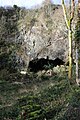
 Higher Kiln Quarry Caves - geograph.org.uk - 1097485.jpg 640 × 427; 120 KB
-
 Higher Kiln Quarry Caves - geograph.org.uk - 1097493.jpg 640 × 427; 131 KB
-
 Higher Kiln Quarry Caves, Buckfastleigh - geograph.org.uk - 1137038.jpg 427 × 640; 125 KB
-
 Higher Shapter Street - geograph.org.uk - 1179601.jpg 427 × 640; 84 KB
-
 Hillards Bridge, Ballyard - geograph.org.uk - 1398762.jpg 640 × 427; 39 KB
-
 Holy Trinity Church, Buckfastleigh - geograph.org.uk - 1222240.jpg 427 × 640; 122 KB
-
 Holy Trinity Church, Buckfastleigh - geograph.org.uk - 1222286.jpg 427 × 640; 85 KB
-
 Holy Trinity Churchyard - geograph.org.uk - 1097578.jpg 427 × 640; 104 KB
-
 Holy Trinity Churchyard, Buckfastleigh - geograph.org.uk - 1222261.jpg 640 × 427; 130 KB
-

-

-

-
 Horsebrook Cottages, Avonwick - geograph.org.uk - 1066401.jpg 640 × 427; 99 KB
-
 Horsepool Lodge on the Boconnoc Estate - geograph.org.uk - 1139944.jpg 640 × 427; 102 KB
-
 House Sparrow - geograph.org.uk - 1160340.jpg 640 × 427; 57 KB
-

-

-

-
 Insole Court, Llandaff - geograph.org.uk - 1258054.jpg 640 × 427; 94 KB
-
 Insole Grove, Llandaff - geograph.org.uk - 1257583.jpg 640 × 427; 96 KB
-

-

-
 Kerries Lane, South Brent - geograph.org.uk - 1149411.jpg 427 × 640; 63 KB
-
 Kerries Road, South Brent - geograph.org.uk - 1149148.jpg 427 × 640; 93 KB
-
 Kerries Road, South Brent - geograph.org.uk - 1149170.jpg 640 × 427; 93 KB
-
 Killelton, on Tralee Bay - geograph.org.uk - 1370154.jpg 640 × 427; 56 KB
-
 Ladies View - geograph.org.uk - 1478815.jpg 640 × 427; 75 KB
-
 Ladies Wood Nature Reserve - geograph.org.uk - 933594.jpg 640 × 480; 81 KB
-
 Ladies Wood, South Brent - geograph.org.uk - 1716066.jpg 1,024 × 768; 367 KB
-
 Lane near Owley - geograph.org.uk - 933657.jpg 640 × 480; 147 KB
-
 Lane near Tawlaght - geograph.org.uk - 1418415.jpg 640 × 427; 75 KB

.jpg)


.jpg)


.jpg)


