Category:Im Hinteren Eis
Jump to navigation
Jump to search
mountain at the Ötztal Alps at the border Tyrol / South Tyrol  | |||||
| Upload media | |||||
| Instance of | |||||
|---|---|---|---|---|---|
| Location | |||||
| Mountain range | |||||
| Topographic isolation |
| ||||
| Elevation above sea level |
| ||||
 | |||||
Deutsch: Im Hinteren Eis ist ein Berg der Ötztaler Alpen auf der Grenze zwischen Tirol, Österreich und Südtirol, Italien.
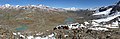
English: Im Hinteren Eis is a mountain of the Ötztal Alps on the border between Tyrol, Austria and South Tyrol, Italy.
Media in category "Im Hinteren Eis"
The following 8 files are in this category, out of 8 total.
-
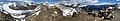 360-Grad-Panorama Im Hinteren Eis.jpg 23,552 × 4,211; 23.19 MB
-
 Hochjoch Schöne-Aussicht-Hütte Im Hinteren Eis.jpg 4,000 × 3,000; 4.76 MB
-
 Hochjoch von unterhalb der Grawand.jpg 10,138 × 3,299; 8.73 MB
-
 Im Hinteren Eis Gipfel.jpg 4,000 × 3,000; 4.7 MB
-
 Im Hinteren Eis Kurzras.jpg 4,000 × 3,000; 4.37 MB
-
 Im Hinteren Eis Panorama.jpg 16,880 × 2,048; 6.58 MB
-
 Im hinteren Eis.JPG 3,072 × 4,608; 7.47 MB
-
 Val Senales banner.jpg 14,327 × 2,048; 5.4 MB


