Category:Igreja de São Sebastião (Serra d’El-Rei)
Jump to navigation
Jump to search
| Object location | | View all coordinates using: OpenStreetMap |
|---|
| This building is classified as Sem proteção legal .It is indexed in the SIPA database (Sistema de Informação para o Património Arquitetónico) under the reference 1744. |
.jpg) | |||||
| Upload media | |||||
| Instance of | |||||
|---|---|---|---|---|---|
| Location | Serra d'El-Rei, Peniche, Leiria, Portugal | ||||
| Heritage designation | |||||
 | |||||
Media in category "Igreja de São Sebastião (Serra d’El-Rei)"
The following 7 files are in this category, out of 7 total.
-
 Fachada lateral esquerda da Igreja Paroquial de Serra d'El-Rei.jpg 4,000 × 3,000; 4.36 MB
-
 Fachada tardoz da Igreja Paroquial de Serra d'El-Rei.jpg 3,000 × 4,000; 4.34 MB
-
 Frente da Igreja Paroquial de Serra d'El-Rei.jpg 3,000 × 4,000; 4.36 MB
-
 Igreja Matriz de Serra d'El-Rei - Portugal (20248055879).jpg 3,888 × 2,592; 1.85 MB
-
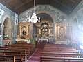
 Serra-church1.jpg 1,600 × 1,200; 292 KB
-
 Serra-church2.jpg 1,600 × 1,200; 341 KB
-
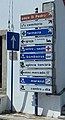 Tabuletas@SdER.jpg 533 × 988; 243 KB


