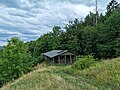
Category:Hut near the main peak of Hoher Dörnberg at the foodpath to Helfensteine
Jump to navigation
Jump to search
| Camera location | | View all coordinates using: OpenStreetMap |
|---|
Media in category "Hut near the main peak of Hoher Dörnberg at the foodpath to Helfensteine"
The following 20 files are in this category, out of 20 total.
-

-
 213 Hütte nahe dem Hauptgipfel des Hohen Dörnbergs am Fußweg zu den zu den Helfensteinen.jpg 9,248 × 6,936; 17.51 MB
-

-
-
-

-
-
 221 Hütte nahe dem Hauptgipfel des Hohen Dörnbergs am Fußweg zu den Helfensteinen.jpg 9,248 × 6,936; 18.88 MB
-

-

-

-

-
 226 Hütte nahe dem Hauptgipfel des Hohen Dörnbergs am Fußweg zu den Helfensteinen.jpg 9,248 × 6,936; 14.78 MB
-

-

-
 229 Hütte nahe dem Hauptgipfel des Hohen Dörnbergs am Fußweg zu den Helfensteinen.jpg 9,248 × 6,936; 15.67 MB
-

-
 231 Hütte nahe dem Hauptgipfel des Hohen Dörnbergs am Fußweg zu den Helfensteinen.jpg 9,248 × 6,936; 14.83 MB
-
 232 Hütte nahe dem Hauptgipfel des Hohen Dörnbergs am Fußweg zu den Helfensteinen.jpg 9,248 × 6,936; 12.06 MB
-
 Schutzhütte Immelburg.JPG 3,264 × 2,448; 3.05 MB


_an_der_H%C3%BCtte_nahe_dem_Hauptgipfel_des_Hohen_D%C3%B6rnbergs_am_Fu%C3%9Fweg_zu_den_Helfensteinen.jpg)
,_Rundbl%C3%A4ttrige_Glockenblume_(Campanula_rotundifolia)_und_Hufeisenklee_(Hippocrepis_comosa)_an_der_H%C3%BCtte_nahe_dem_Hauptgipfel_des_Hohen_D%C3%B6rnbergs_am_Fu%C3%9Fweg_zu_den_Helfensteine.jpg)

_und_Gew%C3%B6hnlicher_Natternkopf_(Echium_vulgare)_an_der_H%C3%BCtte_nahe_dem_Hauptgipfel_des_Hohen_D%C3%B6rnbergs_am_Fu%C3%9Fweg_zu_den_zu_den_Helfensteinen.jpg)


