Category:Hurricane Hazel
Jump to navigation
Jump to search
Category 4 Atlantic hurricane in 1954 | |||||
| Upload media | |||||
| Instance of | |||||
|---|---|---|---|---|---|
| Location |
| ||||
| Start time |
| ||||
| End time |
| ||||
| |||||
Subcategories
This category has the following 3 subcategories, out of 3 total.
M
- Hurricane Hazel maps (4 F)
R
- Raymore Drive, Toronto (1 P, 10 F)
Media in category "Hurricane Hazel"
The following 18 files are in this category, out of 18 total.
-
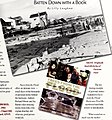
 Coast watch (1979) (20038183303).jpg 2,624 × 1,286; 1,015 KB
-
 Coast watch (1979) (20470947320).jpg 2,722 × 1,410; 1.29 MB
-
 Coast watch (1979) (20474259199).jpg 2,024 × 2,160; 1.18 MB
-

-
 Don R. (West Don R.), looking north across Yonge St. bridge (30040304340).jpg 1,920 × 1,259; 607 KB
-
 Humber Weir.JPG 4,288 × 2,848; 3.07 MB
-
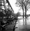 Hurricane Hazel -- Albion bridge.jpg 606 × 620; 63 KB
-
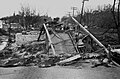
 Hurricane Hazel -- debris.jpg 824 × 800; 122 KB
-
 Hurricane Hazel -- house1.jpg 738 × 734; 37 KB
-
 Hurricane Hazel -- house2.jpg 736 × 715; 66 KB
-
 Hurricane Hazel -- Lawrence Avenue.jpg 930 × 429; 51 KB
-
 Hurricane Hazel -- October 15, 1954 (4893181009).jpg 2,115 × 1,586; 646 KB
-
 Hurricane Hazel -- St.Phillips Road.jpg 933 × 866; 86 KB
-
 Hurricane Hazel -- washed-out.road.jpg 823 × 798; 63 KB
-
 Hurricane Hazel -- Weston Golf Club.jpg 930 × 898; 56 KB
-
 Hurricane Hazel.jpg 526 × 495; 87 KB
-
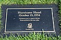 Plaque for Hurricane Hazel.jpg 640 × 427; 188 KB
-
 View of seas blown up during Hurricane Hazel in October 1954.jpg 5,695 × 4,559; 11.13 MB
_(20038183303).jpg)
_(20470947320).jpg)
_(20474259199).jpg)

,_looking_north_across_Yonge_St._bridge_(30040304340).jpg)


.jpg)


