Category:Hungarton
Jump to navigation
Jump to search
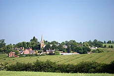
English: Hungarton (or Hungerton) is a small village in the county of Leicestershire, England. It is located approximately 10 miles (16 km) from the city of Leicester. The name Hungarton is believed to have come from the Old English "Hungry tun" meaning Hungry town, it was called this because the quality of the soil in the area was so poor.
village and civil parish in Leicestershire, UK | |||||
| Upload media | |||||
| Instance of | |||||
|---|---|---|---|---|---|
| Location | Harborough, Leicestershire, East Midlands, England | ||||
| Population |
| ||||
| Area |
| ||||
 | |||||
Subcategories
This category has the following 5 subcategories, out of 5 total.
Media in category "Hungarton"
The following 200 files are in this category, out of 273 total.
(previous page) (next page)-
'Monk's Grave' motte - geograph.org.uk - 6423618.jpg 3,776 × 2,520; 3.18 MB
-
Along Main Street in Hungarton - geograph.org.uk - 762315.jpg 640 × 449; 102 KB
-
Ancient tree along Ingarsby Lane - geograph.org.uk - 3814633.jpg 1,357 × 1,600; 1,000 KB
-
Approaching the entrance to Cold Newton Lodge - geograph.org.uk - 6418552.jpg 3,776 × 2,520; 4.11 MB
-
Ashby House Farmhouse, Hungarton - geograph.org.uk - 5730645.jpg 1,280 × 960; 414 KB
-
Autumn along Ingarsby Lane - geograph.org.uk - 3227829.jpg 4,000 × 3,000; 3.57 MB
-
Autumn colours along Ingarsby Lane - geograph.org.uk - 3227827.jpg 3,309 × 2,523; 2.49 MB
-
Baggrave Road towards Hungarton - geograph.org.uk - 762337.jpg 640 × 444; 105 KB
-
Bagrave Road at the junction to Bagrave Park - geograph.org.uk - 6221092.jpg 3,776 × 2,520; 3.34 MB
-
Barley Leas leading off Ingarsby Road - geograph.org.uk - 6221291.jpg 3,776 × 2,520; 4.05 MB
-
Barley Leas past Brook Farm Cottage - geograph.org.uk - 6221285.jpg 3,776 × 2,520; 3.18 MB
-
Barley Leas towards Hungarton - geograph.org.uk - 5097558.jpg 640 × 466; 97 KB
-
Barley Leas towards Hungarton - geograph.org.uk - 6488743.jpg 800 × 450; 142 KB
-
Barley Leas towards Old Ingarsby - geograph.org.uk - 5097559.jpg 640 × 485; 123 KB
-
Bench mark, former railway bridge near Ingarsby - geograph.org.uk - 5731729.jpg 1,280 × 1,280; 573 KB
-
Bench mark, Rose Cottage, Main Street, Hungarton - geograph.org.uk - 5730713.jpg 1,280 × 1,280; 269 KB
-
Bench on the driveway to Quenby Hall - geograph.org.uk - 3814674.jpg 1,600 × 1,199; 335 KB
-
Bends on Barley Leas - geograph.org.uk - 5731720.jpg 1,280 × 960; 457 KB
-
Beside Hungarton Park - geograph.org.uk - 6827806.jpg 768 × 1,024; 202 KB
-
Beside Waterloo Lodge Farm - geograph.org.uk - 6827811.jpg 1,024 × 768; 163 KB
-
Bluebell Cottage, Hungarton - geograph.org.uk - 5730671.jpg 1,280 × 1,280; 469 KB
-
Bluebell Cottage, Hungarton – datestone - geograph.org.uk - 5730676.jpg 1,280 × 1,280; 507 KB
-
Bridleway along a ridge in High Leicestershire - geograph.org.uk - 6221198.jpg 3,776 × 2,520; 3.15 MB
-
Bridleway along Ingarsby Lane - geograph.org.uk - 4319620.jpg 1,600 × 1,200; 622 KB
-
Bridleway approaching Quenby Hall from the east - geograph.org.uk - 6221234.jpg 3,776 × 2,520; 4.08 MB
-
Bridleway crossing the site of the deserted village of Ingarsby (geograph 6484894).jpg 3,776 × 2,520; 3.8 MB
-
Bridleway track to Cold Newton Lodge - geograph.org.uk - 6418530.jpg 3,776 × 2,520; 4.09 MB
-
Brook Cottage, Church Lane, Hungarton - geograph.org.uk - 5730643.jpg 1,280 × 960; 534 KB
-
Brook Farm Cottage along Barley Leas - geograph.org.uk - 3814644.jpg 1,600 × 1,492; 717 KB
-
Brook Farm Cottage on Barley Leas - geograph.org.uk - 3236362.jpg 3,506 × 2,684; 1.62 MB
-
Carr Bridge (geograph 7408930).jpg 1,024 × 768; 342 KB
-
Carr Bridge from downstream - geograph.org.uk - 4931606.jpg 640 × 430; 126 KB
-
Cattle grid - geograph.org.uk - 6285880.jpg 1,600 × 900; 334 KB
-
Cattle grid in Baggrave Park - geograph.org.uk - 6771951.jpg 1,600 × 1,116; 146 KB
-
Cattle grid repairs - geograph.org.uk - 3578543.jpg 640 × 470; 35 KB
-
Cattle grid repairs - geograph.org.uk - 3578544.jpg 640 × 459; 31 KB
-
Church Lane, Hungarton - geograph.org.uk - 4877645.jpg 640 × 640; 88 KB
-
Church View, Church Lane, Hungarton - geograph.org.uk - 5730654.jpg 1,280 × 960; 407 KB
-
Close up of gates along Cold Newton Road - geograph.org.uk - 4284108.jpg 1,600 × 1,200; 351 KB
-
Cold Newton Lodge - geograph.org.uk - 5099334.jpg 640 × 480; 130 KB
-
Comma butterfly - geograph.org.uk - 4319788.jpg 1,600 × 1,149; 402 KB
-
Corner of a field - geograph.org.uk - 5119682.jpg 640 × 478; 105 KB
-
Country lane near Ingarsby Lodge - geograph.org.uk - 6724503.jpg 800 × 566; 128 KB
-
Country Road leading to Tilton Lane - geograph.org.uk - 4321162.jpg 1,600 × 1,058; 611 KB
-
Countryside east of Old Ingarsby - geograph.org.uk - 4319764.jpg 1,600 × 1,075; 417 KB
-
Countryside near Hungarton - geograph.org.uk - 762349.jpg 640 × 517; 97 KB
-
Countryside of the Leicestershire Wolds - geograph.org.uk - 1139914.jpg 640 × 480; 171 KB
-
Dandelion clocks - geograph.org.uk - 6484896.jpg 3,776 × 2,520; 3.15 MB
-
Datestone, Old Farmhouse, Hungarton - geograph.org.uk - 5720200.jpg 1,280 × 960; 374 KB
-
Datestone, Sycamore Farmhouse, Hungarton - geograph.org.uk - 5720204.jpg 1,280 × 960; 271 KB
-
Disused railway bridge over Ingarsby Lane - geograph.org.uk - 5731730.jpg 1,280 × 960; 558 KB
-
Driveway from Quenby Hall crossing a shallow ditch - geograph.org.uk - 6221257.jpg 3,776 × 2,520; 4.26 MB
-
Driveway to Cold Newton Lodge - geograph.org.uk - 4434202.jpg 640 × 427; 88 KB
-
Driveway to Hungarton Park - geograph.org.uk - 4877660.jpg 640 × 640; 138 KB
-
Driveway to Inkerman Lodge - geograph.org.uk - 762414.jpg 640 × 506; 95 KB
-
Enjoying a break - geograph.org.uk - 5730732.jpg 1,280 × 960; 353 KB
-
Entering Hungarton - geograph.org.uk - 6827805.jpg 768 × 1,024; 205 KB
-
Entering Hungarton on Baggrave Road - geograph.org.uk - 6220272.jpg 3,776 × 2,520; 4.31 MB
-
Entering New Covert - geograph.org.uk - 6827772.jpg 768 × 1,024; 353 KB
-
Entrance to Byway near Hungarton - geograph.org.uk - 4877657.jpg 640 × 640; 107 KB
-
Fallen tree in Baggrave Park - geograph.org.uk - 6771952.jpg 1,600 × 1,114; 159 KB
-
Fallen tree next to the footpath - geograph.org.uk - 4319696.jpg 1,600 × 1,100; 628 KB
-
Farmland near Hungarton Park - geograph.org.uk - 6632629.jpg 800 × 450; 152 KB
-
Farmland near Ingarsby Lodge - geograph.org.uk - 6724505.jpg 800 × 509; 127 KB
-
Farmland north of Botany Bay Fox Covert - geograph.org.uk - 4321186.jpg 1,600 × 1,082; 599 KB
-
Farmland north of Old Ingarsby - geograph.org.uk - 3236337.jpg 3,104 × 2,327; 2.33 MB
-
Farmland south of Hungarton - geograph.org.uk - 6488740.jpg 800 × 450; 114 KB
-
Field and gate near Monk's Grave motte - geograph.org.uk - 4317555.jpg 1,600 × 1,137; 480 KB
-
Field and hedge near Botany Bay Fox Covert - geograph.org.uk - 4319781.jpg 1,200 × 1,600; 744 KB
-
Field and hedge near Old Ingarsby - geograph.org.uk - 4319687.jpg 1,600 × 1,181; 516 KB
-
Field and trees near Old Ingarsby - geograph.org.uk - 4319667.jpg 1,600 × 1,200; 679 KB
-
Field Path - geograph.org.uk - 6827809.jpg 1,024 × 768; 116 KB
-
Fields near Old Ingarsby - geograph.org.uk - 4319711.jpg 1,600 × 1,166; 589 KB
-
Fly tipping along Ingarsby Lane - geograph.org.uk - 3814603.jpg 1,600 × 1,210; 716 KB
-
Footbridge at Hungarton - geograph.org.uk - 5730689.jpg 1,280 × 948; 579 KB
-
Footpath crossroads near Hungarton - geograph.org.uk - 5730677.jpg 960 × 1,280; 683 KB
-
Footpath to Hungarton - geograph.org.uk - 5730734.jpg 1,280 × 960; 307 KB
-
Footpath towards Hungarton - geograph.org.uk - 3277282.jpg 640 × 462; 51 KB
-
Ford at Old Ingarsby - geograph.org.uk - 2812223.jpg 3,872 × 2,592; 2.47 MB
-
Ford on the path to the site of Quenby - geograph.org.uk - 2812226.jpg 3,872 × 2,592; 2.5 MB
-
Former station house, Ingarsby - geograph.org.uk - 5731734.jpg 1,280 × 960; 544 KB
-
Fox Holes Spinney - geograph.org.uk - 3236389.jpg 2,991 × 2,509; 2.18 MB
-
Gate and bridleway - geograph.org.uk - 4319653.jpg 1,600 × 1,200; 514 KB
-
Gate and farm track along Cold Newton Road - geograph.org.uk - 4284101.jpg 1,600 × 1,128; 378 KB
-
Gate and farmland near Hungarton - geograph.org.uk - 6421932.jpg 800 × 494; 125 KB
-
Gate and waypost on track to Ingarsby - geograph.org.uk - 1810351.jpg 640 × 480; 107 KB
-
Gate on to land of the Quenby Estate - geograph.org.uk - 6418594.jpg 3,776 × 2,520; 3.95 MB
-
Gates along Ingarsby Lane - geograph.org.uk - 3814563.jpg 1,600 × 1,200; 638 KB
-
Gateway to Carr Bridge - geograph.org.uk - 4931611.jpg 640 × 470; 149 KB
-
Grassland near Hungarton Lodge - geograph.org.uk - 4877662.jpg 640 × 640; 85 KB
-
Gravestones - geograph.org.uk - 149685.jpg 640 × 522; 129 KB
-
Grazing sheep near Ingarsby Hollow - geograph.org.uk - 3814592.jpg 1,600 × 1,179; 418 KB
-
Hawthorn in May - geograph.org.uk - 6484905.jpg 3,776 × 2,520; 4.3 MB
-
Hedge next to Botany Bay Fox Covert - geograph.org.uk - 4321154.jpg 1,600 × 1,140; 667 KB
-
Herd of cows near Billesdon Coplow - geograph.org.uk - 4322204.jpg 1,600 × 1,141; 646 KB
-
Hope Farmhouse, Hungarton - geograph.org.uk - 5730707.jpg 1,280 × 858; 487 KB
-
Hungarton eighteenth-century house.jpg 1,339 × 2,000; 754 KB
-
Hungarton from Quenby Hall entrance.jpg 2,000 × 1,339; 901 KB
-
Hungarton LE7, UK - panoramio.jpg 9,728 × 4,864; 12.08 MB
-
Hungarton Park - geograph.org.uk - 4877664.jpg 640 × 640; 98 KB
-
Hungarton ridge and furrow.jpg 2,000 × 1,339; 762 KB
-
Hungarton Road - geograph.org.uk - 2607510.jpg 640 × 473; 71 KB
-
Hungarton Road-Park Road junction. - geograph.org.uk - 2607511.jpg 640 × 574; 130 KB
-
Hungarton village - geograph.org.uk - 5730686.jpg 1,280 × 960; 343 KB
-
Hungarton Village, Leicestershire - geograph.org.uk - 518749.jpg 640 × 488; 118 KB
-
Ingarsby deserted medieval village - geograph.org.uk - 5731763.jpg 1,280 × 960; 402 KB
-
Ingarsby deserted medieval village - geograph.org.uk - 5731770.jpg 1,280 × 960; 532 KB
-
Ingarsby deserted medieval village - geograph.org.uk - 5731773.jpg 1,280 × 960; 532 KB
-
Ingarsby deserted medieval village - geograph.org.uk - 5731777.jpg 1,280 × 960; 428 KB
-
Ingarsby deserted medieval village - geograph.org.uk - 5731782.jpg 1,280 × 960; 348 KB
-
Ingarsby deserted medieval village - geograph.org.uk - 5731794.jpg 1,280 × 960; 392 KB
-
Ingarsby deserted medieval village - geograph.org.uk - 5731797.jpg 1,280 × 960; 416 KB
-
Ingarsby deserted medieval village - geograph.org.uk - 5731799.jpg 1,280 × 960; 514 KB
-
Ingarsby deserted medieval village - geograph.org.uk - 5731800.jpg 1,280 × 960; 484 KB
-
Ingarsby deserted medieval village - geograph.org.uk - 5731805.jpg 1,280 × 960; 454 KB
-
Ingarsby deserted medieval village - geograph.org.uk - 5731806.jpg 1,280 × 960; 449 KB
-
Ingarsby deserted medieval village - geograph.org.uk - 5731812.jpg 1,280 × 960; 336 KB
-
Ingarsby deserted medieval village - geograph.org.uk - 5731844.jpg 1,280 × 960; 342 KB
-
Ingarsby deserted medieval village - geograph.org.uk - 5731850.jpg 1,280 × 960; 592 KB
-
Ingarsby Hollow - geograph.org.uk - 3227825.jpg 4,000 × 3,000; 1.87 MB
-
Ingarsby Lane - geograph.org.uk - 5731814.jpg 1,280 × 960; 625 KB
-
Ingarsby Lane at Old Ingarsby - geograph.org.uk - 3229293.jpg 4,000 × 3,000; 3.27 MB
-
Ingarsby Lane crossing a tributary to Melton Brook - geograph.org.uk - 6420301.jpg 3,776 × 2,520; 3.08 MB
-
Ingarsby Lane near Old Ingarsby - geograph.org.uk - 3229310.jpg 4,000 × 3,000; 4.76 MB
-
Ingarsby Lane, north from Houghton on the Hill - geograph.org.uk - 6484878.jpg 3,776 × 2,520; 3.84 MB
-
Ingarsby Lodge, White House Farm - geograph.org.uk - 6418577.jpg 3,776 × 2,520; 3.97 MB
-
Ingarsby Old Hall - geograph.org.uk - 6420257.jpg 3,776 × 2,520; 3.03 MB
-
Ingarsby railway viaduct - geograph.org.uk - 5731809.jpg 1,280 × 960; 498 KB
-
Ingarsby Train Station - geograph.org.uk - 5731739.jpg 1,280 × 960; 459 KB
-
Ivy along Ingarsby Road - geograph.org.uk - 3236394.jpg 4,000 × 3,000; 3.41 MB
-
Knobbly tree along Ingarsby Lane - geograph.org.uk - 3227756.jpg 2,894 × 2,233; 2.13 MB
-
Landscape with ash branch - geograph.org.uk - 5730626.jpg 960 × 1,280; 391 KB
-
Lane to Old Ingarsby and Keyham - geograph.org.uk - 4321203.jpg 1,600 × 1,200; 629 KB
-
Leicestershire countryside near Old Ingarsby - geograph.org.uk - 4319725.jpg 1,600 × 1,132; 598 KB
-
Leicestershire farmland near Hungarton - geograph.org.uk - 6724500.jpg 800 × 585; 102 KB
-
Lilac Cottage, Hungarton - geograph.org.uk - 5730695.jpg 1,280 × 960; 384 KB
-
Lilac Cottage, Hungarton - geograph.org.uk - 5730722.jpg 1,280 × 960; 358 KB
-
Lilac Cottage, Hungarton – datestone - geograph.org.uk - 5730699.jpg 1,280 × 1,280; 438 KB
-
Lilac Cottage, Hungarton – datestone - geograph.org.uk - 5730726.jpg 1,280 × 1,280; 413 KB
-
Line to nowhere - geograph.org.uk - 4877637.jpg 640 × 640; 149 KB
-
Lone horse in a field at Hungarton - geograph.org.uk - 6724507.jpg 800 × 640; 78 KB
-
Main Street in Hungarton - geograph.org.uk - 762290.jpg 640 × 484; 95 KB
-
Main Street in Hungarton - geograph.org.uk - 762298.jpg 640 × 491; 83 KB
-
Main Street in Hungarton - geograph.org.uk - 762312.jpg 640 × 504; 101 KB
-
Main Street, Hungarton - geograph.org.uk - 5730710.jpg 1,280 × 960; 274 KB
-
Medieval motte and deserted village, Ingarsby - geograph.org.uk - 5731840.jpg 1,280 × 960; 371 KB
-
Medieval motte, Ingarsby - geograph.org.uk - 5731830.jpg 1,280 × 960; 537 KB
-
Medieval motte, Ingarsby - geograph.org.uk - 5731834.jpg 1,280 × 960; 617 KB
-
Midshires Way crosses Carr Bridge - geograph.org.uk - 4931612.jpg 640 × 449; 120 KB
-
Midshires Way towards Ashby Folville - geograph.org.uk - 4931613.jpg 640 × 462; 108 KB
-
Midshires Way towards Cold Newton - geograph.org.uk - 4931614.jpg 640 × 442; 105 KB
-
Monk's Grave Motte - geograph.org.uk - 5473943.jpg 800 × 539; 157 KB
-
Near Botany Bay Fox Covert - geograph.org.uk - 1810346.jpg 640 × 480; 65 KB
-
Neither use nor ornament - geograph.org.uk - 4877643.jpg 640 × 640; 145 KB
-
No access for motor vehicles - geograph.org.uk - 5731791.jpg 1,280 × 960; 377 KB
-
Old Farmhouse*, Hungarton - geograph.org.uk - 5720199.jpg 1,280 × 960; 274 KB
-
On a public access route south-east of Old Ingarsby - geograph.org.uk - 6484902.jpg 3,776 × 2,520; 3.91 MB
-
Outbuilding at Old Farmhouse - geograph.org.uk - 5720209.jpg 1,280 × 960; 387 KB
-
Pasture land along Ingarsby Road - geograph.org.uk - 3236382.jpg 2,548 × 2,271; 2.01 MB
-
Path heading east towards Botany Bay Fox Covert - geograph.org.uk - 4319754.jpg 1,600 × 1,109; 566 KB
-
Path heading east towards Botany Bay Fox Covert - geograph.org.uk - 4319771.jpg 1,600 × 1,153; 664 KB
-
Path heading west past Botany Bay Fox Covert - geograph.org.uk - 4321166.jpg 1,600 × 1,050; 488 KB
-
Path leading east past Botany Bay Fox Covert - geograph.org.uk - 4321158.jpg 1,456 × 1,600; 654 KB
-
Path towards Quenby Lodge - geograph.org.uk - 4877647.jpg 640 × 640; 144 KB
-
Path towards Quenby Lodge - geograph.org.uk - 4877649.jpg 640 × 640; 110 KB
-
Path towards Quenby Lodge - geograph.org.uk - 4877651.jpg 640 × 640; 97 KB
-
Path towards Quenby Lodge - geograph.org.uk - 4877652.jpg 640 × 640; 167 KB
-
Path towards Quenby Lodge - geograph.org.uk - 4877653.jpg 640 × 640; 52 KB
-
Path towards Quenby Lodge - geograph.org.uk - 4877655.jpg 640 × 640; 117 KB
-
Path towards Quenby Lodge - geograph.org.uk - 4877656.jpg 640 × 640; 174 KB
-
Path towards Waterloo Farm - geograph.org.uk - 4877665.jpg 640 × 640; 114 KB
-
Path towards Waterloo Farm - geograph.org.uk - 4877667.jpg 640 × 640; 122 KB
-
Path towards Waterloo Farm - geograph.org.uk - 4877669.jpg 640 × 640; 87 KB
-
Pathway close to Hungarton - geograph.org.uk - 6827808.jpg 768 × 1,024; 214 KB
-
Pear Tree Cottage, Hungarton - geograph.org.uk - 5730697.jpg 1,280 × 1,280; 456 KB
-
Plaque outside Ingarsby Old Hall - geograph.org.uk - 3227834.jpg 3,000 × 4,000; 3.35 MB
-
Pond by driveway to Cold Newton Lodge - geograph.org.uk - 4434203.jpg 640 × 470; 118 KB
-
Postbox in Old Ingarsby - geograph.org.uk - 3229318.jpg 4,000 × 3,000; 3.54 MB
-
Primula and polyanthus, Main Street, Hungarton - geograph.org.uk - 5730718.jpg 1,280 × 960; 601 KB
-
Private drive to Cold Newton Lodge - geograph.org.uk - 4321202.jpg 1,600 × 1,084; 657 KB
-
Public Access Route near Ingarsby - geograph.org.uk - 5731786.jpg 960 × 1,280; 475 KB
-
Public Access Route near Ingarsby - geograph.org.uk - 5731821.jpg 1,280 × 960; 612 KB
-
Public Access Route near Ingarsby - geograph.org.uk - 5731853.jpg 960 × 1,280; 767 KB
-
Public access route near Waterloo Lodge Farm - geograph.org.uk - 5720087.jpg 1,280 × 960; 610 KB
-
Public bridleway heading east across the fields - geograph.org.uk - 4319661.jpg 1,600 × 1,153; 560 KB
-
Public bridleway to Hungarton - geograph.org.uk - 762396.jpg 640 × 444; 78 KB
-
Public footpath marker along Covert Lane - geograph.org.uk - 5473929.jpg 800 × 659; 164 KB
-
Public footpath to South Croxton - geograph.org.uk - 762140.jpg 565 × 640; 124 KB
-
Public footpath to South Croxton - geograph.org.uk - 762343.jpg 640 × 480; 92 KB
-
Quenby Lodge (geograph 6221214).jpg 2,183 × 1,288; 436 KB
-
Queniborough Brook - geograph.org.uk - 4931615.jpg 640 × 426; 144 KB
-
Railway bridge abutment, Old Ingarsby - geograph.org.uk - 6418615.jpg 3,776 × 2,520; 4.17 MB
-
Remains of railway bridge near Ingarsby - geograph.org.uk - 5731723.jpg 1,280 × 960; 560 KB
-
Road heading away from Waterloo Farm - geograph.org.uk - 4877672.jpg 640 × 640; 76 KB
-
Road leaving Baggrave Park - geograph.org.uk - 6221186.jpg 3,776 × 2,520; 3.01 MB
-
Road to Hungarton - geograph.org.uk - 4877659.jpg 640 × 640; 166 KB
-
Road towards Hungarton - geograph.org.uk - 4877674.jpg 640 × 640; 129 KB
-
Road towards Hungarton - geograph.org.uk - 4877675.jpg 640 × 640; 128 KB


