Category:Hulstkamp Gebouw (Rotterdam)
Jump to navigation
Jump to search
| Object location | | View all coordinates using: OpenStreetMap |
|---|
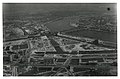
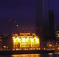
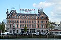
Nederlands: Afbeeldingen van het Hulstkamp-gebouw, Maaskade 119, 3071 NK Rotterdam. Gelegen in de wijk Noordereiland behorende tot het stadskwartier Feijenoord in de gemeente Rotterdam in de provincie Zuid-Holland in het westen van Nederland. Het is een rijksmonument
|
This is a category about rijksmonument number 513924
|
Nederlands: , Maaskade (Rotterdam), Noordereiland (Rotterdam), Feijenoord (stadsdeel), Rotterdam, Zuid-Holland, Nederland
 | |||||
| Upload media | |||||
| Instance of | |||||
|---|---|---|---|---|---|
| Location | Rotterdam, South Holland, Netherlands | ||||
| Street address |
| ||||
| Architectural style | |||||
| Architect | |||||
| Heritage designation |
| ||||
 | |||||
Subcategories
This category has only the following subcategory.
Media in category "Hulstkamp Gebouw (Rotterdam)"
The following 23 files are in this category, out of 23 total.
-
-

-

-
-

-

-

-

-
 Hulstkamp - Rotterdam - 2009 - panoramio.jpg 2,281 × 2,193; 350 KB
-
 Hulstkamp building Rotterdam.jpg 4,928 × 3,264; 7.02 MB
-

-

-

-
 Maaskade hoek Sleephellingstraat, 1946.jpg 1,600 × 1,046; 500 KB
-
 Maaskade Rotterdam, 2011.jpg 3,458 × 1,318; 3.22 MB
-

-

-
 Noordereiland Rotterdam 2018.jpg 4,928 × 3,264; 5.79 MB
-
 Rotterdam maaskade119.jpg 2,657 × 2,193; 771 KB
-

-

-

-


