Category:Hulshofs Verenigde Fabrieken (Lichtenvoorde)
Jump to navigation
Jump to search
| Object location | | View all coordinates using: OpenStreetMap |
|---|
 | |||||
| Upload media | |||||
| Instance of | |||||
|---|---|---|---|---|---|
| Location | Lichtenvoorde, Oost Gelre, Gelderland, Netherlands | ||||
| Street address |
| ||||
| Located on street |
| ||||
| Heritage designation |
| ||||
 | |||||
|
This is a category about rijksmonument number 516286
|
| Address |
|
Media in category "Hulshofs Verenigde Fabrieken (Lichtenvoorde)"
The following 4 files are in this category, out of 4 total.
-
 Exterieur OVERZICHT VOORGEVEL - Lichtenvoorde - 20339578 - RCE.jpg 1,183 × 1,200; 243 KB
-
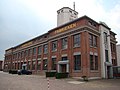 Hulshof lichtenvoorde 439.JPG 3,264 × 2,448; 2.51 MB
-
 Overzicht voorgevel en rechter zijgevel - Lichtenvoorde - 20359570 - RCE.jpg 1,200 × 944; 196 KB
-


