Category:Huis ter Does
Jump to navigation
Jump to search
| Object location | | View all coordinates using: OpenStreetMap |
|---|
archaeological site in Leiderdorp, Netherlands  | |||||
| Upload media | |||||
| Instance of | |||||
|---|---|---|---|---|---|
| Location | Leiderdorp, South Holland, Netherlands | ||||
| Street address |
| ||||
| Heritage designation |
| ||||
 | |||||
|
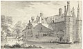
This is a category about rijksmonument number 45571
|
| Address |
|
Media in category "Huis ter Does"
The following 19 files are in this category, out of 19 total.
-
 1620, castle Huis Ter Does near Leiderdorp.png 4,032 × 2,532; 4.76 MB
-
 Atlas Schoemaker-ZUIDHOLLAND-DEEL2-1601-Zuid-Holland, Ter Does.jpeg 1,038 × 1,696; 305 KB
-
 Atlas Schoemaker-ZUIDHOLLAND-DEEL2-1603-Zuid-Holland, Does.jpeg 1,038 × 1,696; 328 KB
-

-

-

-

-

-
 Gezicht op Huis ter Does bij Leiderdorp, RP-T-1928-109.jpg 2,442 × 1,739; 432 KB
-
 Gezicht op Huis ter Does te Leiderdorp, RP-T-1992-76.jpg 6,560 × 4,372; 3.04 MB
-
 Gezicht op huis ter Does, gezien vanuit het noordoosten, RP-T-1891-A-2467.jpg 6,470 × 3,854; 4.1 MB
-
 Het huis ter Does (SM 3119z).png 6,831 × 4,804; 40.36 MB
-
 Het huis Ter Does bij Leiden, van achter gezien, RP-T-1894-A-2915.jpg 5,666 × 3,756; 4.34 MB
-
 Het huis Ter Does bij Leiden, van links gezien, RP-T-1894-A-2914.jpg 5,852 × 3,730; 3.79 MB
-
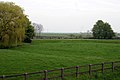 Leiderdorp - Locatie Kasteel Ter Does.jpg 3,072 × 2,048; 2.62 MB
-
 Netherlands, Leiderdorp, Huis ter Does 1.jpg 2,952 × 2,032; 1.81 MB
-

-
 Tekening Huis ter Does - Leiderdorp - 20137725 - RCE.jpg 1,200 × 933; 321 KB
-
 Tekening Huis ter Does - Leiderdorp - 20137726 - RCE.jpg 1,200 × 900; 302 KB


,_RP-P-AO-10-49F-3.jpg)
,_RP-P-AO-10-49F-4.jpg)
,_RP-P-OB-73.447.jpg)


.png)


,_in_bezit_van_Rijksdienst_voor_de_Monumenten_Zorg_-_Leiderdorp_-_20137727_-_RCE.jpg)

