Category:Huis Schouwenburg
Jump to navigation
Jump to search
| Object location | | View all coordinates using: OpenStreetMap |
|---|
farmhouse in Elburg, Netherlands  | |||||
| Upload media | |||||
| Instance of | |||||
|---|---|---|---|---|---|
| Part of | |||||
| Location | 't Harde, Elburg, Gelderland, Netherlands | ||||
| Street address |
| ||||
| Heritage designation |
| ||||
 | |||||
|
This is a category about rijksmonumentcomplex number 512065
|
Landhuis:
|
This is a category about rijksmonument number 512064
|
Historische aanleg:
|
This is a category about rijksmonument number 512066
|
Koetshuis:
|
This is a category about rijksmonument number 512067
|
Bijgebouw:
|
This is a category about rijksmonument number 512068
|
Trafohuisje:
|
This is a category about rijksmonument number 528128
|
| Address |
|
Subcategories
This category has only the following subcategory.
R
- Restoration of Huis Schouwenburg (15 F)
Media in category "Huis Schouwenburg"
The following 22 files are in this category, out of 22 total.
-
 A.11, achterzijde - Schouwenburg - 20198963 - RCE.jpg 1,200 × 808; 257 KB
-
 A.11, voorgevel - Schouwenburg - 20198964 - RCE.jpg 1,200 × 804; 218 KB
-
 A.12, boerderij - Schouwenburg - 20198965 - RCE.jpg 1,200 × 803; 315 KB
-
 Achtergevel met gedeelte van de vijver - Elburg - 20335661 - RCE.jpg 1,183 × 1,200; 345 KB
-
 Achtergevel met vijver - Elburg - 20335662 - RCE.jpg 1,192 × 1,200; 335 KB
-
 Detail van het plafond met stucwerk in grote zaal - Elburg - 20335676 - RCE.jpg 1,189 × 1,200; 168 KB
-
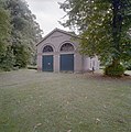
 Gevel van het koetshuis - Elburg - 20335663 - RCE.jpg 1,191 × 1,200; 383 KB
-
 Huis Schouwenburg A.11, koetshuis - Schouwenburg - 20198962 - RCE.jpg 1,200 × 810; 273 KB
-
 Ingangspartij - Elburg - 20335660 - RCE.jpg 1,193 × 1,200; 341 KB
-
 Landgoed Schouwenburg (31065322010).jpg 4,000 × 3,000; 3.81 MB
-
 Landgoed Schouwenburg (31398628496).jpg 4,000 × 3,000; 1.94 MB
-
 Landgoed Schouwenburg (31398631256).jpg 3,000 × 4,000; 4.85 MB
-
 Overzicht van het koetshuis - Elburg - 20335664 - RCE.jpg 1,188 × 1,200; 402 KB
-
 Schouwenburg-'t Harde (4).JPG 3,008 × 2,000; 1.26 MB
-
 Schouwenburg-'t Harde.JPG 2,000 × 3,008; 1.67 MB
-
 Tuinhuisje - Elburg - 20335666 - RCE.jpg 1,189 × 1,200; 394 KB
-

-

-

-
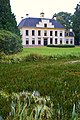
 Voorgevel landhuis - Elburg - 20335658 - RCE.jpg 1,193 × 1,200; 293 KB
-
 Voorgevel van landhuis - Elburg - 20335659 - RCE.jpg 1,194 × 1,200; 368 KB
-
 Zijgevel van het koetshuis met twee inrijpoorten - Elburg - 20335665 - RCE.jpg 1,187 × 1,200; 401 KB


.jpg)
.jpg)
.jpg)

.JPG)


