Category:Huis Rijnoord
Jump to navigation
Jump to search
| Object location | | View all coordinates using: OpenStreetMap |
|---|
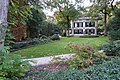
Monumental building in Woerden, the Netherlands  | |||||
| Upload media | |||||
| Instance of | |||||
|---|---|---|---|---|---|
| Part of |
| ||||
| Location | Woerden, Utrecht, Netherlands | ||||
| Street address |
| ||||
| Located on street | |||||
| Heritage designation |
| ||||
 | |||||
|
This is a category about rijksmonumentcomplex number 531014
|
Landhuis
|
This is a category about rijksmonument number 531015
|
Historische aanleg
|
This is a category about rijksmonument number 531016
|
Theekoepel
|
This is a category about rijksmonument number 531017
|
Entreehek
|
This is a category about rijksmonument number 531018
|
Tuinbeeld
|
This is a category about rijksmonument number 531019
|
| Address |
|
Subcategories
This category has only the following subcategory.
E
Media in category "Huis Rijnoord"
The following 14 files are in this category, out of 14 total.
-
 Aanzicht - Woerden - 20216369 - RCE.jpg 1,200 × 803; 252 KB
-
 Huis Rijnoord - IMG 20160627 192029490.jpg 4,160 × 2,340; 2.7 MB
-
 Huis Rijnoord-IMG 20160627 192114603.jpg 2,340 × 4,160; 1.73 MB
-
 Huis Rijnoord-IMG 20160627 192129818.jpg 2,340 × 4,160; 2.34 MB
-
 Huize Rijnoord 20141221-135736.jpg 3,264 × 2,448; 3.69 MB
-
 Huize Rijnoord 20141221-135800.jpg 4,496 × 1,024; 2.08 MB
-
 Landschapstuin Rijnoord Woerden, rijksmonument.jpg 5,472 × 3,648; 18.22 MB
-
 Met park - Woerden - 20216370 - RCE.jpg 1,200 × 809; 295 KB
-
 Rijksmonument-39299.jpg 1,024 × 1,280; 406 KB
-
 Theekoepel bij Rijnoord, Woerden. Rijksmonument 531017 (1).jpg 5,472 × 3,648; 12.25 MB
-
 Theekoepel bij Rijnoord, Woerden. Rijksmonument 531017 (2).jpg 5,472 × 3,648; 10.71 MB
-
 Woerden-rijnoord-046-1609 Woerden 039.jpg 3,882 × 2,387; 2.9 MB
-
 Woerden-rijnoord-047-1609 Woerden 041.jpg 3,648 × 3,648; 2.69 MB
-
 Woerden-rijnoord-049-1609 Woerden 042.jpg 3,648 × 5,472; 2.32 MB


.jpg)
.jpg)


