Category:Huis Landfort, Megchelen
Jump to navigation
Jump to search
| Object location | | View all coordinates using: OpenStreetMap |
|---|
 | |||||
| Upload media | |||||
| Instance of |
| ||||
|---|---|---|---|---|---|
| Part of | |||||
| Location | Megchelen, Oude IJsselstreek, Gelderland, Netherlands | ||||
| Street address |
| ||||
| Located on street |
| ||||
| Heritage designation |
| ||||
 | |||||
|
This is a category about rijksmonumentcomplex number 512219
|
Landhuis:
|
This is a category about rijksmonument number 512220
|
Historische aanleg:
|
This is a category about rijksmonument number 512223
|
Brug:
|
This is a category about rijksmonument number 512224
|
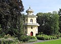
Duiventoren:
|
This is a category about rijksmonument number 512225
|
Tuinmuur:
|
This is a category about rijksmonument number 512226
|
Brug:
|
This is a category about rijksmonument number 512227
|
| Address |
|
Subcategories
This category has only the following subcategory.
2
Media in category "Huis Landfort, Megchelen"
The following 82 files are in this category, out of 82 total.
-
 2010-09-11 om oij landfort 01.JPG 2,816 × 2,112; 2.17 MB
-
 2010-09-11 om oij landfort 02.JPG 2,816 × 2,112; 1.92 MB
-
 2010-09-11 om oij landfort 03.JPG 2,599 × 1,878; 1.52 MB
-
 2010-09-11 om oij landfort 04.JPG 2,816 × 2,034; 1.35 MB
-
 2010-09-11 om oij landfort 05.JPG 2,816 × 2,112; 1.86 MB
-
 2010-09-11 om oij landfort 06.JPG 2,816 × 2,112; 1.34 MB
-
 2010-09-11 om oij landfort 07.JPG 2,499 × 1,803; 1.31 MB
-
 2010-09-11 om oij landfort 08.JPG 2,816 × 2,112; 1.16 MB
-
 2010-09-11 om oij landfort 09.JPG 1,437 × 1,995; 995 KB
-
 2010-09-11 om oij landfort 10.JPG 2,816 × 2,112; 967 KB
-
 2010-09-11 om oij landfort 11.JPG 2,816 × 2,112; 2.15 MB
-
 2010-09-11 om oij landfort 12.JPG 2,816 × 2,112; 1.26 MB
-
 2010-09-11 om oij landfort 13.JPG 2,440 × 1,765; 780 KB
-
 2010-09-11 om oij landfort 14.JPG 2,816 × 2,112; 997 KB
-
 2010-09-11 om oij landfort 15.JPG 2,816 × 2,112; 2.13 MB
-
 2010-09-11 om oij landfort 16.JPG 2,650 × 1,921; 1.07 MB
-
 2010-09-11 om oij landfort 17.JPG 2,486 × 1,798; 873 KB
-
 2010-09-11 om oij landfort 18.JPG 1,851 × 1,339; 873 KB
-
 2010-09-11 om oij landfort 19.JPG 2,469 × 1,786; 1.63 MB
-
 2010-09-11 om oij landfort 20.JPG 2,582 × 1,869; 1.58 MB
-
 2010-09-11 om oij landfort 21.JPG 2,515 × 1,815; 1.23 MB
-
 2010-09-11 om oij landfort 22.JPG 2,599 × 1,882; 1.5 MB
-
 2010-09-11 om oij landfort 23.JPG 2,816 × 2,112; 1.51 MB
-
 2010-09-11 om oij landfort 24.JPG 2,816 × 2,112; 1.46 MB
-
 2010-09-11 om oij landfort 25.JPG 2,595 × 1,878; 1.16 MB
-
 2010-09-11 om oij landfort 26.JPG 1,878 × 2,599; 981 KB
-
 2010-09-11 om oij landfort 27.JPG 2,816 × 2,112; 1.38 MB
-
 2010-09-11 om oij landfort 28.JPG 2,743 × 1,983; 1.4 MB
-
 2010-09-11 om oij landfort 29.JPG 2,816 × 2,112; 1.49 MB
-
 2010-09-11 om oij landfort 30.JPG 2,112 × 2,816; 1.64 MB
-
 2010-09-11 om oij landfort 31.JPG 2,112 × 2,816; 1.58 MB
-
 2010-09-11 om oij landfort 32.JPG 2,816 × 2,112; 2.46 MB
-
 2010-09-11 om oij landfort 33.JPG 2,674 × 1,928; 1.33 MB
-
 2010-09-11 om oij landfort 34.JPG 2,816 × 2,112; 2.12 MB
-
 2010-09-11 om oij landfort 35.JPG 2,816 × 2,112; 2.54 MB
-
 2010-09-11 om oij landfort 36.JPG 2,816 × 2,112; 2.86 MB
-
 2010-09-11 om oij landfort 37.JPG 2,816 × 2,112; 2 MB
-
 2022-05-09 Huis Landfort ZvD 01.jpg 6,000 × 3,376; 8.82 MB
-
 2022-05-09 Huis Landfort ZvD 02.jpg 6,000 × 3,376; 7.37 MB
-
 2022-05-09 Huis Landfort ZvD 03.jpg 6,000 × 3,376; 9.61 MB
-
 2022-05-09 Huis Landfort ZvD 04.jpg 6,000 × 3,376; 9.07 MB
-
 2022-05-09 Huis Landfort ZvD 05.jpg 6,000 × 3,376; 8.77 MB
-
 2022-05-09 Huis Landfort ZvD 06.jpg 6,000 × 3,376; 8.65 MB
-
 2022-05-09 Huis Landfort ZvD 07.jpg 6,000 × 3,376; 9.41 MB
-
 2022-05-09 Huis Landfort ZvD 08.jpg 6,000 × 3,376; 8.25 MB
-
 2022-05-09 Huis Landfort ZvD 09.jpg 6,000 × 3,376; 5.96 MB
-
 2022-05-09 Huis Landfort ZvD 10.jpg 6,000 × 3,376; 8 MB
-
 Exterieur DUIVENTOREN, VOORGEVEL, RECHTER ZIJGEVEL - Gendringen - 20339568 - RCE.jpg 1,171 × 1,200; 512 KB
-

-
 Exterieur OVERZICHT VOORZIJDE, LINKER ZIJGEVEL - Gendringen - 20339566 - RCE.jpg 1,188 × 1,200; 444 KB
-
 Exterieur VOORGEVEL (TIJDENS RESTAURATIE) - Gendringen - 20339567 - RCE.jpg 1,195 × 1,200; 414 KB
-
 Getty Research Institute (IA gri 33125010711923).pdf 979 × 1,500, 76 pages; 4.72 MB
-
 Huis Landfort Megchelen PM18-01.jpg 4,896 × 3,672; 6.54 MB
-
 Huis Landfort Megchelen PM18-02.jpg 4,896 × 3,672; 7.31 MB
-
 Huis Landfort, duiventil - Gendringen - 20077193 - RCE.jpg 1,200 × 1,200; 530 KB
-
 Huis Landfort, duiventil achtkantige toren - Gendringen - 20077192 - RCE.jpg 1,200 × 1,200; 484 KB
-

-

-

-
 Huis Landfort, interieur bovenkamer zijvleugel - Gendringen - 20077189 - RCE.jpg 1,200 × 945; 238 KB
-
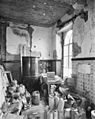
 Huis Landfort, interieur Grote salon - Gendringen - 20077186 - RCE.jpg 962 × 1,200; 269 KB
-
 Huis Landfort, interieur kelder - Gendringen - 20077182 - RCE.jpg 1,200 × 953; 214 KB
-
 Huis Landfort, interieur rechter voorkamer - Gendringen - 20077185 - RCE.jpg 954 × 1,200; 276 KB
-
 Huis Landfort, kleine salon links van de hal - Gendringen - 20077183 - RCE.jpg 1,200 × 938; 281 KB
-
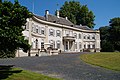
 Huis Landfort, overzicht achtergevel - Gendringen - 20077181 - RCE.jpg 1,200 × 941; 257 KB
-

-
 Huis Landfort, reproductie van tekening - Gendringen - 20077191 - RCE.jpg 1,046 × 656; 125 KB
-
 Huis Landfort, schouw in kleine salon - Gendringen - 20077184 - RCE.jpg 950 × 1,200; 263 KB
-
 Huis landfort-1559059367.JPG 5,456 × 3,632; 9.28 MB
-
 Intenieur, aanzicht orgel, orgelnummer 951 - Megchelen - 20417234 - RCE.jpg 925 × 1,200; 114 KB
-
 Interieur, detail, marmeren wasbak - Megchelen - 20424341 - RCE.jpg 1,200 × 1,200; 168 KB
-
 Interieur, hal - Megchelen - 20424325 - RCE.jpg 1,200 × 1,200; 188 KB
-
 Interieur, hal - Megchelen - 20424345 - RCE.jpg 1,200 × 1,200; 211 KB
-
 Interieur, hal - Megchelen - 20424346 - RCE.jpg 1,200 × 1,200; 197 KB
-
 Interieur, overzicht kamer - Megchelen - 20424336 - RCE.jpg 1,200 × 1,200; 236 KB
-
 Interieur, overzicht kamer - Megchelen - 20424338 - RCE.jpg 1,200 × 1,200; 300 KB
-
 Interieur, overzicht van kamer - Megchelen - 20424347 - RCE.jpg 1,200 × 1,200; 413 KB
-
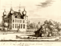 Landfort 1720.png 600 × 460; 273 KB
-
 Overzicht van de tuin - Megchelen - 20424344 - RCE.jpg 1,200 × 1,200; 244 KB
-
 Overzicht van de voorgevel met steigers - Megchelen - 20424343 - RCE.jpg 1,200 × 1,200; 407 KB
-
 Overzicht voorgevel - Megchelen - 20359557 - RCE.jpg 1,179 × 1,200; 404 KB
-
 Zicht op schijnvensters in de steigers - Megchelen - 20424342 - RCE.jpg 1,200 × 1,200; 287 KB


_-_Gendringen_-_20339565_-_RCE.jpg)

_-_Gendringen_-_20339567_-_RCE.jpg)


