Category:Huis Brakestein (Oosterhout)
Jump to navigation
Jump to search
| Object location | | View all coordinates using: OpenStreetMap |
|---|
castle in Oosterhout, Netherlands  | |||||
| Upload media | |||||
| Instance of | |||||
|---|---|---|---|---|---|
| Part of |
| ||||
| Location | Oosterhout, North Brabant, Netherlands | ||||
| Street address |
| ||||
| Located on street | |||||
| Heritage designation |
| ||||
 | |||||
Nederlands: Huis Brakestein
|
This is a category about rijksmonumentcomplex number 515765
|
Landhuis
|
This is a category about rijksmonument number 515764
|
Historische aanleg
|
This is a category about rijksmonument number 515766
|
Koetshuis
|
This is a category about rijksmonument number 515767
|
Pomp
|
This is a category about rijksmonument number 515768
|
Hekwerk
|
This is a category about rijksmonument number 515770
|
Muur
|
This is a category about rijksmonument number 515771
|
| Address |
|
Media in category "Huis Brakestein (Oosterhout)"
The following 19 files are in this category, out of 19 total.
-
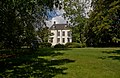 515764 Brakestein.jpg 2,951 × 1,930; 6.14 MB
-

-
 F1020021.JPG 1,840 × 1,232; 1.18 MB
-
 F1020022.JPG 1,840 × 1,232; 1.15 MB
-
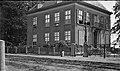 Glasplaatnegatieven van rond 1905-1910, Slotje Brakestein Oosterhout.jpg 5,430 × 3,196; 5.78 MB
-
 Ingangpartij koetshuis - Oosterhout - 20342560 - RCE.jpg 1,186 × 1,200; 415 KB
-

-
 Overzicht achterzijde koetshuis richting straatkant - Oosterhout - 20342564 - RCE.jpg 1,183 × 1,200; 429 KB
-
 Overzicht Huis Brakestein (achtergrond) met koetshuis - Oosterhout - 20342554 - RCE.jpg 1,183 × 1,200; 312 KB
-
 Overzicht Huis Brakestein met koetshuis - Oosterhout - 20342553 - RCE.jpg 1,200 × 962; 291 KB
-
 Parkeerplaatsen aan de achterzijde van Huis Brakestein - Oosterhout - 20342561 - RCE.jpg 1,180 × 1,200; 420 KB
-
 Parkeerplaatsen en ingangpartij koetshuis - Oosterhout - 20342559 - RCE.jpg 1,186 × 1,200; 418 KB
-
 Parkeerplaatsen voor het koetshuis van Huis Brakestein - Oosterhout - 20342557 - RCE.jpg 1,188 × 1,200; 433 KB
-
 Slotje Brakestein in 1730.jpg 1,247 × 915; 339 KB
-
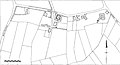 Slotjes van Oosterhout kaart omstreeks 1830.jpg 1,596 × 860; 192 KB
-

-
 Vanaf Kastanjedreef richting Ridderstraat - Oosterhout - 20174671 - RCE.jpg 1,183 × 1,200; 386 KB
-
 Voor- en zijgevel - Oosterhout - 20174950 - RCE.jpg 1,200 × 813; 284 KB
-
 Voorgevel met ingangpartij Huis Brakestein - Oosterhout - 20342555 - RCE.jpg 950 × 1,200; 278 KB


_met_koetshuis_-_Oosterhout_-_20342554_-_RCE.jpg)


