Category:Huer's Hut, Portreath
Jump to navigation
Jump to search
Daymark in Cornwall, England, UK .jpg) .jpg) | |||||
| Upload media | |||||
| Instance of | |||||
|---|---|---|---|---|---|
| Location | Portreath, Cornwall, South West England, England | ||||
| Heritage designation |
| ||||
 | |||||
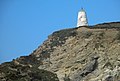
The pepperpot daymark on Lighthouse Hill Portreath Cornwall. Once used as a shelter from which a Huer would spot shoals of Pilchards in the bay (Huer’s Hut). It's not a lighthouse as such.
Not to be confused with this Huer's Hut, Portreath, (the Portreath Pepperpot)
Media in category "Huer's Hut, Portreath"
The following 10 files are in this category, out of 10 total.
-
 Daymark, Portreath - geograph.org.uk - 2807658.jpg 2,592 × 1,944; 1.1 MB
-
 Landmark above Portreath Harbour - geograph.org.uk - 809122.jpg 480 × 640; 100 KB
-
 Landmark north of Portreath (6416).jpg 4,288 × 2,848; 4.54 MB
-
 Modern Housing and Harbour Mouth - geograph.org.uk - 188876.jpg 640 × 411; 97 KB
-

-
 Portreath harbour day marker (geograph 3704446).jpg 1,024 × 689; 131 KB
-
 Portreath Harbour Wall, Cornwall - geograph.org.uk - 51149.jpg 640 × 480; 88 KB
-
 Portreath Sunset (26007816802).jpg 5,184 × 3,412; 8.18 MB
-
 Portreath Sunset HDR (20814755822).jpg 3,777 × 2,440; 3.08 MB
-
 Portreath, Cornwall.jpg 1,920 × 1,365; 204 KB


.jpg)


.jpg)
