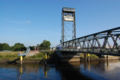
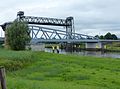
Category:Hubbrücke Huntebrück
Jump to navigation
Jump to search
| Object location | | View all coordinates using: OpenStreetMap |
|---|
former bridge near Berne, Germany  | |||||
| Upload media | |||||
| Instance of | |||||
|---|---|---|---|---|---|
| Location | |||||
| Crosses | |||||
| Carries | |||||
| Heritage designation | |||||
| Inception |
| ||||
| Date of official closure |
| ||||
| Dissolved, abolished or demolished date |
| ||||
 | |||||
Media in category "Hubbrücke Huntebrück"
The following 11 files are in this category, out of 11 total.
-
 Alte & neue Huntebrücke von Norden579.JPG 4,000 × 3,000; 4.58 MB
-
 HubbrueckeHuntebrueck.jpg 2,365 × 1,676; 607 KB
-
 Hunte Hubbr 20140914 1.jpg 1,920 × 1,279; 921 KB
-
 Huntebruecke 7000.jpg 3,262 × 2,258; 1.7 MB
-
 Huntebruecke.png 912 × 609; 942 KB
-
 Huntebruecken 6389.jpg 2,565 × 1,776; 652 KB
-
 Imagedrohne.com Huntebrücke - panoramio.jpg 1,140 × 775; 631 KB
-
 Lower Saxony - Hubbrücke Huntebrück - 20180824205851.jpg 3,898 × 2,598; 5.47 MB
-
 Neue & alte Huntebrücke v Mündung Untere Ollen597.JPG 4,000 × 3,000; 4.71 MB
-
 Neue & alte Huntebrücke v rechten Huntedeich585.JPG 3,929 × 2,908; 7.56 MB
-
 Schöpfwerk Lichtenberg v O588.JPG 4,000 × 3,000; 4.6 MB


