Category:Hovs kyrka, Skåne
Jump to navigation
Jump to search
| Object location | | View all coordinates using: OpenStreetMap |
|---|
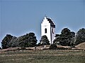
church building in Båstad Municipality, Skåne County, Sweden  | |||||
| Upload media | |||||
| Instance of | |||||
|---|---|---|---|---|---|
| Location | Hov, Båstad Municipality, Skåne County, Sweden | ||||
| Diocese | |||||
| Connects with |
| ||||
| Architect | |||||
| Has use |
| ||||
| Occupant | |||||
| Heritage designation |
| ||||
| Inception |
| ||||
| Different from | |||||
 | |||||
Svenska: Hovs kyrka tillhör Västra Karup-Hovs församling, Bjäre kontrakt, Lunds stift / Diocese of Lund.
|
This is a category about an ecclesiastical monument in Sweden, number 21300000006485 (sub-number: 21400000548704) in the RAÄ buildings database.
|
Subcategories
This category has only the following subcategory.
I
Media in category "Hovs kyrka, Skåne"
The following 18 files are in this category, out of 18 total.
-
 Hovs kyrka - KMB - 16000200054341.jpg 800 × 535; 24 KB
-
 Hovs kyrka - KMB - 16000200054342.jpg 800 × 518; 31 KB
-
 Hovs kyrka - KMB - 16000200054348.jpg 800 × 536; 24 KB
-
 Hovs kyrka - KMB - 16000200054349.jpg 393 × 600; 18 KB
-
 Hovs kyrka - KMB - 16000200054353.jpg 800 × 555; 28 KB
-
 Hovs kyrka - KMB - 16000200054358.jpg 416 × 600; 14 KB
-
 Hovs kyrka - KMB - 16000200054366.jpg 393 × 600; 19 KB
-
 Hovs kyrka - KMB - 16000200054367.jpg 394 × 600; 16 KB
-
 Hovs kyrka - KMB - 16001000022193.jpg 570 × 576; 189 KB
-
 Hovs kyrka ext1.jpg 4,000 × 3,000; 2.96 MB
-
 Hovs kyrka ext2.jpg 4,000 × 3,000; 2.61 MB
-
 Hovs kyrka ext3.jpg 2,983 × 2,329; 1.43 MB
-
 Hovs kyrka ext4.jpg 2,975 × 2,217; 1.29 MB
-
 Hovs kyrka ext5.jpg 2,967 × 2,962; 2.07 MB
-
 Hovs kyrka.jpg 4,752 × 3,168; 5.26 MB
-
 Hovs kyrkogård1.jpg 4,000 × 3,000; 2.97 MB
-
 Hovs kyrkogård2.jpg 4,000 × 3,000; 2.84 MB
-
 Kirche unterwegs.jpg 3,648 × 2,736; 2.92 MB


Categories:
- Built in Båstad Municipality in 1839
- Churches in Båstad Municipality
- Churches in the Diocese of Lund
- Churches in Skåne County built in 1839
- Stone churches in Skåne County
- Listed churches in Båstad Municipality
- Samuel Enander
- White churches in Sweden
- Neoclassical churches in Skåne County
- Hov District, Båstad Municipality