Category:Hornos de cal de El Cotillo
Jump to navigation
Jump to search
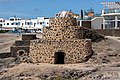
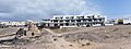
English: Five different lime kilns close together, counted from top to bottom:
1
| Object location | | View all coordinates using: OpenStreetMap |
|---|
2
| Object location | | View all coordinates using: OpenStreetMap |
|---|
3
| Object location | | View all coordinates using: OpenStreetMap |
|---|
4
| Object location | | View all coordinates using: OpenStreetMap |
|---|
5
| Object location | | View all coordinates using: OpenStreetMap |
|---|
  | |||||
| Upload media | |||||
| Instance of | |||||
|---|---|---|---|---|---|
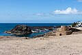
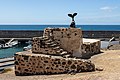
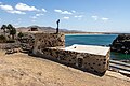
| Location | El Cotillo, La Oliva, Las Palmas, Canary Islands, Spain | ||||
 | |||||
Media in category "Hornos de cal de El Cotillo"
The following 39 files are in this category, out of 39 total.
-
 35650 El Cotillo, Las Palmas, Spain - panoramio (32).jpg 5,184 × 2,920; 5.53 MB
-
 At El Cotillo 2022 011.jpg 6,960 × 4,640; 12.34 MB
-
 At El Cotillo 2022 012.jpg 6,960 × 4,640; 10.47 MB
-
 At El Cotillo 2022 028.jpg 6,792 × 4,592; 10.63 MB
-
 At El Cotillo 2022 030.jpg 6,960 × 4,640; 14.74 MB
-
 At El Cotillo 2022 034.jpg 6,911 × 4,607; 12.39 MB
-
 At El Cotillo 2022 035.jpg 6,960 × 4,640; 10.53 MB
-
 At El Cotillo 2022 036.jpg 6,960 × 4,640; 25.72 MB
-
 At El Cotillo 2022 037.jpg 6,960 × 4,640; 12.37 MB
-
 At El Cotillo 2022 038.jpg 6,960 × 4,640; 11.29 MB
-
 At El Cotillo 2022 039.jpg 4,640 × 6,960; 10.25 MB
-
 At El Cotillo 2022 040.jpg 4,640 × 6,960; 11.08 MB
-
 At El Cotillo 2022 041.jpg 6,960 × 4,640; 10.59 MB
-
 At El Cotillo 2022 042.jpg 6,960 × 4,640; 11.61 MB
-
 At El Cotillo 2022 043.jpg 6,960 × 4,640; 12.95 MB
-
 At El Cotillo 2022 044.jpg 6,960 × 4,640; 10.58 MB
-
 At El Cotillo 2022 045.jpg 6,960 × 4,640; 12.95 MB
-
 At El Cotillo 2022 048.jpg 6,843 × 4,562; 16.96 MB
-
 At El Cotillo 2022 049.jpg 6,960 × 4,640; 10.93 MB
-
 At El Cotillo 2022 061.jpg 6,960 × 4,640; 10.14 MB
-
 At El Cotillo 2022 062.jpg 6,960 × 4,640; 10.18 MB
-
 At El Cotillo 2022 063.jpg 6,960 × 4,640; 17.29 MB
-
 At El Cotillo 2022 065.jpg 4,640 × 6,960; 12.83 MB
-
 Fuerteventura - El Cotillo - Horno de cal.jpg 7,290 × 2,712; 10.34 MB
-
 Fuerteventura - El Cotillo - Port 01.jpg 7,335 × 3,983; 16.56 MB
-
 La Oliva El Cotillo - 5xhorno (Castillo) 01 ies.jpg 5,616 × 3,744; 8.43 MB
-
 La Oliva El Cotillo - Calle 3 de Abril de 1979 - horno 5 01 ies.jpg 5,616 × 3,744; 8.29 MB
-
 La Oliva El Cotillo - Calle 3 de Abril de 1979 - horno 5 02 ies.jpg 5,616 × 3,744; 7.45 MB
-
 La Oliva El Cotillo - Calle de la Caleta - horno 3 01 ies.jpg 5,616 × 3,744; 6.98 MB
-
 La Oliva El Cotillo - Calle de la Caleta - horno 3+4+castillo 01 ies.jpg 5,616 × 3,744; 7.15 MB
-
 La Oliva El Cotillo - Calle de la Caleta - horno 3+castillo 01 ies.jpg 5,616 × 3,744; 7.56 MB
-
 La Oliva El Cotillo - Calle de la Caleta - horno 4 01 ies.jpg 5,616 × 3,744; 7.09 MB
-
 La Oliva El Cotillo - Calle Pinito de Oro - horno 1 01 ies.jpg 5,616 × 3,744; 8.42 MB
-
 La Oliva El Cotillo - Calle Pinito de Oro - horno 1+2 (Castillo) 01 ies.jpg 5,616 × 3,744; 9.16 MB
-
 La Oliva El Cotillo - Calle Pinito de Oro - horno 1+2 (Castillo) 02 ies.jpg 5,616 × 3,744; 9.32 MB
-
 La Oliva El Cotillo - Calle Pinito de Oro - horno 1+castillo 01 ies.jpg 5,616 × 3,744; 7.48 MB
-
 La Oliva El Cotillo - Calle Pinito de Oro - horno 1+castillo 02 ies.jpg 5,616 × 3,744; 7.84 MB
-
 La Oliva El Cotillo - Calle Pinito de Oro - horno 2 01 ies.jpg 5,616 × 3,744; 8.56 MB
-
 WLM14ES - Torre del Tostón - rvr (1).jpg 5,184 × 3,456; 5.41 MB
.jpg)


_01_ies.jpg)


_01_ies.jpg)
_02_ies.jpg)


.jpg)