Category:Horla kyrka
Jump to navigation
Jump to search
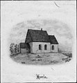
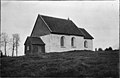
Svenska: Horla kyrka tillhör Hols församling, Kullings kontrakt, Skara stift / Diocese of Skara.
| Object location | | View all coordinates using: OpenStreetMap |
|---|
|
This is a category about an ecclesiastical monument in Sweden, number 21300000003339 in the RAÄ buildings database.
|
|
This is a category about a protected building in Sweden, number 21400000443691 in the RAÄ buildings database.
|
church building in Vårgårda Municipality, Västra Götaland County, Sweden  | |||||
| Upload media | |||||
| Instance of | |||||
|---|---|---|---|---|---|
| Location | Vårgårda Municipality, Västra Götaland County, Sweden | ||||
| Diocese | |||||
| Has use |
| ||||
| Occupant | |||||
| Heritage designation |
| ||||
 | |||||
Media in category "Horla kyrka"
The following 34 files are in this category, out of 34 total.
-
 Horla kyrka - KMB - 16000200158068.jpg 556 × 600; 73 KB
-
 Horla kyrka - KMB - 16000200158069.jpg 847 × 600; 154 KB
-
 Horla kyrka - KMB - 16000200158070.jpg 750 × 600; 106 KB
-
 Horla kyrka - KMB - 16000200158072.jpg 838 × 600; 79 KB
-
 Horla kyrka - KMB - 16000200158078.jpg 731 × 600; 75 KB
-
 Horla kyrka - KMB - 16000200158080.jpg 435 × 600; 43 KB
-
 Horla kyrka - KMB - 16000200158085.jpg 816 × 600; 61 KB
-
 Horla kyrka - KMB - 16000200158088.jpg 389 × 600; 48 KB
-
 Horla kyrka - KMB - 16000200158089.jpg 747 × 600; 52 KB
-
 Horla kyrka - KMB - 16000200158090.jpg 925 × 600; 83 KB
-
 Horla kyrka - KMB - 16000200158091.jpg 430 × 600; 53 KB
-
 Horla kyrka - KMB - 16000200158092.jpg 389 × 600; 39 KB
-
 Horla kyrka - KMB - 16000200158093.jpg 386 × 600; 32 KB
-
 Horla kyrka - KMB - 16000200158095.jpg 387 × 600; 48 KB
-
 Horla kyrka - KMB - 16000200158097.jpg 927 × 600; 84 KB
-
 Horla kyrka - KMB - 16000200158099.jpg 400 × 600; 35 KB
-
 Horla kyrka - KMB - 16000200158100.jpg 390 × 600; 30 KB
-
 Horla kyrka - KMB - 16000200158101.jpg 397 × 600; 36 KB
-
 Horla kyrka - KMB - 16000200158102.jpg 932 × 600; 75 KB
-
 Horla kyrka - KMB - 16000200158103.jpg 943 × 600; 71 KB
-
 Horla kyrka - KMB - 16000200158104.jpg 929 × 600; 60 KB
-
 Horla kyrka - KMB - 16000200158105.jpg 404 × 600; 33 KB
-
 Horla kyrka - KMB - 16000200158106.jpg 935 × 600; 56 KB
-
 Horla kyrka - KMB - 16000200158107.jpg 956 × 600; 59 KB
-
 Horla kyrka - KMB - 16000200158108.jpg 922 × 600; 80 KB
-
 Horla kyrka - KMB - 16000200158109.jpg 826 × 600; 70 KB
-
 Horla kyrka - KMB - 16000200158110.jpg 380 × 600; 43 KB
-
 Horla kyrka - KMB - 16000200158111.jpg 380 × 600; 49 KB
-
 Horla kyrka - KMB - 16000200158112.jpg 414 × 600; 44 KB
-
 Horla kyrka - KMB - 16000200158113.jpg 842 × 600; 141 KB
-
 Horla kyrka 1.JPG 3,139 × 1,957; 3.86 MB
-
 Horla kyrka 2.JPG 3,267 × 2,178; 4.81 MB
-
 Horla kyrka old1.jpg 918 × 600; 87 KB
-
 Horla kyrka old2.jpg 836 × 600; 70 KB


