<nowiki>Horath; Horath; Horath; Horath; Horath; Horath; Horath; 霍拉特; Horath; Horath; Горат; 霍拉特; Horath; Horath; Horath; Хорат; Horath; Horath; Horath; Horath; Horath; Horath; Horath; حورات; Xorat; Horath; Хорат; Horath; Horath; Horath; Хорат; Horath; Horath; Horath; Horath; Horath; Хорат; Horath; Horath; 霍拉特; Horath; Хорат; Horath; Horath; Хорат; Horath; هورات; 霍拉特; Horath; Horat; ホラート; Horath; Horath; Horath; Horath; Horath; Хорат; Horath; Horath (munisipyo); Horath; Horath; Horath; Horath; Horath; Horath; Horath; Horath; Horath; Horath; Horath; Horath; Horath; Horath; Horath; Horath; Horath; Horath; Horath; Horath; Horath; Horath; Horath; Horath; Horath; Horath; Horath; Horath; Horath; Horath; Horath; Хорат; Horath; Horath; Horath; Horath; Horath; Horath; Municipio de Bernkastel-Wittlich, estado de Renania-Palatinado, Alemania; commune allemande; kommune i Tyskland; obec v zemském okresu Bernkastel-Wittlich v Německu; громада в Німеччині, федеральна земля Рейнланд-Пфальц; gemeente in Rijnland-Palts; komunumo en Rejnlando-Palatinato, Germanio; municipality of Germany; Gemeinde in Deutschland; település Németországban; komunë në Gjermani; بلدية في ألمانيا; kumun alaman; Şaredariyeke Almanyayê; Ҳоратҳ; Xorat; Хорат; Horath</nowiki>
Subcategories
This category has only the following subcategory.


 Banner Horath.gif 216 × 432; 3 KB
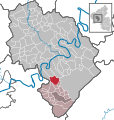 Horath in WIL.svg 634 × 666; 402 KB