Category:Hoornderweg 21, Den Burg
Jump to navigation
Jump to search
| Object location | | View all coordinates using: OpenStreetMap |
|---|
|
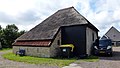
This is a category about a municipal monument in Texel with number 50 |
Nederlands: Stolpboerderij De Hoge Kamp - anno 1899
Media in category "Hoornderweg 21, Den Burg"
The following 2 files are in this category, out of 2 total.
-
 Hoornderweg 21, Den Burg (Texel) 01.jpg 4,287 × 2,373; 4.78 MB
-
 Hoornderweg 21, Den Burg (Texel) 02.jpg 4,320 × 2,432; 4.8 MB
_01.jpg)
_02.jpg)