Category:Hoofdweg 66, Bellingwolde
Jump to navigation
Jump to search
| Object location | | View all coordinates using: OpenStreetMap |
|---|
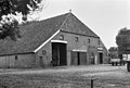
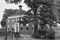
farmhouse in Bellingwedde, Netherlands  | |||||
| Upload media | |||||
| Instance of | |||||
|---|---|---|---|---|---|
| Location | Bellingwolde, Groningen, Netherlands | ||||
| Located on street | |||||
| Heritage designation |
| ||||
 | |||||
|
This is a category about rijksmonument number 8893
|
| Address |
|
Media in category "Hoofdweg 66, Bellingwolde"
The following 9 files are in this category, out of 9 total.
-
 Achtergevel - Bellingwolde - 20030205 - RCE.jpg 1,200 × 955; 327 KB
-
 Achterzijde - Bellingwolde - 20030196 - RCE.jpg 1,200 × 809; 280 KB
-
 Bellingwolde Hoofdweg 66.jpg 4,000 × 3,000; 1.35 MB
-
 Linker zijgevel - Bellingwolde - 20030204 - RCE.jpg 1,200 × 959; 362 KB
-
 Overzicht - Bellingwolde - 20030201 - RCE.jpg 1,200 × 949; 344 KB
-
 Voor- en rechter zijgevel - Bellingwolde - 20030202 - RCE.jpg 1,200 × 952; 377 KB
-
 Voorgevel - Bellingwolde - 20030203 - RCE.jpg 1,200 × 961; 329 KB
-
 Voorgevel nr. 114883 - Bellingwolde - 20475308 - RCE.jpg 1,200 × 900; 194 KB
-
 Voorzijde - Bellingwolde - 20030195 - RCE.jpg 1,200 × 811; 296 KB


