Category:Hoofdweg 29, Godlinze
Jump to navigation
Jump to search
| Object location | | View all coordinates using: OpenStreetMap |
|---|
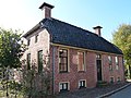
building in Delfzijl, Netherlands  | |||||
| Upload media | |||||
| Instance of | |||||
|---|---|---|---|---|---|
| Location | Godlinze, Eemsdelta, Groningen, Netherlands | ||||
| Street address |
| ||||
| Located on street |
| ||||
| Heritage designation |
| ||||
 | |||||
|
This is a category about rijksmonument number 9468
|
| Address |
|
Media in category "Hoofdweg 29, Godlinze"
The following 15 files are in this category, out of 15 total.
-
 Achtergevel - Godlinze - 20078852 - RCE.jpg 1,200 × 1,200; 400 KB
-
 Achterzijde - Godlinze - 20078849 - RCE.jpg 1,197 × 1,200; 351 KB
-
 Exterieur ACHTERGEVEL - Godlinze - 20296274 - RCE.jpg 1,200 × 1,185; 372 KB
-
 Exterieur LINKER ZIJGEVEL - Godlinze - 20296272 - RCE.jpg 1,200 × 1,197; 319 KB
-
 Exterieur OVERZICHT ACHTERGEVEL - Godlinze - 20296273 - RCE.jpg 1,200 × 1,197; 375 KB
-
 Exterieur RECHTER ZIJGEVEL - Godlinze - 20296270 - RCE.jpg 1,195 × 1,200; 301 KB
-
 Exterieur VOORGEVEL - Godlinze - 20296269 - RCE.jpg 1,200 × 1,192; 309 KB
-
 Exterieur VOORGEVEL, LINKER ZIJGEVEL - Godlinze - 20296271 - RCE.jpg 1,200 × 1,183; 265 KB
-
 Godlinze - Hoofdweg 29.jpg 3,666 × 2,750; 3.2 MB
-
 INTERIEUR, KAMER - Godlinze - 20296277 - RCE.jpg 1,200 × 1,188; 265 KB
-
 INTERIEUR, OVERZICHT - Godlinze - 20296275 - RCE.jpg 1,200 × 1,200; 274 KB
-
 INTERIEUR, OVERZICHT - Godlinze - 20296276 - RCE.jpg 1,191 × 1,200; 253 KB
-
 Linker zijgevel - Godlinze - 20078851 - RCE.jpg 1,193 × 1,200; 291 KB
-
 Voor- en rechter zijgevel - Godlinze - 20078850 - RCE.jpg 1,195 × 1,200; 296 KB
-
 Voorzijde - Godlinze - 20078848 - RCE.jpg 1,200 × 1,195; 351 KB


