Category:Honthorststraat 25, Amsterdam
Jump to navigation
Jump to search
| Object location | | View all coordinates using: OpenStreetMap |
|---|
 | |||||
| Upload media | |||||
| Instance of | |||||
|---|---|---|---|---|---|
| Location | Amsterdam Oud-Zuid, Amsterdam-Zuid, Amsterdam, North Holland, Netherlands | ||||
| Street address |
| ||||
| Located on street |
| ||||
| Heritage designation |
| ||||
 | |||||
|
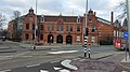
This is a category about rijksmonument number 1994
|
| Address |
|
Media in category "Honthorststraat 25, Amsterdam"
The following 9 files are in this category, out of 9 total.
-
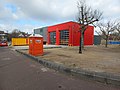 2022 Noodgebouw Brandweer Dirk, Asd.jpg 4,624 × 3,468; 4.14 MB
-
 Amsterdam 0017.jpg 4,288 × 3,216; 2.91 MB
-
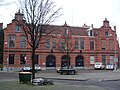 Brandweerkazerne Honthorststraat 25.jpg 3,072 × 2,304; 1.77 MB
-
 Honthorststraat 25-27 (1).jpg 5,312 × 2,988; 5.51 MB
-
 Honthorststraat 25-27 (2).jpg 5,312 × 2,988; 5.36 MB
-
 Linker zijgevel - Amsterdam - 20017578 - RCE.jpg 1,200 × 961; 246 KB
-
 Overzicht brandweerkazerne - Amsterdam - 20017576 - RCE.jpg 1,200 × 1,200; 253 KB
-

-
 Voorgevel - Amsterdam - 20017577 - RCE.jpg 1,193 × 1,200; 262 KB


.jpg)
.jpg)


