Category:Honingham
Jump to navigation
Jump to search
English: Honingham is a village and civil parish in the English county of Norfolk, located and had a population of 342 in 145 households as of the 2001 census.
village in the United Kingdom  | |||||
| Upload media | |||||
| Instance of | |||||
|---|---|---|---|---|---|
| Location | Broadland, Norfolk, East of England, England | ||||
| Population |
| ||||
| Area |
| ||||
| Said to be the same as | Honingham (Wikimedia duplicated page, civil parish) | ||||
 | |||||
Subcategories
This category has the following 3 subcategories, out of 3 total.
A
- St Andrew's, Honingham (7 F)
Media in category "Honingham"
The following 200 files are in this category, out of 212 total.
(previous page) (next page)-
 A Pot Of Gold - geograph.org.uk - 295765.jpg 637 × 484; 104 KB
-

-
 A47 - B1147 junction - geograph.org.uk - 4370968.jpg 640 × 426; 36 KB
-
 A47 - geograph.org.uk - 4361968.jpg 640 × 426; 58 KB
-
 A47 - geograph.org.uk - 4370971.jpg 640 × 426; 42 KB
-

-
 A47 at Honingham - geograph.org.uk - 5091268.jpg 1,952 × 1,928; 1.79 MB
-
 A47 at Honingham - geograph.org.uk - 5171236.jpg 1,694 × 1,626; 1.7 MB
-
 A47 at Honingham - geograph.org.uk - 5174089.jpg 2,176 × 1,271; 2.35 MB
-
 A47 at Honingham - geograph.org.uk - 5174095.jpg 2,260 × 1,344; 3.45 MB
-
 A47 West of Honingham - geograph.org.uk - 4726398.jpg 640 × 427; 365 KB
-
 A47 Westbound near to Honingham - geograph.org.uk - 4726389.jpg 640 × 427; 428 KB
-
 A47, east - geograph.org.uk - 4370973.jpg 640 × 426; 52 KB
-
 A47, eastbound - geograph.org.uk - 4370980.jpg 640 × 426; 43 KB
-
 A47, eastbound - geograph.org.uk - 4370993.jpg 640 × 426; 47 KB
-
 A47, eastbound - geograph.org.uk - 4370996.jpg 640 × 426; 54 KB
-
 A47, eastbound - geograph.org.uk - 4371003.jpg 640 × 426; 38 KB
-
 A47, Honingham bypass - geograph.org.uk - 4370976.jpg 640 × 426; 55 KB
-
 A47, Honingham bypass - geograph.org.uk - 4370986.jpg 640 × 426; 59 KB
-
 A47, westbound - geograph.org.uk - 4361971.jpg 640 × 426; 44 KB
-
 A47, Westbound - geograph.org.uk - 4362050.jpg 640 × 426; 45 KB
-
 Advert in a layby, by the A47 - geograph.org.uk - 4371356.jpg 640 × 426; 33 KB
-
 Air vent of WW2 air raid shelter - geograph.org.uk - 4031058.jpg 640 × 480; 273 KB
-
 Approaching Paddy's Lane on The Broadway - geograph.org.uk - 4025337.jpg 640 × 480; 271 KB
-
 B1535 Wood Lane, Frans Green - geograph.org.uk - 5092623.jpg 2,260 × 1,727; 2.39 MB
-
 B1535 Wood Lane, Honingham - geograph.org.uk - 5091254.jpg 3,072 × 2,304; 2.05 MB
-
 B1535 Wood Lane, Honingham - geograph.org.uk - 5171243.jpg 1,925 × 1,817; 2.94 MB
-

-
 Blind Lane - geograph.org.uk - 3418933.jpg 3,072 × 2,304; 1.33 MB
-
 Blind Lane and Red Barn, Honingham - geograph.org.uk - 3418948.jpg 3,072 × 2,304; 1.25 MB
-
 Blind Lane meets A47 - geograph.org.uk - 5557617.jpg 1,600 × 1,200; 234 KB
-
 Blind Lane to A47 - geograph.org.uk - 5557603.jpg 1,600 × 1,200; 418 KB
-
 Blind Lane to A47 - geograph.org.uk - 5557606.jpg 1,600 × 1,200; 419 KB
-
 Blind Lane to the A47 - geograph.org.uk - 5557613.jpg 1,600 × 1,162; 285 KB
-
 Bracken and pheasant feeder - geograph.org.uk - 5538980.jpg 640 × 480; 390 KB
-

-
 Bracken fronds turning brown - geograph.org.uk - 5538985.jpg 640 × 480; 404 KB
-
 Brickkiln Clump - geograph.org.uk - 5539019.jpg 640 × 590; 447 KB
-

-
 Cart shed at Greenacres Farm, Honingham - geograph.org.uk - 4279563.jpg 640 × 480; 122 KB
-

-
 Change Of Use - geograph.org.uk - 296113.jpg 640 × 480; 99 KB
-
-
 Colour blindness - geograph.org.uk - 2115494.jpg 1,280 × 960; 198 KB
-
 Common earthball (Scleroderma citrinum) - geograph.org.uk - 5538996.jpg 600 × 586; 202 KB
-

-
 Conifer wood - geograph.org.uk - 5539002.jpg 640 × 480; 384 KB
-
 Conifers and bracken - geograph.org.uk - 5538988.jpg 640 × 480; 414 KB
-
 Cottages in The Street, Honingham - geograph.org.uk - 2045707.jpg 640 × 480; 168 KB
-
 Cottages in The Street, Honingham - geograph.org.uk - 2045711.jpg 640 × 480; 203 KB
-
 Country Lane - geograph.org.uk - 1902214.jpg 640 × 480; 88 KB
-
 Crop fields beside Norwich Road - geograph.org.uk - 5325978.jpg 640 × 480; 378 KB
-
 Crop fields south of Ringland - geograph.org.uk - 5539010.jpg 640 × 576; 422 KB
-

-
 Crossroads, A47 - geograph.org.uk - 4361962.jpg 640 × 426; 68 KB
-
 Crossroads, Mattishall Rd - geograph.org.uk - 4362015.jpg 640 × 426; 56 KB
-
 Crossroads, Norwich Rd - geograph.org.uk - 4362032.jpg 640 × 426; 63 KB
-
 Entrance to an air raid shelter - geograph.org.uk - 4031037.jpg 640 × 480; 274 KB
-

-
 Field by Blind Lane - geograph.org.uk - 5557610.jpg 1,600 × 1,200; 398 KB
-
 Field west of Blind Lane - geograph.org.uk - 5326007.jpg 640 × 620; 507 KB
-
 Fields east of Blind Lane - geograph.org.uk - 5326009.jpg 640 × 480; 381 KB
-
 Flowering cherry trees near Honingham church - geograph.org.uk - 4460358.jpg 1,024 × 768; 500 KB
-
 Free range pigs near Weston Green - geograph.org.uk - 4031063.jpg 640 × 480; 164 KB
-
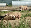 Free range pigs north of Breck Road - geograph.org.uk - 4031086.jpg 640 × 587; 226 KB
-
 Gate into a field by Red Barn - geograph.org.uk - 5325983.jpg 640 × 480; 374 KB
-
 Gate into fields north of Norwich Road - geograph.org.uk - 5325968.jpg 640 × 480; 373 KB
-
 Gated farm track - geograph.org.uk - 5539014.jpg 640 × 480; 273 KB
-
 Gated track north of The Broadway - geograph.org.uk - 4025331.jpg 640 × 480; 262 KB
-
 Give Way for the A47 - geograph.org.uk - 4282729.jpg 665 × 480; 90 KB
-
 Grange farm - geograph.org.uk - 2115379.jpg 1,280 × 960; 275 KB
-
 Greenacres Farm, Honingham - geograph.org.uk - 4279561.jpg 640 × 469; 131 KB
-
 Honingham Buck - geograph.org.uk - 2047878.jpg 640 × 480; 59 KB
-
 Honingham St Andrew's church - geograph.org.uk - 2264539.jpg 640 × 480; 167 KB
-
 Honingham Thorpe sign - geograph.org.uk - 3418967.jpg 2,304 × 3,072; 1.76 MB
-
 Honingham village pump and blacksmith's - geograph.org.uk - 4615758.jpg 3,456 × 2,592; 6.83 MB
-
 Honingham War Memorial - geograph.org.uk - 4400440.jpg 1,024 × 768; 410 KB
-
 Honingham Windmill - geograph.org.uk - 4362018.jpg 640 × 426; 50 KB
-
 In Memory of Curley - geograph.org.uk - 2047884.jpg 640 × 480; 70 KB
-
 Junction at Mattishall Road, Honingham - geograph.org.uk - 4279529.jpg 640 × 480; 113 KB
-

-
 Large puddles on private farm track - geograph.org.uk - 5539199.jpg 640 × 480; 253 KB
-
 Layby beside Wood Lane - geograph.org.uk - 5539205.jpg 640 × 480; 279 KB
-
 Layby on Eastbound A47 - geograph.org.uk - 4726540.jpg 640 × 480; 364 KB
-

-
 Mattishall Rd - geograph.org.uk - 4361984.jpg 640 × 426; 62 KB
-
 Mattishall Rd - geograph.org.uk - 4362007.jpg 640 × 426; 68 KB
-
 Mattishall Rd - geograph.org.uk - 4362010.jpg 640 × 426; 62 KB
-
 Mattishall Rd - geograph.org.uk - 4362022.jpg 640 × 426; 72 KB
-
 Mattishall Road, Honingham - geograph.org.uk - 3419058.jpg 3,072 × 2,304; 1.09 MB
-
 Milestone - geograph.org.uk - 1257272.jpg 480 × 640; 114 KB
-

-
 Muddy lane - geograph.org.uk - 2115462.jpg 1,280 × 960; 366 KB
-
 New double field gate - geograph.org.uk - 4279537.jpg 640 × 480; 107 KB
-
 New field gate at Greenacres Farm - geograph.org.uk - 4279559.jpg 640 × 480; 213 KB
-
 New road layout - geograph.org.uk - 4282733.jpg 640 × 422; 76 KB
-
 Norwich 8 Dereham 8 - geograph.org.uk - 1587281.jpg 640 × 480; 86 KB
-
 Norwich Rd - geograph.org.uk - 4362026.jpg 640 × 426; 60 KB
-
 Norwich Rd - geograph.org.uk - 4362029.jpg 640 × 426; 71 KB
-
 Norwich Rd, Mattishall Rd junction - geograph.org.uk - 4361998.jpg 640 × 426; 60 KB
-
 Norwich Road, Honingham - geograph.org.uk - 3419049.jpg 3,072 × 2,304; 1.63 MB
-

-
 Pheasant feeder in unnamed wood - geograph.org.uk - 5538977.jpg 640 × 480; 377 KB
-

-
 Pylon and maize strip - geograph.org.uk - 5557630.jpg 1,600 × 1,200; 429 KB
-
 Red Barn and Red Barn Cottage - geograph.org.uk - 5326001.jpg 640 × 480; 289 KB
-
 Red Barn Cottage - geograph.org.uk - 5325998.jpg 640 × 588; 453 KB
-
 Red Barn, Honingham - geograph.org.uk - 95577.jpg 640 × 426; 62 KB
-
 Remains of old RAF building - geograph.org.uk - 4031051.jpg 640 × 480; 284 KB
-
 Road from Honingham near Greenacres Farm - geograph.org.uk - 4279546.jpg 640 × 480; 136 KB
-
 Road into Honingham near Greenacres Farm - geograph.org.uk - 4279541.jpg 640 × 480; 153 KB
-
 Road junction by Red Barn - geograph.org.uk - 5325987.jpg 640 × 480; 263 KB
-
 Road junction by Red Barn - geograph.org.uk - 5557601.jpg 1,600 × 1,200; 354 KB
-
 Roundabout, A47 - geograph.org.uk - 4361980.jpg 640 × 426; 39 KB
-
 Safety Net - geograph.org.uk - 975426.jpg 480 × 640; 80 KB
-
 Small pond beside Norwich Road - geograph.org.uk - 5325973.jpg 640 × 480; 485 KB
-

-

-

-

-

-

-

-

-
 St Andrew's church in Honingham - geograph.org.uk - 2045751.jpg 640 × 480; 152 KB
-

-

-

-

-

-

-

-

-

-

-

-

-
 Stubble field - geograph.org.uk - 2115505.jpg 1,280 × 960; 146 KB
-
 Taverham Road - geograph.org.uk - 5557618.jpg 1,600 × 1,241; 377 KB
-
 Taverham Road - geograph.org.uk - 5557632.jpg 1,600 × 1,200; 518 KB
-
 Taverham Road - geograph.org.uk - 5610115.jpg 1,600 × 1,200; 392 KB
-
 The A47 - geograph.org.uk - 4371000.jpg 640 × 426; 30 KB
-
 The A47 - geograph.org.uk - 670111.jpg 640 × 480; 153 KB
-
 The Holiday Property Bond Building - geograph.org.uk - 278763.jpg 640 × 480; 100 KB
-

-
 To Weston Green on Breck Road - geograph.org.uk - 4031088.jpg 640 × 480; 204 KB
-
 Track into fields by Breck Barn - geograph.org.uk - 5539015.jpg 640 × 480; 306 KB
-
 Tree by Taverham Road - geograph.org.uk - 5557625.jpg 1,600 × 1,200; 388 KB
-
 Trees growing in a field boundary hedge - geograph.org.uk - 5326005.jpg 640 × 480; 373 KB
-

-
 USAAF camp site near Weston Green - geograph.org.uk - 4031033.jpg 640 × 480; 281 KB
-
 View along Blind Lane - geograph.org.uk - 5325980.jpg 640 × 480; 365 KB
-
 View along Breck Road - geograph.org.uk - 4031062.jpg 640 × 480; 161 KB
-
 View along Taverham Road - geograph.org.uk - 5539005.jpg 640 × 463; 298 KB
-
 View along The Broadway - geograph.org.uk - 4025328.jpg 640 × 480; 261 KB
-
 View east on Breck Road - geograph.org.uk - 586508.jpg 480 × 640; 56 KB
-
 View from Ringland Road - geograph.org.uk - 2967967.jpg 640 × 480; 58 KB
-
 View to Hall Hills - geograph.org.uk - 586486.jpg 640 × 480; 64 KB
-
 View towards Brickkiln Clump - geograph.org.uk - 5539011.jpg 640 × 480; 332 KB
-
 View towards Nursery Plantation - geograph.org.uk - 586491.jpg 640 × 480; 65 KB
-
 Waiting for a gap in the traffic - geograph.org.uk - 5539207.jpg 640 × 566; 451 KB
-
 Waiting for the tractor - geograph.org.uk - 2047858.jpg 640 × 480; 73 KB
-
 Westbound A47 - geograph.org.uk - 4726395.jpg 640 × 427; 365 KB
-
 Westbound A47 near to Honingham - geograph.org.uk - 4726374.jpg 640 × 427; 363 KB
-

-
 Westbound A47, Layby near Honingham - geograph.org.uk - 4726393.jpg 640 × 480; 428 KB
-
 Winter Wheat, Wood, Water Tower - geograph.org.uk - 1902228.jpg 640 × 480; 34 KB
-
 With Best Wishes - geograph.org.uk - 6080839.jpg 800 × 572; 161 KB
-
 Wood Lane, Weston Green - geograph.org.uk - 5174055.jpg 1,624 × 1,796; 1.17 MB
-
 Wood Lane-A47 road junction - geograph.org.uk - 5539206.jpg 640 × 458; 324 KB
-
 Wood south of The Broadway - geograph.org.uk - 4031015.jpg 640 × 480; 293 KB
-
 WW2 air raid shelter - interior - geograph.org.uk - 4031041.jpg 640 × 480; 176 KB
-
 WW2 air raid shelter in the woods - geograph.org.uk - 4031053.jpg 640 × 480; 305 KB
-

-
 WW2 remains in wood - geograph.org.uk - 4031027.jpg 640 × 512; 197 KB
-
 Ye Olde Honingham Buck - geograph.org.uk - 476328.jpg 640 × 426; 126 KB
-
 A Norfolk version of The Broadway - geograph.org.uk - 586512.jpg 480 × 640; 130 KB
-
 An Artificial Lake - geograph.org.uk - 274645.jpg 640 × 480; 97 KB
-
 Barnham Broom Road - geograph.org.uk - 274642.jpg 640 × 480; 97 KB
-
 Beet And Buildings - geograph.org.uk - 274751.jpg 640 × 480; 98 KB
-
 Beware Of Horses - geograph.org.uk - 296244.jpg 640 × 480; 93 KB
-
 Country Crossroads - geograph.org.uk - 412743.jpg 640 × 480; 107 KB
-
 Country Housing - geograph.org.uk - 296134.jpg 640 × 480; 87 KB
-
 Farm machinery in open shed - geograph.org.uk - 586489.jpg 640 × 480; 61 KB
-
 Fore^ - geograph.org.uk - 275755.jpg 640 × 480; 99 KB
-
 Heading east towards Hall Hills - geograph.org.uk - 586494.jpg 480 × 640; 98 KB
-
 Honingham Park - geograph.org.uk - 586504.jpg 640 × 480; 66 KB
-
 Honingham Pump and telephone box - geograph.org.uk - 476342.jpg 640 × 426; 293 KB
-

-
 Looking towards 48m highpoint - geograph.org.uk - 412652.jpg 640 × 480; 99 KB
-
 More Of Grange Farm - geograph.org.uk - 296119.jpg 640 × 480; 100 KB
-
 Newly planted trees, Colton - geograph.org.uk - 77150.jpg 640 × 480; 69 KB
-
 Not A Soul In Sight - geograph.org.uk - 296866.jpg 640 × 480; 104 KB
-
 One Part Of Grange Farm - geograph.org.uk - 296118.jpg 640 × 480; 87 KB
-
 Opening in fence - geograph.org.uk - 586495.jpg 480 × 640; 141 KB
-
 Rectangular Bales - geograph.org.uk - 296125.jpg 640 × 480; 100 KB
-
 Taverham Road, Honingham - geograph.org.uk - 95601.jpg 640 × 426; 70 KB
-
 The 18th Green - geograph.org.uk - 296863.jpg 640 × 480; 92 KB
-
 The Road To Barnham Broom - geograph.org.uk - 274647.jpg 640 × 480; 100 KB
-
 The Road To The A47 - geograph.org.uk - 274654.jpg 640 × 480; 97 KB


_-_geograph.org.uk_-_5538996.jpg)
_-_geograph.org.uk_-_5538998.jpg)


