Category:Hondegatsteeg 6, Elburg
Jump to navigation
Jump to search
| Object location | | View all coordinates using: OpenStreetMap |
|---|
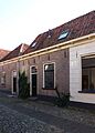
building in Elburg, Netherlands  | |||||
| Upload media | |||||
| Instance of | |||||
|---|---|---|---|---|---|
| Location | Elburg, Gelderland, Netherlands | ||||
| Street address |
| ||||
| Located on street |
| ||||
| Heritage designation |
| ||||
 | |||||
|
This is a category about rijksmonument number 14754
|
| Address |
|
Media in category "Hondegatsteeg 6, Elburg"
The following 3 files are in this category, out of 3 total.
-
 Elburg - Hondegatsteeg 6 RM14754.JPG 3,027 × 4,230; 2.56 MB
-
 Gevel - Elburg - 20069018 - RCE.jpg 806 × 1,200; 207 KB
-
 Gevels - Elburg - 20069019 - RCE.jpg 816 × 1,200; 198 KB

