Category:Hohenbergturm
Jump to navigation
Jump to search
| Object location | | View all coordinates using: OpenStreetMap |
|---|
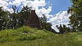
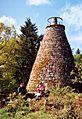
observation tower on Hohenberg mountain near Annweiler am Trifels  | |||||
| Upload media | |||||
| Instance of | |||||
|---|---|---|---|---|---|
| Named after | |||||
| Made from material | |||||
| Location | Annweiler am Trifels, Südliche Weinstraße, Rhineland-Palatinate, Germany | ||||
| Height |
| ||||
 | |||||
Media in category "Hohenbergturm"
The following 9 files are in this category, out of 9 total.
-
 2019 Pfälzerwald 020 Hohenbergturm.jpg 4,032 × 2,268; 4.71 MB
-
 2019 Pfälzerwald 021 Hohenbergturm.jpg 2,256 × 4,032; 3.73 MB
-
 2019 Pfälzerwald 023 Hohenbergturm.jpg 4,032 × 2,268; 4.61 MB
-
 Hohenbergturm 03.jpg 1,450 × 2,109; 331 KB
-
 Hohenbergturm 99.jpg 588 × 919; 88 KB
-
 Hohenbergturm-01.jpg 3,240 × 4,320; 4.73 MB
-
 Hohenbergturm-02.jpg 4,320 × 3,240; 5.57 MB
-
 Hohenbergturm-03.jpg 4,320 × 3,240; 4.15 MB
-
 Hohenbergturm.jpg 4,288 × 2,848; 3.67 MB


