Category:Hogendiekbrück (Steinkirchen)
Jump to navigation
Jump to search
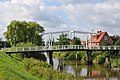
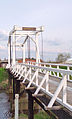
English: The Hogendiekbrück (High Dike Bridge) over the Lühe connects its western bank in Steinkirchen with its eastern bank in Höhen, a locality of the village of Borstel, which itself is part of the Jork municipality.
pedestrian bridge in Steinkirchen, Germany  | |||||
| Upload media | |||||
| Instance of | |||||
|---|---|---|---|---|---|
| Location | Steinkirchen, Lühe, Stade, Lower Saxony, Germany | ||||
 | |||||
Media in category "Hogendiekbrück (Steinkirchen)"
The following 16 files are in this category, out of 16 total.
-
 2008 Altes Land IMG 5406 DxO.jpg 1,024 × 682; 148 KB
-
 Altes Land IMG 2613 DxO.jpg 1,024 × 682; 136 KB
-
 Altes Land IMG 2616 DxO.jpg 1,024 × 682; 125 KB
-
 Hogendiekbrück IMG 5406.jpg 960 × 640; 124 KB
-
 Hogendiekbrück.Steinkirchen.1.JPG 3,872 × 2,592; 1.97 MB
-
 Hogendiekbrücke-08082012.JPG 4,288 × 2,848; 3.05 MB
-
 Hogendiekbrücke.JPG 4,608 × 3,456; 1.85 MB
-
 Hogendiekbrücken N1.jpg 4,752 × 3,168; 5.64 MB
-
 Hogendiekbrücken N2.jpg 4,752 × 3,168; 5.22 MB
-
 Hogendiekbrücken S1.jpg 4,752 × 3,168; 5.14 MB
-
 Hogendiekbrücken S2.jpg 4,752 × 3,168; 4.79 MB
-
 Neue Hogendiekbrücke 1.jpg 4,752 × 3,168; 5.05 MB
-
 Neue Hogendiekbrücke 2.jpg 4,752 × 3,168; 4.24 MB
-
 Steinkirchen Brücke.jpg 956 × 1,580; 303 KB
-
 Steinkirchen Hogendiekbrück 1.jpg 2,048 × 1,536; 1,003 KB
-
 Steinkirchen Hogendiekbrück 2.jpg 2,816 × 2,112; 1.23 MB


