Category:Hoge Gouwe 147, Gouda
Jump to navigation
Jump to search
| Object location | | View all coordinates using: OpenStreetMap |
|---|
 | |||||
| Upload media | |||||
| Instance of |
| ||||
|---|---|---|---|---|---|
| Location | Gouda, South Holland, Netherlands | ||||
| Street address |
| ||||
| Located on street |
| ||||
| Heritage designation |
| ||||
 | |||||
|
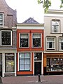
This is a category about rijksmonument number 16773
|
| Address |
|
Media in category "Hoge Gouwe 147, Gouda"
The following 2 files are in this category, out of 2 total.
-
 Hoge Gouwe 147 Gouda.jpg 1,368 × 1,824; 520 KB
-
 Voorgevel - Gouda - 20082325 - RCE.jpg 2,224 × 3,326; 1.12 MB
