Category:Hoffnungskirche (Spreenhagen)
Jump to navigation
Jump to search
| Object location | | View all coordinates using: OpenStreetMap |
|---|
church building in Brandenburg state, Germany  | |||||
| Upload media | |||||
| Instance of | |||||
|---|---|---|---|---|---|
| Location | Hartmannsdorf, Spreenhagen, Oder-Spree District, Brandenburg, Germany | ||||
| Street address |
| ||||
| Inception |
| ||||
 | |||||
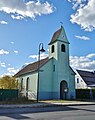
Deutsch: Bilder der Hoffnungskirche in Neu-Hartmannsdorf , Gemeinde Spreenhagen , Landkreis Oder-Spree , Land Brandenburg, Deutschland.
English: Pictures of the church in Neu-Hartmannsdorf , Spreenhagen municipality , Oder-Spree district, Brandenburg state, Germany
Français : Photos de l'église à Neu-Hartmannsdorf , commune de Spreenhagen , arrondissement de Oder-Spree , état fédéral de Brandebourg, Allemagne
Subcategories
This category has only the following subcategory.
Media in category "Hoffnungskirche (Spreenhagen)"
The following 11 files are in this category, out of 11 total.
-
 Hartmannsdorf - Honigkirche - panoramio.jpg 640 × 480; 74 KB
-
 Hoffnungskirche Neu Hartmannsdorf.jpg 3,456 × 2,876; 3.09 MB
-
 Hoffnungskirche Neu-Hartmannsdorf 2018 ENE.jpg 3,309 × 4,185; 4.86 MB
-
 Hoffnungskirche Neu-Hartmannsdorf 2018 Portal.jpg 3,608 × 4,834; 5.75 MB
-
 Hoffnungskirche Neu-Hartmannsdorf 2018 WNW.jpg 4,015 × 3,072; 3.84 MB
-
 Honigkirche in Neu Hartmannsdorf (Spreenhagen) (2).jpg 4,208 × 3,220; 2.26 MB
-
 Honigkirche in Neu Hartmannsdorf (Spreenhagen) (3).jpg 4,608 × 3,456; 1.04 MB
-
 Honigkirche in Neu Hartmannsdorf (Spreenhagen) (4).jpg 4,608 × 3,456; 1.82 MB
-
 Neu Hartmannsdorf (2).jpg 4,032 × 3,024; 2.35 MB
-
 Neu Hartmannsdorf (3).jpg 3,024 × 4,032; 3.34 MB
-
 Neu Hartmannsdorf (4).jpg 3,024 × 4,032; 2.22 MB


_(2).jpg)
_(3).jpg)
_(4).jpg)
.jpg)
.jpg)
.jpg)