Category:Historical maps of the County of Kłodzko
Jump to navigation
Jump to search
Deutsch: Historische Landkarten der Grafschaft Glatz (polnisch: Hrabstwo kłodzkie) in Schlesien.
English: Historical maps of the County of Kłodzko (german Grafschaft Glatz, polish Hrabstwo kłodzkie) in Silesia.
Media in category "Historical maps of the County of Kłodzko"
The following 10 files are in this category, out of 10 total.
-
 1930 Graftschaft Glatz.jpg 1,200 × 1,311; 766 KB
-
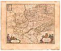 Blaeu 1645 - Comitatus Glatz.jpg 3,720 × 3,120; 1.35 MB
-
 County of Kladsko map.jpg 1,794 × 1,748; 1.08 MB
-
 Die souveraine Grafschaft Glatz Detail.jpg 771 × 650; 268 KB
-
 Die souveraine Grafschaft Glatz.jpg 850 × 650; 224 KB
-
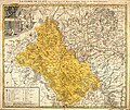 Glatzer Land Karte 1747.jpg 4,137 × 3,491; 6.35 MB
-
 HRR 1648 Glatz.PNG 1,973 × 1,513; 529 KB
-
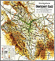
 Koarte der Grofschoaft Glootz.png 971 × 935; 228 KB
-
 Map Railway Scinawka Tlumaczow 1930.png 644 × 559; 982 KB
-
 Treti republika a Kladsko.png 1,255 × 634; 73 KB


