Category:Historic standardized SVG county maps of Arizona
Jump to navigation
Jump to search
Media in category "Historic standardized SVG county maps of Arizona"
The following 4 files are in this category, out of 4 total.
-
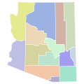
 Arizona (1891–1895) county map, cb 500k.svg 744 × 744; 159 KB
-
 Arizona (1895–1899) county map, cb 500k.svg 744 × 744; 156 KB
-
 Arizona (1899–1909) county map, cb 500k.svg 744 × 744; 156 KB
-
 Arizona (1909–1983) county map, cb 500k.svg 744 × 744; 151 KB
_county_map,_cb_500k.svg)
_county_map,_cb_500k.svg)
_county_map,_cb_500k.svg)
_county_map,_cb_500k.svg)