Category:Hip Tin Temple, Lei Yue Mun
Jump to navigation
Jump to search
| Object location | | View all coordinates using: OpenStreetMap |
|---|
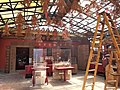
English: The Hip Tin Temple is adjacent to the Tin Hau Temple and was added after 1953.
Media in category "Hip Tin Temple, Lei Yue Mun"
The following 9 files are in this category, out of 9 total.
-
 20130219 LYM 37.JPG 3,264 × 2,176; 2.43 MB
-
 HK Lei Yue Mun Tin Hau Temple 鯉魚門 天后宮 LYM February 2021 SS2 05.jpg 4,128 × 3,096; 4.09 MB
-
 HK Lei Yue Mun Tin Hau Temple 鯉魚門 天后宮 LYM February 2021 SS2 12.jpg 2,576 × 1,932; 1.04 MB
-
 HK Lei Yue Mun Tin Hau Temple 鯉魚門 天后宮 LYM February 2021 SS2 16.jpg 4,128 × 3,096; 3.83 MB
-
 HK Lei Yue Mun Tin Hau Temple 鯉魚門 天后宮 SPK Nov-2013 signs.jpg 2,048 × 1,536; 741 KB
-
 Lei Yue Mun Kowloon Tin Hau Temple2.JPG 3,264 × 2,448; 1.83 MB
-
 Tin Hau Temple, Lei Yue Mun 04.jpg 4,514 × 3,386; 2.59 MB
-
 Tin Hau Temple, Lei Yue Mun 05.jpg 4,504 × 3,378; 2.85 MB
-
 Tin Hau Temple, Lei Yue Mun 06.jpg 4,576 × 3,432; 2.67 MB


