Category:Higher New Bridge, River Tamar
Jump to navigation
Jump to search
| Object location | | View all coordinates using: OpenStreetMap |
|---|
road bridge over River Tamar  | |||||
| Upload media | |||||
| Instance of | |||||
|---|---|---|---|---|---|
| Location |
| ||||
| Crosses | |||||
| Heritage designation |
| ||||
 | |||||
|
This is a category about scheduled monument number 1020635. |
This is a category about listed building number 1327996. |
Media in category "Higher New Bridge, River Tamar"
The following 6 files are in this category, out of 6 total.
-
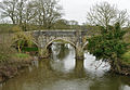
 Higher New Bridge - geograph.org.uk - 2834866.jpg 640 × 448; 67 KB
-
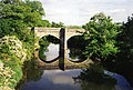
 Higher New Bridge - geograph.org.uk - 3708634.jpg 640 × 480; 101 KB
-

-
 Higher New Bridge, River Tamar.jpg 3,680 × 2,552; 3.5 MB
-

-


Categories:
- 1500s architecture in England
- 1500s bridges in the United Kingdom
- 16th-century architecture in Cornwall
- 16th-century architecture in Devon
- Bridges completed in 1504
- Bridges over the River Tamar
- Built in England in 1504
- Grade I listed bridges in Cornwall
- Grade I listed bridges in Devon
- Road bridges in Cornwall
- Road bridges in Devon
- St Stephens by Launceston Rural
- St Giles on the Heath
- Scheduled Ancient Monuments in Cornwall
- Stone arch bridges in Cornwall
- Stone arch bridges in Devon