Category:Heveningham
Jump to navigation
Jump to search
English: Heveningham is a village and civil parish in the Suffolk Coastal district of Suffolk in eastern England. Located four miles south-west of Halesworth, in 2005 it had a population of 120.
village in Suffolk, UK  | |||||
| Upload media | |||||
| Instance of | |||||
|---|---|---|---|---|---|
| Location |
| ||||
| Population |
| ||||
| Said to be the same as | Heveningham (Wikimedia duplicated page, civil parish) | ||||
 | |||||
Subcategories
This category has the following 4 subcategories, out of 4 total.
Media in category "Heveningham"
The following 164 files are in this category, out of 164 total.
-
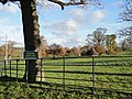
 Access road to Heveningham Hall, Suffolk - geograph.org.uk - 2898385.jpg 1,600 × 866; 295 KB
-
 Across The Field - geograph.org.uk - 4383032.jpg 1,024 × 768; 213 KB
-
-
 B1117 Halesworth Road, Heveningham - geograph.org.uk - 4384364.jpg 3,072 × 2,242; 2.16 MB
-
 B1117 Laxfield Road, Heveningham - geograph.org.uk - 4457924.jpg 3,072 × 2,304; 2.03 MB
-
 Barell's Hill ^ Bridge - geograph.org.uk - 4459512.jpg 3,072 × 2,304; 1.81 MB
-
 Barell's Hill, Heveningham - geograph.org.uk - 4459515.jpg 3,072 × 2,304; 1.55 MB
-
 Barn ^ building site at Whitehouse Farm - geograph.org.uk - 4252928.jpg 3,072 × 2,304; 1.72 MB
-
 Barn ^ building site at Whitehouse Farm - geograph.org.uk - 4252930.jpg 3,072 × 2,304; 2.13 MB
-

-
 Churchyard path to the B1117 Church Road - geograph.org.uk - 4459495.jpg 2,304 × 3,072; 3.94 MB
-
 Churchyard path to the B1117 Church Road - geograph.org.uk - 4459498.jpg 2,304 × 3,072; 3.73 MB
-
 Construction signs at White House Farm - geograph.org.uk - 4749913.jpg 3,072 × 2,304; 1.91 MB
-
 Construction Site Address at White House Farm - geograph.org.uk - 4749921.jpg 3,007 × 2,253; 1.7 MB
-
 Construction site at White House Farm - geograph.org.uk - 4749905.jpg 3,072 × 2,304; 1.82 MB
-
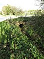 Culvert under Heveningham Long Lane - geograph.org.uk - 4458181.jpg 2,304 × 3,072; 3.2 MB
-
 Cut Mark Heveningham Village School - geograph.org.uk - 5465763.jpg 2,231 × 2,231; 3.64 MB
-
 Driveway out of Moat Farm, Heveningham - geograph.org.uk - 2197267.jpg 700 × 525; 200 KB
-
 Dunwich Lane - geograph.org.uk - 4383041.jpg 1,024 × 768; 259 KB
-
 Dunwich Lane, Heveningham - geograph.org.uk - 2653947.jpg 2,304 × 3,072; 1.63 MB
-
 Dunwich Lane, Heveningham - geograph.org.uk - 2653976.jpg 3,072 × 2,304; 1.42 MB
-
 Dunwich Lane, Heveningham - geograph.org.uk - 2653989.jpg 3,072 × 2,304; 1.35 MB
-
 Entrance to Brick Kiln Farm, Heveningham - geograph.org.uk - 2197310.jpg 700 × 525; 255 KB
-
 Entrance to Moat Farm - geograph.org.uk - 2198585.jpg 3,072 × 2,304; 1.49 MB
-

-
 Farmyard at Moat Farm, Heveningham - geograph.org.uk - 2197260.jpg 700 × 525; 325 KB
-
 Field entrance off Heveningham Long Lane - geograph.org.uk - 4458094.jpg 2,240 × 2,978; 3.34 MB
-
 Field entrance off Heveningham Long Lane - geograph.org.uk - 4458184.jpg 3,072 × 2,304; 1.79 MB
-
 Field entrance ^ footpath - geograph.org.uk - 4457938.jpg 3,072 × 2,304; 1.93 MB
-
 Fields ^ footpath to Heveningham Long Lane - geograph.org.uk - 4232907.jpg 3,072 × 2,304; 1.77 MB
-
 FittedResize600600-Heveningham-Post-Office-latest-1906.jpg 400 × 300; 16 KB
-
 Footpath - geograph.org.uk - 4383055.jpg 1,024 × 768; 389 KB
-
 Footpath gate of the footpath to Barell's Hill - geograph.org.uk - 4458033.jpg 2,192 × 2,914; 5.22 MB
-
 Footpath Marker at Moat Farm - geograph.org.uk - 1908421.jpg 3,072 × 2,304; 1.63 MB
-
 Footpath sign - geograph.org.uk - 4457947.jpg 2,304 × 3,072; 4.45 MB
-
 Footpath to Barell's Hill - geograph.org.uk - 4457914.jpg 3,072 × 2,304; 1.83 MB
-
 Footpath to Barell's Hill - geograph.org.uk - 4457917.jpg 3,072 × 2,304; 1.87 MB
-
 Footpath to Barell's Hill - geograph.org.uk - 4458142.jpg 3,072 × 2,304; 1.91 MB
-
 Footpath to Barell's Hill - geograph.org.uk - 4458148.jpg 3,072 × 2,304; 1.92 MB
-
 Footpath to Church Road, Heveningham - geograph.org.uk - 2653935.jpg 3,072 × 2,304; 1.68 MB
-
 Footpath to Church Road, Heveningham - geograph.org.uk - 2653936.jpg 2,304 × 3,072; 1.37 MB
-
 Footpath to Church Road, Heveningham - geograph.org.uk - 2653938.jpg 3,072 × 2,304; 1.32 MB
-
 Footpath to Dunwich Lane - geograph.org.uk - 2198575.jpg 2,304 × 3,072; 1.36 MB
-
 Footpath to Dunwich ^ Heveningham Long Lanes - geograph.org.uk - 4459510.jpg 2,304 × 3,072; 3.83 MB
-
 Footpath to Heveningham Long Lane - geograph.org.uk - 2777180.jpg 2,304 × 3,072; 1.54 MB
-
 Footpath to Heveningham Long Lane ^ Dunwich Lane - geograph.org.uk - 1907634.jpg 3,072 × 2,304; 1.5 MB
-
 Footpath to Hubbard's Hill ^ entrance to Wood Farm - geograph.org.uk - 2777194.jpg 3,072 × 2,304; 1.41 MB
-
 Footpath to Low Grange Farm - geograph.org.uk - 1908736.jpg 3,072 × 2,304; 1.47 MB
-
 Footpath to Low Grange Farm - geograph.org.uk - 2198591.jpg 3,072 × 2,304; 1.44 MB
-
 Footpath to Low Grange ^ Hill Farms - geograph.org.uk - 2198579.jpg 3,072 × 2,304; 1.38 MB
-
 Footpath to the B1117 Church Road - geograph.org.uk - 2198580.jpg 3,072 × 2,304; 1.44 MB
-
 Footpath to the B1117 Church Road - geograph.org.uk - 4459455.jpg 3,072 × 2,304; 1.99 MB
-
 Footpath to the B1117 Church Road - geograph.org.uk - 4459499.jpg 3,072 × 2,304; 2 MB
-
 Footpath to Ubbeston Hall - geograph.org.uk - 2805059.jpg 3,072 × 2,304; 1.35 MB
-
 Footpath to Ubbeston Hall - geograph.org.uk - 2805065.jpg 3,072 × 2,304; 1.4 MB
-
 Footpath ^ entrance to Low Grange Farm - geograph.org.uk - 2198576.jpg 3,072 × 2,304; 1.5 MB
-
 Footpaths - geograph.org.uk - 4383094.jpg 1,024 × 768; 278 KB
-
 Grove Farm - geograph.org.uk - 4383046.jpg 1,024 × 768; 135 KB
-
 Grove Farm sign - geograph.org.uk - 2653957.jpg 3,072 × 2,304; 1.39 MB
-
 Halesworth Road past Heveningham Hall - geograph.org.uk - 1930865.jpg 640 × 480; 131 KB
-
 Heveningham House Gates - geograph.org.uk - 1907632.jpg 2,304 × 3,072; 1.5 MB
-
 Heveningham Long Lane - geograph.org.uk - 2198584.jpg 3,072 × 2,304; 1.52 MB
-
 Heveningham Long Lane - geograph.org.uk - 5465770.jpg 3,512 × 3,092; 5.71 MB
-
 Heveningham Long Lane, Heveningham - geograph.org.uk - 1909082.jpg 3,072 × 2,304; 1.39 MB
-
 Heveningham Long Lane, Heveningham - geograph.org.uk - 4384371.jpg 3,072 × 2,304; 1.86 MB
-
 Heveningham Long Lane, Heveningham - geograph.org.uk - 4458102.jpg 3,072 × 2,304; 1.89 MB
-
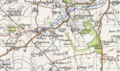 Heveningham map.PNG 646 × 382; 624 KB
-
 Heveningham Village Pump - geograph.org.uk - 4459462.jpg 2,304 × 3,072; 3.27 MB
-
 Heveningham village pump - geograph.org.uk - 6640266.jpg 4,608 × 3,072; 6.22 MB
-
 Heveningham Village Pump ^ footpath sign - geograph.org.uk - 4459459.jpg 2,304 × 3,072; 3.8 MB
-
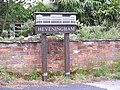 Heveningham Village Sign - geograph.org.uk - 1907534.jpg 3,072 × 2,304; 1.49 MB
-
 Heveningham village sign - geograph.org.uk - 6641116.jpg 4,608 × 3,072; 6.22 MB
-
 Heveningham village sign - geograph.org.uk - 6641117.jpg 4,608 × 3,072; 6.27 MB
-
 Heveningham, Brick Kiln Farm - geograph.org.uk - 6554376.jpg 7,445 × 4,963; 7.43 MB
-
 Heveningham, Cereal crop - geograph.org.uk - 6554405.jpg 6,607 × 4,405; 6.2 MB
-
 Heveningham, Cereal crop - geograph.org.uk - 6554406.jpg 6,405 × 4,270; 6.4 MB
-
 Heveningham, Entrance gates to Heveningham House - geograph.org.uk - 6554368.jpg 5,615 × 3,744; 7.25 MB
-

-

-
 Heveningham, Grove Farm - geograph.org.uk - 6554074.jpg 6,772 × 4,514; 7.21 MB
-
 Heveningham, Home Farm - geograph.org.uk - 6554399.jpg 6,661 × 4,440; 6.99 MB
-
 Heveningham, Home Farm, Cereal crop - geograph.org.uk - 6554396.jpg 5,839 × 3,892; 5.8 MB
-
 Heveningham, House and workshop on the B1117 - geograph.org.uk - 6554341.jpg 6,837 × 4,557; 6.01 MB
-
 Heveningham, Houses in The Street - geograph.org.uk - 6554356.jpg 5,515 × 3,676; 5.67 MB
-
 Heveningham, Private woodland - geograph.org.uk - 6554401.jpg 4,877 × 3,252; 6.61 MB
-
 Heveningham, Private woodland - geograph.org.uk - 6554402.jpg 4,816 × 3,210; 6.82 MB
-
 Heveningham, Public footpath through Wood Farm - geograph.org.uk - 6554410.jpg 5,358 × 3,572; 6.75 MB
-

-
 Heveningham, St. Margaret's Church, Eastern aspect - geograph.org.uk - 6554347.jpg 5,880 × 3,920; 7.23 MB
-
 Heveningham, St. Margaret's Church, North western aspect - geograph.org.uk - 6554351.jpg 7,514 × 5,009; 7.27 MB
-
 Heveningham, St. Margaret's Church, Western aspect - geograph.org.uk - 6554361.jpg 6,453 × 4,302; 6.82 MB
-

-
 Heveningham, Tall hedged field boundary - geograph.org.uk - 6554404.jpg 6,318 × 4,212; 5.93 MB
-
 Heveningham, Track to 'Cock's Hill' - geograph.org.uk - 6554379.jpg 6,118 × 4,079; 5.84 MB
-
 Heveningham, Two houses and part of a third on the B1117 - geograph.org.uk - 6554343.jpg 6,744 × 4,496; 6.76 MB
-
 Heveningham, Watt's Roadway, southern entrance to Home Farm - geograph.org.uk - 6554414.jpg 5,836 × 3,890; 5.37 MB
-
 Holmes Hill, Peasenhall - geograph.org.uk - 1744158.jpg 3,072 × 2,304; 1.42 MB
-
 Home Farm, Heveningham sign - geograph.org.uk - 2653984.jpg 3,072 × 2,304; 1.49 MB
-
 Lodge Wood - geograph.org.uk - 834682.jpg 640 × 480; 43 KB
-

-
 Looking towards The Street - geograph.org.uk - 4459489.jpg 3,072 × 2,304; 1.93 MB
-
 Moat at Moat Farm - geograph.org.uk - 1908406.jpg 2,304 × 3,072; 1.65 MB
-
 Moat at Moat Farm - geograph.org.uk - 1908407.jpg 3,072 × 2,304; 1.69 MB
-
 Moat at Moat Farm - geograph.org.uk - 1908419.jpg 2,304 × 3,072; 1.66 MB
-
 Moat Farm - geograph.org.uk - 1907681.jpg 3,072 × 2,304; 1.31 MB
-
 Moat ^ Moat Farmhouse - geograph.org.uk - 1908393.jpg 3,072 × 2,304; 1.68 MB
-

-

-
 Open Fields - geograph.org.uk - 4383062.jpg 1,024 × 768; 174 KB
-
 Path to The Street - geograph.org.uk - 4459478.jpg 2,304 × 3,072; 3.36 MB
-
 Pheasant Feeder ^ Footpath Marker - geograph.org.uk - 1908431.jpg 3,072 × 2,304; 1.5 MB
-
 Red Barn Farm - geograph.org.uk - 1911474.jpg 3,072 × 2,304; 1.38 MB
-
 Road Junction - geograph.org.uk - 4383103.jpg 1,024 × 768; 190 KB
-
 Road near Willow Farm, Heveningham - geograph.org.uk - 2197270.jpg 700 × 525; 209 KB
-
 Road Sign at Ubbaston - geograph.org.uk - 245012.jpg 1,600 × 1,200; 649 KB
-
 Roadsign on Heveningham Long Lane - geograph.org.uk - 1406517.jpg 3,072 × 2,304; 1.65 MB
-
 Roadsign on Heveningham Long Lane - geograph.org.uk - 1406528.jpg 3,072 × 2,304; 1.69 MB
-
 Roadsign on Heveningham Long Lane - geograph.org.uk - 1744152.jpg 3,072 × 2,304; 1.29 MB
-
 Roadsign on the B1117 Laxfield Road - geograph.org.uk - 4458084.jpg 2,253 × 2,995; 1.92 MB
-
 Roadway to Home Farm - geograph.org.uk - 2237078.jpg 640 × 480; 154 KB
-
 Rooks on a pine tree - geograph.org.uk - 2198577.jpg 700 × 525; 195 KB
-
 St Margaret's church, Heveningham - geograph.org.uk - 6065106.jpg 4,032 × 2,268; 4.33 MB
-
 St.Mary's Church Notice Board - geograph.org.uk - 4459503.jpg 2,216 × 2,947; 3.6 MB
-
 Start of the Footpath at Moat Farm - geograph.org.uk - 1908442.jpg 3,072 × 2,304; 1.26 MB
-
 Telephone number on the gate - geograph.org.uk - 4457942.jpg 2,995 × 2,244; 2.89 MB
-
 Temple Covert - geograph.org.uk - 2761992.jpg 3,072 × 2,304; 1.4 MB
-
 Temple Covert - geograph.org.uk - 834677.jpg 640 × 480; 47 KB
-
 Thatch Cottage in Dunwich Lane - geograph.org.uk - 2197317.jpg 700 × 525; 296 KB
-
 The B1117 - geograph.org.uk - 2805063.jpg 3,072 × 2,304; 1.37 MB
-
 The entrance to Grove Farm - geograph.org.uk - 2653954.jpg 3,072 × 2,304; 1.31 MB
-
 The Street Heveningham ^ The Street Postbox - geograph.org.uk - 1907486.jpg 3,072 × 2,304; 1.47 MB
-
 The Street Postbox - geograph.org.uk - 1907497.jpg 2,304 × 3,072; 1.56 MB
-
 The Street Postbox ^ Telephone Box - geograph.org.uk - 1907502.jpg 2,304 × 3,072; 1.54 MB
-
 The Street ^ Heveningham Village Sign - geograph.org.uk - 1907537.jpg 3,072 × 2,304; 1.41 MB
-
 The Street, Heveningham - geograph.org.uk - 1907525.jpg 2,304 × 3,072; 1.28 MB
-
 The Street, Heveningham - geograph.org.uk - 1907545.jpg 3,072 × 2,304; 1.39 MB
-
 The Street, Heveningham - geograph.org.uk - 5210061.jpg 4,000 × 3,000; 7.45 MB
-
 Track And Path - geograph.org.uk - 4383071.jpg 768 × 1,024; 369 KB
-
 Track to Thomas's Covert - geograph.org.uk - 2761988.jpg 3,072 × 2,304; 1.44 MB
-
 Watt's Roadway - geograph.org.uk - 2761993.jpg 3,072 × 2,304; 1.31 MB
-
 Watt's Roadway, Heveningham - geograph.org.uk - 2653981.jpg 3,072 × 2,304; 1.39 MB
-
 Wheat Crop at Moat Farm - geograph.org.uk - 1908441.jpg 3,072 × 2,304; 1.58 MB
-
 Wheat Crop at Moat Farm - geograph.org.uk - 1908643.jpg 3,072 × 2,304; 1.48 MB
-
 Whitehouse Farm, Heveningham, Suffolk - geograph.org.uk - 2898402.jpg 800 × 543; 161 KB
-

-
 B1117 Between Cock's Hill and Brick Kiln Farm - geograph.org.uk - 245287.jpg 1,600 × 1,200; 384 KB
-
 Dunwich Lane - geograph.org.uk - 1406510.jpg 3,072 × 2,304; 1.41 MB
-
 Dunwich Lane - geograph.org.uk - 1406538.jpg 3,072 × 2,304; 1.4 MB
-
 Dunwich Lane - geograph.org.uk - 1406539.jpg 3,072 × 2,304; 1.51 MB
-
 Heveningham Long Lane - geograph.org.uk - 1406520.jpg 3,072 × 2,304; 1.32 MB
-
 Heveningham Long Lane - geograph.org.uk - 1406523.jpg 3,072 × 2,304; 1.43 MB
-
 Heveningham Long Lane - geograph.org.uk - 85417.jpg 1,600 × 1,200; 531 KB
-
 Hornes Wood - geograph.org.uk - 85803.jpg 1,600 × 1,200; 535 KB
-
 Lane near Valley Farm - geograph.org.uk - 252857.jpg 640 × 480; 91 KB
-
 Moat Farm - geograph.org.uk - 230634.jpg 640 × 480; 63 KB
-
 Part of Lodge Wood - geograph.org.uk - 85430.jpg 1,600 × 1,200; 960 KB
-
 Rear of Lodge Wood - geograph.org.uk - 85431.jpg 1,600 × 1,200; 648 KB
-
 Road Junction near St.Peter's Church - geograph.org.uk - 245295.jpg 1,600 × 1,200; 567 KB
-
 Road Junction near St.Peter's Church - geograph.org.uk - 245300.jpg 1,600 × 1,200; 504 KB
-
 Road Sign - geograph.org.uk - 245298.jpg 1,600 × 1,200; 738 KB
-
 Road Sign - geograph.org.uk - 85419.jpg 1,600 × 1,200; 557 KB
-
 Roman Road near Huntingfield High House - geograph.org.uk - 250530.jpg 1,600 × 1,200; 452 KB
-
 Woods near Manor House Farm - geograph.org.uk - 235856.jpg 1,600 × 1,200; 501 KB
-
 Woods near Willow Farm - geograph.org.uk - 240515.jpg 1,600 × 1,200; 357 KB


