Category:Het Hof (Leur)
Jump to navigation
Jump to search
| Object location | | View all coordinates using: OpenStreetMap |
|---|
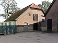
farmhouse in Wijchen, Netherlands _Rijksmonument_523586_%27t_Hof_Leurseweg_5.JPG) | |||||
| Upload media | |||||
| Instance of | |||||
|---|---|---|---|---|---|
| Part of | |||||
| Location | Leur, Wijchen, Gelderland, Netherlands | ||||
| Street address |
| ||||
| Located on street |
| ||||
| Heritage designation |
| ||||
 | |||||
|
This is a category about rijksmonumentcomplex number 523585
|
Boerderij:
|
This is a category about rijksmonument number 523586
|
Kleine schuur:
|
This is a category about rijksmonument number 523587
|
Grote schuur:
|
This is a category about rijksmonument number 523588
|
| Address |
|
Media in category "Het Hof (Leur)"
The following 3 files are in this category, out of 3 total.
-
 Leur (Wijchen) Rijksmonument 523586 't Hof Leurseweg 5.JPG 3,648 × 2,736; 4.28 MB
-
 Leur (Wijchen) Rijksmonument 523587 't Hof Leurseweg 5 kleine schuur.JPG 3,648 × 2,736; 4.1 MB
-
 Leur (Wijchen) Rijksmonument 523588 't Hof Leurseweg 5 grote schuur.JPG 3,648 × 2,736; 4.15 MB
_Rijksmonument_523587_%27t_Hof_Leurseweg_5_kleine_schuur.JPG)
_Rijksmonument_523588_%27t_Hof_Leurseweg_5_grote_schuur.JPG)