Category:Het Bannink (Deventer)
Jump to navigation
Jump to search
| Object location | | View all coordinates using: OpenStreetMap |
|---|
| Object location | | View all coordinates using: OpenStreetMap |
|---|
 | |||||
| Upload media | |||||
| Instance of | |||||
|---|---|---|---|---|---|
| Part of | |||||
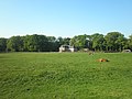
| Location | Deventer, Overijssel, Netherlands | ||||
| Street address |
| ||||
| Located on street |
| ||||
| Heritage designation |
| ||||
 | |||||
Nederlands: Het Bannink
|
This is a category about rijksmonumentcomplex number 510735
|
Landhuis
|
This is a category about rijksmonument number 510736
|
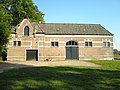
Koetshuis
|
This is a category about rijksmonument number 510737
|
| Address |
|
Media in category "Het Bannink (Deventer)"
The following 6 files are in this category, out of 6 total.
-
 Huis De Bannink bij Deventer -01.jpg 4,288 × 3,216; 2.92 MB
-
 Huis De Bannink bij Deventer -02.jpg 4,288 × 3,216; 3.07 MB
-
 Koetshuis De Achterhoek -01.jpg 4,288 × 3,216; 3.05 MB
-
 Koetshuis De Bannink bij Deventer -01.jpg 4,288 × 3,216; 2.91 MB
-
 Koetshuis De Bannink bij Deventer -02.jpg 4,288 × 3,216; 2.86 MB
-
 Overzicht voorgevel met traptoren, landhuis - Colmschate - 20350882 - RCE.jpg 1,189 × 1,200; 434 KB


