Category:Hervormde kerk (Zuidhorn)
Jump to navigation
Jump to search
| Object location | | View all coordinates using: OpenStreetMap |
|---|
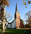
church in Westerkwartier, the Netherlands  | |||||
| Upload media | |||||
| Instance of | |||||
|---|---|---|---|---|---|
| Dedicated to | |||||
| Location | Zuidhorn, Westerkwartier, Groningen, Netherlands | ||||
| Street address |
| ||||
| Located on street |
| ||||
| Heritage designation |
| ||||
| Inception |
| ||||
| official website | |||||
 | |||||
Nederlands: Hervormde kerk
|
This is a category about rijksmonument number 41079
|
| Address |
|
Subcategories
This category has the following 2 subcategories, out of 2 total.
I
O
Media in category "Hervormde kerk (Zuidhorn)"
The following 9 files are in this category, out of 9 total.
-
 Doarpstsjerke fan Súdhorn.jpg 1,448 × 1,600; 1.57 MB
-
 Noord-oost gevel - Zuidhorn - 20225430 - RCE.jpg 1,200 × 951; 374 KB
-
 Noordgevel - Zuidhorn - 20225428 - RCE.jpg 948 × 1,200; 330 KB
-
 Zuidgevel - Zuidhorn - 20225431 - RCE.jpg 1,200 × 937; 273 KB
-
 Zuidgevel - Zuidhorn - 20225432 - RCE.jpg 1,200 × 957; 383 KB
-
 Zuidhorn - hervormde kerk - achterzijde.jpg 3,602 × 2,702; 3.42 MB
-
 Zuidhorn - hervormde kerk.jpg 4,000 × 3,000; 3.74 MB
-
 Zuidhorn Dutch Reformed Church.jpg 2,382 × 3,434; 612 KB
-
 Zuidhorn, de Hervormde kerk RM41079 foto11 2013-08-25 11.34.jpg 4,416 × 3,312; 3.14 MB


