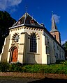
Category:Hervormde Kerk, Warffum
Jump to navigation
Jump to search
| Object location | | View all coordinates using: OpenStreetMap |
|---|
church building in Eemsmond, Netherlands  | |||||
| Upload media | |||||
| Instance of | |||||
|---|---|---|---|---|---|
| Location | Warffum, Het Hogeland, Groningen, Netherlands | ||||
| Street address |
| ||||
| Located on street |
| ||||
| Heritage designation |
| ||||
 | |||||
|
This is a category about rijksmonument number 38266
|
| Address |
|
Subcategories
This category has the following 2 subcategories, out of 2 total.
D
- De Schakel (Warffum) (3 F)
O
Media in category "Hervormde Kerk, Warffum"
The following 46 files are in this category, out of 46 total.
-
 9989 Warffum, Netherlands - panoramio (17).jpg 4,896 × 3,264; 3.24 MB
-
 Beker - Warffum - 20249487 - RCE.jpg 823 × 1,200; 153 KB
-
 Exterieur noord zijde - Warffum - 20249491 - RCE.jpg 962 × 1,200; 343 KB
-
 Exterieur noord zijde - Warffum - 20249492 - RCE.jpg 953 × 1,200; 328 KB
-
 Exterieur oost zijde - Warffum - 20249490 - RCE.jpg 971 × 1,200; 257 KB
-
 Exterieur zuid zijde - Warffum - 20249493 - RCE.jpg 1,200 × 955; 433 KB
-
 Exterieur zuid zijde - Warffum - 20249494 - RCE.jpg 1,200 × 953; 344 KB
-
 FvNWarffum1.jpg 2,160 × 3,840; 4.42 MB
-
 Geerdts - kerk van Warffum.jpg 522 × 391; 254 KB
-
 Hervormde kerk van Warffum 1.jpg 1,732 × 2,307; 919 KB
-
 Hervormde kerk van Warffum 2.jpg 1,732 × 2,307; 1.03 MB
-
 Hervormde kerk van Warffum.JPG 3,400 × 2,549; 1.77 MB
-
 Hervormde Kerk Warffum.jpg 1,824 × 1,368; 1.06 MB
-
 Hervormde Kerk Warffum2.jpg 3,324 × 2,736; 1.31 MB
-
 Hervormde Kerk Warffum3.jpg 1,824 × 1,368; 715 KB
-
 Interieur - Warffum - 20322763 - RCE.jpg 1,200 × 786; 166 KB
-
 Interieur naar het oosten - Warffum - 20249496 - RCE.jpg 969 × 1,200; 200 KB
-
 Interieur naar het oosten - Warffum - 20249497 - RCE.jpg 953 × 1,200; 163 KB
-
 Interieur naar het westen - Warffum - 20249499 - RCE.jpg 1,200 × 964; 198 KB
-
 Interieur, koorgewelf - Warffum - 20249498 - RCE.jpg 1,200 × 960; 147 KB
-
 Inwendig vanuit het noorden en vanuit het oosten - Warffum - 20249482 - RCE.jpg 844 × 1,200; 211 KB
-
 Inwendig vanuit het noorden en vanuit het oosten - Warffum - 20249483 - RCE.jpg 827 × 1,200; 191 KB
-
 Kerk vanuit het westen en vanuit het noorden - Warffum - 20249479 - RCE.jpg 838 × 1,200; 161 KB
-
 Kerk vanuit het westen en vanuit het noorden - Warffum - 20249480 - RCE.jpg 1,200 × 845; 193 KB
-
 Noordelijk dakvlak, Franse leien - Warffum - 20249504 - RCE.jpg 1,200 × 783; 184 KB
-
 Noordelijk dakvlak, Franse leien - Warffum - 20249505 - RCE.jpg 1,200 × 783; 185 KB
-
 Noordelijk dakvlak, Franse leien - Warffum - 20249506 - RCE.jpg 1,200 × 783; 174 KB
-
 Noordelijk dakvlak, Franse leien - Warffum - 20249507 - RCE.jpg 783 × 1,200; 203 KB
-
 Noordelijke dakvlak, pyriet in Franse leien - Warffum - 20249501 - RCE.jpg 1,200 × 771; 176 KB
-
 Noordelijke dakvlak, pyriet in Franse leien - Warffum - 20249502 - RCE.jpg 1,200 × 783; 175 KB
-
 Noordelijke dakvlak, pyriet in Franse leien - Warffum - 20249503 - RCE.jpg 1,200 × 783; 211 KB
-

-

-

-
 Warffum - kerk - interieur (1).jpg 6,000 × 4,000; 8.98 MB
-
 Warffum - kerk - interieur (2).jpg 3,879 × 5,819; 7.36 MB
-
 Warffum - kerk vanuit osten.jpg 4,000 × 5,000; 7.79 MB
-
 Warffum church.jpg 1,200 × 1,600; 585 KB
-
 Zuid zijde, ingang - Warffum - 20249495 - RCE.jpg 972 × 1,200; 299 KB
-
 Zuid-gevel - Warffum - 20249481 - RCE.jpg 830 × 1,200; 249 KB
-
 Zuidelijk dakvlak, pyriet in Franse leien - Warffum - 20249508 - RCE.jpg 784 × 1,200; 160 KB
-
 Zuidelijk dakvlak, pyriet in Franse leien - Warffum - 20249509 - RCE.jpg 1,200 × 783; 175 KB
-
 Zuidelijk dakvlak, pyriet in Franse leien - Warffum - 20249510 - RCE.jpg 1,200 × 783; 183 KB
-
 Zuidelijk dakvlak, pyriet in Franse leien - Warffum - 20249511 - RCE.jpg 1,200 × 783; 194 KB
-
 Zuidelijk dakvlak, pyriet in Franse leien - Warffum - 20249512 - RCE.jpg 1,200 × 783; 169 KB
-
 Zuidelijk dakvlak, pyriet in Franse leien - Warffum - 20249513 - RCE.jpg 1,200 × 783; 174 KB
.jpg)


.jpg)
.jpg)


