Category:Hervormde Kerk, Ulrum
Jump to navigation
Jump to search
| Object location | | View all coordinates using: OpenStreetMap |
|---|
church building in De Marne, Netherlands  | |||||
| Upload media | |||||
| Instance of | |||||
|---|---|---|---|---|---|
| Dedicated to | |||||
| Location | Ulrum, Het Hogeland, Groningen, Netherlands | ||||
| Street address |
| ||||
| Located on street |
| ||||
| Heritage designation |
| ||||
| Inception |
| ||||
| Significant event |
| ||||
| official website | |||||
 | |||||
|
This is a category about rijksmonument number 35863
|
| Address |
|
Media in category "Hervormde Kerk, Ulrum"
The following 28 files are in this category, out of 28 total.
-
 Avondmaalsbeker - Ulrum - 20211489 - RCE.jpg 837 × 1,200; 131 KB
-
 Bank - Ulrum - 20211491 - RCE.jpg 1,200 × 831; 228 KB
-

-
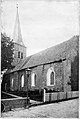 De Afscheiding van 1834 p IX Ned. Hervormde kerk te Ulrum.jpg 959 × 1,431; 413 KB
-
 De Afscheiding van 1834 p X interieur van de Ned. Hervormde kerk te Ulrum.jpg 1,503 × 1,105; 519 KB
-

-
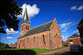
 Exterieur OVERZICHT NOORDGEVEL - Ulrum - 20271332 - RCE.jpg 955 × 1,200; 232 KB
-
 Exterieur OVERZICHT OOSTGEVEL - Ulrum - 20271333 - RCE.jpg 955 × 1,200; 268 KB
-
 Exterieur OVERZICHT ZUIDGEVEL - Ulrum - 20271331 - RCE.jpg 950 × 1,200; 323 KB
-
 Herenbank - Ulrum - 20211490 - RCE.jpg 1,200 × 827; 187 KB
-
 HVKerkUlrum.jpg 4,772 × 3,188; 2.43 MB
-
 Interieur - Ulrum - 20211493 - RCE.jpg 1,200 × 802; 270 KB
-
 Interieur - Ulrum - 20211494 - RCE.jpg 803 × 1,200; 231 KB
-
 Interieur - Ulrum - 20322814 - RCE.jpg 1,200 × 785; 152 KB
-
 Interieur, aanzicht orgel, orgelnummer 1499 - Ulrum - 20358260 - RCE.jpg 956 × 1,200; 229 KB
-
 INTERIEUR, NAAR HET NOORDEN - Ulrum - 20271339 - RCE.jpg 1,200 × 955; 285 KB
-
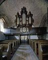
 INTERIEUR, ORGEL - Ulrum - 20271337 - RCE.jpg 1,200 × 960; 286 KB
-
 INTERIEUR, OVERZICHT NAAR HET OOSTEN - Ulrum - 20271334 - RCE.jpg 958 × 1,200; 311 KB
-
 INTERIEUR, OVERZICHT NAAR HET WESTEN - Ulrum - 20271335 - RCE.jpg 1,200 × 963; 319 KB
-
 INTERIEUR, PREEKSTOEL - Ulrum - 20271336 - RCE.jpg 951 × 1,200; 237 KB
-
 INTERIEUR, TOREN - Ulrum - 20271338 - RCE.jpg 954 × 1,200; 238 KB
-
 Inwendig naar het noord-oosten - Ulrum - 20211488 - RCE.jpg 882 × 1,200; 215 KB
-
 Inwendig naar het noord-westen - Ulrum - 20211487 - RCE.jpg 892 × 1,200; 269 KB
-
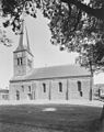
 Kerk vanuit het noord-oosten - Ulrum - 20211485 - RCE.jpg 874 × 1,200; 216 KB
-
 Kerk vanuit het zuid-westen - Ulrum - 20211483 - RCE.jpg 1,200 × 844; 203 KB
-
 NH-tsjerke Ulrum.JPG 2,448 × 3,264; 3.79 MB
-
 Orgel - Ulrum - 20211492 - RCE.jpg 810 × 1,200; 229 KB
-
 Pijler tegen zuidwand west-zijde - Ulrum - 20211486 - RCE.jpg 1,200 × 833; 192 KB


