Category:Hervormde Kerk, Tull en 't Waal
Jump to navigation
Jump to search
| Object location | | View all coordinates using: OpenStreetMap |
|---|
church in Tull en 't Waal, Netherlands  | |||||
| Upload media | |||||
| Instance of | |||||
|---|---|---|---|---|---|
| Location | Tull en 't Waal, Utrecht, Netherlands | ||||
| Street address |
| ||||
| Heritage designation |
| ||||
| Significant event |
| ||||
 | |||||
Nederlands: De N.H. kerk van Tull en ´t Waal
|
This is a category about rijksmonument number 398785
|
| Address |
|
Subcategories
This category has only the following subcategory.
B
Media in category "Hervormde Kerk, Tull en 't Waal"
The following 16 files are in this category, out of 16 total.
-
 Interieur naar het oosten - Tull en 't Waal - 20210100 - RCE.jpg 1,200 × 955; 152 KB
-
 Interieur naar het westen - Tull en 't Waal - 20210099 - RCE.jpg 1,200 × 960; 153 KB
-
 N-H kerk Tull-en-t-Waal.jpg 3,264 × 2,448; 1.89 MB
-
 Ned-Hervormde-kerk Waalseweg-71 Tull-en-'t-Waal Nederland.JPG 1,944 × 2,592; 2.93 MB
-
 Noordoostgevel - Tull en 't Waal - 20210096 - RCE.jpg 1,200 × 960; 391 KB
-
 Noordwestgevel - Tull en 't Waal - 20210095 - RCE.jpg 946 × 1,200; 365 KB
-
 TULL EN 'T WAAL HERVORMDE KERK 01.jpg 3,264 × 2,448; 7.42 MB
-
 TULL EN 'T WAAL HERVORMDE KERK 02.jpg 3,264 × 2,448; 4.93 MB
-
 TULL EN 'T WAAL HERVORMDE KERK 03.jpg 3,264 × 2,448; 6.3 MB
-
 TULL EN 'T WAAL HERVORMDE KERK 04.jpg 3,264 × 2,448; 5.31 MB
-
 TULL EN 'T WAAL HERVORMDE KERK 05.jpg 3,264 × 2,448; 7.48 MB
-
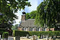 Tull en 't Waal met zicht op de Hervormde kerk.JPG 2,048 × 1,366; 1.11 MB
-
 Tull en t Waal RM Hervormde Kerk.jpg 4,272 × 3,172; 6.83 MB
-
 Waalseweg 71, Tull en 't Waal.jpg 500 × 333; 87 KB
-
 Zuidgevel - Tull en 't Waal - 20210097 - RCE.jpg 957 × 1,200; 340 KB
-
 Zuidgevel - Tull en 't Waal - 20210098 - RCE.jpg 1,200 × 959; 373 KB


