Category:Hervormde Kerk, Oosthuizen
Jump to navigation
Jump to search
| Object location | | View all coordinates using: OpenStreetMap |
|---|
church building in Zeevang, Netherlands  | |||||
| Upload media | |||||
| Instance of | |||||
|---|---|---|---|---|---|
| Named after | |||||
| Dedicated to | |||||
| Location | Oosthuizen, Edam-Volendam, North Holland, Netherlands | ||||
| Street address |
| ||||
| Located on street |
| ||||
| Has part(s) | |||||
| Heritage designation |
| ||||
| Inception |
| ||||
 | |||||
Nederlands: Hervormde Kerk - anno 1511
|
This is a category about rijksmonument number 40332
|
| Address |
|
Subcategories
This category has the following 2 subcategories, out of 2 total.
O
- Orgel Hervormde kerk Oosthuizen (13 F)
P
Media in category "Hervormde Kerk, Oosthuizen"
The following 104 files are in this category, out of 104 total.
-
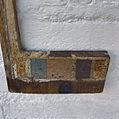
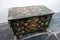 Bergkist 01, Hervormde kerk Oosthuizen.JPG 3,888 × 2,592; 3.67 MB
-
 Bergkist 02, Hervormde kerk Oosthuizen.JPG 3,888 × 2,592; 3.56 MB
-
 Detail doopboog, Hervormde kerk Oosthuizen.JPG 2,592 × 3,888; 2.19 MB
-
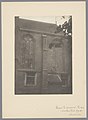 Detail van de zuidgevel van het koor van de Grote Kerk te Oosthuizen, RP-F-00-2194.jpg 1,828 × 2,500; 741 KB
-
 Dooptuin, Hervormde kerk Oosthuizen.JPG 3,888 × 2,592; 3.73 MB
-
 Edam-Volendam Oosthuizen, de Grote of Sint-Nicolaaskerk RM40332 IMG 6999 2023-06-25 14.21.jpg 5,244 × 3,432; 12.46 MB
-
 Exterieur - Oosthuizen - 20175364 - RCE.jpg 912 × 1,200; 258 KB
-
 Exterieur naar 't zuiden - Oosthuizen - 20175390 - RCE.jpg 1,200 × 959; 234 KB
-
 Exterieur naar het noorden - Oosthuizen - 20175388 - RCE.jpg 1,200 × 952; 296 KB
-
 Exterieur naar het oosten - Oosthuizen - 20175389 - RCE.jpg 1,200 × 951; 208 KB
-
 Exterieur naar het westen - Oosthuizen - 20175392 - RCE.jpg 1,200 × 955; 340 KB
-
 Exterieur naar het zuid-westen - Oosthuizen - 20175391 - RCE.jpg 1,200 × 956; 289 KB
-
 Exterieur OVERZICHT ZUIDGEVEL - Oosthuizen - 20264752 - RCE.jpg 1,200 × 773; 226 KB
-
 Gebrandschilderde glazen - Oosthuizen - 20175379 - RCE.jpg 857 × 1,200; 156 KB
-
 Gebrandschilderde glazen - Oosthuizen - 20175380 - RCE.jpg 865 × 1,200; 174 KB
-
 Gebrandschilderde glazen - Oosthuizen - 20175381 - RCE.jpg 830 × 1,200; 186 KB
-
 Geschilderd raam in het koor van de Grote Kerk te Oosthuizen, RP-F-00-2188.jpg 1,839 × 2,500; 781 KB
-
 Geschilderd raam in het schip van de Grote Kerk te Oosthuizen, RP-F-00-2190.jpg 1,833 × 2,500; 630 KB
-
 Geschilderd raam van het schip in de Grote Kerk te Oosthuizen, RP-F-00-2189.jpg 1,826 × 2,500; 689 KB
-
 Gezicht op het koor van de Grote Kerk te Oosthuizen, RP-F-00-2192.jpg 1,842 × 2,500; 766 KB
-
 Grafmonument van François van Bredehoff in de Grote Kerk te Oosthuizen, RP-F-00-2185.jpg 1,824 × 2,500; 780 KB
-

-
 Herenbank, Hervormde kerk Oosthuizen.JPG 3,888 × 2,592; 3.32 MB
-
 Hervormde kerk Oosthuizen 02.JPG 3,888 × 2,592; 4.65 MB
-
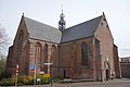 Hervormde kerk Oosthuizen.JPG 3,888 × 2,592; 4.55 MB
-
 In- en exterieur - Oosthuizen - 20175369 - RCE.jpg 953 × 1,200; 249 KB
-
 In- en exterieur - Oosthuizen - 20175370 - RCE.jpg 1,200 × 948; 320 KB
-
 INT. DEEL VAN ORGELKAS, DETAIL - Oosthuizen - 20311461 - RCE.jpg 1,195 × 1,200; 244 KB
-
 INT. DEEL VAN ORGELKAS, DETAIL - Oosthuizen - 20311462 - RCE.jpg 1,198 × 1,200; 307 KB
-
 Interieur - Oosthuizen - 20175372 - RCE.jpg 1,200 × 901; 145 KB
-
 Interieur naar het oosten - Oosthuizen - 20175394 - RCE.jpg 1,200 × 960; 178 KB
-
 Interieur naar het westen - Oosthuizen - 20175395 - RCE.jpg 959 × 1,200; 176 KB
-
 Interieur transept naar het noorden - Oosthuizen - 20175393 - RCE.jpg 1,200 × 954; 176 KB
-
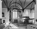
 Interieur van de Grote Kerk te Oosthuizen, RP-F-00-2193.jpg 2,500 × 1,822; 631 KB
-
 Interieur van de kerk te Oosthuizen, SK-A-3647.jpg 5,078 × 3,535; 2.76 MB
-

-

-

-

-

-

-

-

-

-

-

-

-

-

-

-

-

-
 INTERIEUR, GRAFZERK MET GEKALLIGRAFEERD OPSCHRIFT - Oosthuizen - 20287391 - RCE.jpg 1,195 × 1,200; 427 KB
-
 INTERIEUR, GRAFZERK MET GEKALLIGRAFEERD OPSCHRIFT - Oosthuizen - 20287392 - RCE.jpg 1,200 × 1,190; 398 KB
-
 INTERIEUR, GRAFZERK MET GEKALLIGRAFEERD OPSCHRIFT - Oosthuizen - 20287393 - RCE.jpg 1,195 × 1,200; 511 KB
-
 INTERIEUR, GRAFZERK MET GEKALLIGRAFEERD OPSCHRIFT - Oosthuizen - 20287394 - RCE.jpg 1,200 × 1,190; 455 KB
-
 INTERIEUR, GRAFZERK MET GEKALLIGRAFEERD OPSCHRIFT - Oosthuizen - 20287395 - RCE.jpg 1,198 × 1,200; 484 KB
-
 INTERIEUR, GRAFZERK MET GEKALLIGRAFEERD OPSCHRIFT - Oosthuizen - 20287396 - RCE.jpg 1,200 × 1,192; 510 KB
-
 INTERIEUR, GRAFZERK MET GEKALLIGRAFEERD OPSCHRIFT - Oosthuizen - 20287397 - RCE.jpg 1,195 × 1,200; 479 KB
-
 INTERIEUR, GRAFZERK MET GEKALLIGRAFEERD OPSCHRIFT - Oosthuizen - 20287398 - RCE.jpg 1,200 × 1,190; 569 KB
-
 INTERIEUR, GRAFZERK MET GEKALLIGRAFEERD OPSCHRIFT - Oosthuizen - 20287399 - RCE.jpg 1,200 × 1,199; 511 KB
-
 INTERIEUR, GRAFZERK MET GEKALLIGRAFEERD OPSCHRIFT - Oosthuizen - 20287400 - RCE.jpg 1,197 × 1,200; 466 KB
-
 INTERIEUR, GRAFZERK MET GEKALLIGRAFEERD OPSCHRIFT - Oosthuizen - 20287401 - RCE.jpg 1,200 × 1,197; 485 KB
-
 INTERIEUR, GRAFZERK MET GEKALLIGRAFEERD OPSCHRIFT - Oosthuizen - 20287402 - RCE.jpg 1,200 × 1,183; 458 KB
-
 INTERIEUR, GRAFZERK MET GEKALLIGRAFEERD OPSCHRIFT - Oosthuizen - 20287403 - RCE.jpg 1,197 × 1,200; 429 KB
-
 Inwendig naar het zuid-oosten - Oosthuizen - 20175371 - RCE.jpg 1,200 × 961; 217 KB
-
 Kapconstructie detail - Oosthuizen - 20175384 - RCE.jpg 1,200 × 951; 283 KB
-
 Kapconstructie van het koor - Oosthuizen - 20175385 - RCE.jpg 1,200 × 940; 308 KB
-
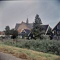
 Kerk vanuit het noord-westen - Oosthuizen - 20175365 - RCE.jpg 1,200 × 892; 297 KB
-
 Kerk vanuit het oosten - Oosthuizen - 20175367 - RCE.jpg 896 × 1,200; 214 KB
-
 Kerk vanuit het zuid-oosten - Oosthuizen - 20175363 - RCE.jpg 1,200 × 921; 283 KB
-
 Kerk vanuit het zuiden - Oosthuizen - 20175366 - RCE.jpg 1,200 × 901; 205 KB
-
 Kerkorgel in de Grote Kerk te Oosthuizen, RP-F-00-4504.jpg 4,980 × 6,694; 3.07 MB
-
 Koor vanuit het zuiden - Oosthuizen - 20175368 - RCE.jpg 891 × 1,200; 261 KB
-
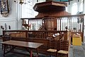
 Koorbank - Oosthuizen - 20175375 - RCE.jpg 904 × 1,200; 184 KB
-
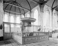
 Koorbank in de Grote Kerk te Oosthuizen, RP-F-00-2187.jpg 1,836 × 2,500; 638 KB
-
 Koorbank, Hervormde kerk Oosthuizen.JPG 2,592 × 3,888; 2.92 MB
-
 Koorhek en de preekstoel in de Grote Kerk te Oosthuizen, RP-F-00-4503.jpg 6,862 × 4,946; 3.28 MB
-
 Kroonluchter, Hervormde kerk Oosthuizen.JPG 2,592 × 3,888; 2.3 MB
-
 Oosthuizen kerk.jpg 400 × 300; 100 KB
-
 Oosthuizen, kerk foto2 2010-06-05 15.58.JPG 3,456 × 2,592; 1.77 MB
-
 Orgel en portaal in de Grote Kerk te Oosthuizen, RP-F-00-2191.jpg 1,824 × 2,500; 721 KB
-

-
-
 Overzicht zuidelijke transept, Hervormde kerk Oosthuizen.JPG 2,592 × 3,888; 2.7 MB
-
 Preekstoel - Oosthuizen - 20175374 - RCE.jpg 1,200 × 946; 182 KB
-
 Preekstoel, Hervormde kerk Oosthuizen.JPG 2,592 × 3,888; 3.36 MB
-

-
 Rouwbord Adrianus van Bredehoff.JPG 480 × 640; 91 KB
-
 Rouwbord Francois van Bredehoff junior.jpg 480 × 640; 93 KB
-
 Rouwbord Francois van Bredehoff.JPG 480 × 640; 89 KB
-
 Rouwbord in de Grote Kerk, Oosthuizen.JPG 480 × 640; 91 KB
-
 Schalkbeeld man 1, Hervormde kerk Oosthuizen.JPG 2,592 × 3,888; 2.12 MB
-
 Schalkbeeld man 2, Hervormde kerk Oosthuizen.JPG 2,592 × 3,888; 2.04 MB
-
 Schalkbeeld vrouw 1, Hervormde kerk Oosthuizen.JPG 2,592 × 3,888; 1.9 MB
-
 Schalkbeeld vrouw 2, Hervormde kerk Oosthuizen.JPG 2,592 × 3,888; 2.06 MB
-
 Verrotting van de kap aan de noord-zijde koor - Oosthuizen - 20175382 - RCE.jpg 1,200 × 942; 359 KB
-
 Verrotting van de kap aan de noord-zijde koor - Oosthuizen - 20175383 - RCE.jpg 1,200 × 947; 272 KB
-
 Voormalig koorhek en preekstoel - Oosthuizen - 20175373 - RCE.jpg 1,200 × 895; 186 KB
-
 Voormalig koorhek en preekstoel in de Grote Kerk te Oosthuizen, RP-F-00-2186.jpg 2,500 × 1,819; 736 KB
-
 Westgevel van de Grote Kerk te Oosthuizen, RP-F-00-2195.jpg 2,500 × 1,832; 938 KB
-
 Zonnewijzer Westzijde - Oosthuizen - 20175396 - RCE.jpg 775 × 1,200; 154 KB
-
 Zonnewijzer, Hervormde kerk Oosthuizen.JPG 2,592 × 3,888; 3.51 MB
-
 Zuidgevel van de Grote Kerk te Oosthuizen, RP-F-00-2196.jpg 2,500 × 1,819; 752 KB


_-_Edam_-_20300301_-_RCE.jpg)
,_DETAIL_-_Edam_-_20259798_-_RCE.jpg)
,_DETAIL_-_Edam_-_20259811_-_RCE.jpg)
,_DETAIL_A_3_-_Edam_-_20259799_-_RCE.jpg)
,_DETAIL_A_4_-_Edam_-_20259800_-_RCE.jpg)
,_DETAIL_A_5_-_Edam_-_20259801_-_RCE.jpg)
,_DETAIL_A_5_-_Edam_-_20259802_-_RCE.jpg)
,_DETAIL_B_3_-_Edam_-_20259803_-_RCE.jpg)
,_DETAIL_B_4_-_Edam_-_20259804_-_RCE.jpg)
,_DETAIL_B_5_-_Edam_-_20259805_-_RCE.jpg)
,_DETAIL_C_3_-_Edam_-_20259806_-_RCE.jpg)
,_DETAIL_C_4_-_Edam_-_20259807_-_RCE.jpg)
,_DETAIL_C_5_-_Edam_-_20259808_-_RCE.jpg)
,_DETAIL_D_3_-_Edam_-_20259809_-_RCE.jpg)
,_DETAIL_D_4_-_Edam_-_20259810_-_RCE.jpg)
,_OVERZICHT_-_Edam_-_20259796_-_RCE.jpg)
,_OVERZICHT_-_Edam_-_20259797_-_RCE.jpg)


