Category:Hervormde Kerk, Driel
Jump to navigation
Jump to search
| Object location | | View all coordinates using: OpenStreetMap |
|---|
 | |||||
| Upload media | |||||
| Instance of |
| ||||
|---|---|---|---|---|---|
| Location | Driel, Gelderland, Netherlands | ||||
| Street address |
| ||||
| Heritage designation |
| ||||
 | |||||
Kerk:
|
This is a category about rijksmonument number 21980
|
Toren:
|
This is a category about rijksmonument number 21981
|
| Address |
|
Subcategories
This category has only the following subcategory.
B
Media in category "Hervormde Kerk, Driel"
The following 25 files are in this category, out of 25 total.
-
 Avondmaalsbeker - Driel - 20064229 - RCE.jpg 956 × 1,200; 193 KB
-
 Avondmaalsbeker - Driel - 20064231 - RCE.jpg 944 × 1,200; 186 KB
-
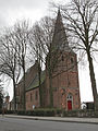
 Driel Rijksmonument 21980 NH kerk.JPG 3,648 × 2,736; 4.12 MB
-
 Driel Rijksmonument 21981 toren NH kerk.JPG 2,736 × 3,648; 3.4 MB
-
 Driel, NH kerk foto1 RM21980 2012-02-26 13.43.JPG 3,312 × 4,416; 12.36 MB
-
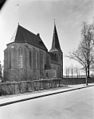
 Exterieur naar het zuid-oosten - Driel - 20064224 - RCE.jpg 951 × 1,200; 283 KB
-
 Exterieur naar het zuid-westen - Driel - 20064225 - RCE.jpg 1,200 × 956; 243 KB
-
 Ingang zuid-zijde - Driel - 20064235 - RCE.jpg 954 × 1,200; 307 KB
-
 Interieur na de brand - Driel - 20064226 - RCE.jpg 875 × 1,200; 230 KB
-
 Interieur naar het oosten - Driel - 20064227 - RCE.jpg 941 × 1,200; 166 KB
-
 Interieur naar het oosten - Driel - 20064238 - RCE.jpg 956 × 1,200; 199 KB
-
 Interieur naar het westen - Driel - 20064239 - RCE.jpg 950 × 1,200; 195 KB
-
 Koor noord-zijde - Driel - 20064233 - RCE.jpg 944 × 1,200; 297 KB
-
 Koor plafondconstructie - Driel - 20064243 - RCE.jpg 953 × 1,200; 314 KB
-
 Naar aquarel - Driel - 20064220 - RCE.jpg 1,200 × 868; 148 KB
-
 Noord-oost zijde - Driel - 20064232 - RCE.jpg 944 × 1,200; 218 KB
-
 Old protestant church of Driel in wintersunshine 8 Januari 2014 - panoramio.jpg 3,262 × 4,828; 3.34 MB
-
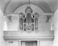 Orgel - Driel - 20064240 - RCE.jpg 1,200 × 955; 157 KB
-
 Preekstoel - Driel - 20064228 - RCE.jpg 959 × 1,200; 248 KB
-
 Preekstoel - Driel - 20064241 - RCE.jpg 951 × 1,200; 196 KB
-
 Preekstoel voet en kuip - Driel - 20064242 - RCE.jpg 956 × 1,200; 230 KB
-
 Toren - Driel - 20064221 - RCE.jpg 870 × 1,200; 242 KB
-
 Toren west-zijde detail - Driel - 20064237 - RCE.jpg 1,200 × 953; 376 KB
-
 West-zijde - Driel - 20064236 - RCE.jpg 955 × 1,200; 240 KB
-
 Zilveren avondmaalsschotel - Driel - 20064230 - RCE.jpg 948 × 1,200; 269 KB


