Category:Hervormde Kerk, Callantsoog
Jump to navigation
Jump to search
| Object location | | View all coordinates using: OpenStreetMap |
|---|
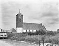
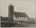
church building in Schagen, Netherlands  | |||||
| Upload media | |||||
| Instance of | |||||
|---|---|---|---|---|---|
| Location | Callantsoog, North Holland, Netherlands | ||||
| Street address |
| ||||
| Located on street |
| ||||
| Heritage designation |
| ||||
| Inception |
| ||||
 | |||||
Kerk:
|
This is a category about rijksmonument number 11461
|
Toren:
|
This is a category about rijksmonument number 11462
|
| Address |
|
Media in category "Hervormde Kerk, Callantsoog"
The following 30 files are in this category, out of 30 total.
-
 2024 Tsjerke fan Callantsoog.jpg 1,600 × 1,599; 873 KB
-
 Callantsoog - Nederlands Hervormde Kerk - Herdenkingsplaat 1.jpg 3,785 × 2,523; 4.52 MB
-
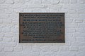 Callantsoog - Nederlands Hervormde Kerk - Herdenkingsplaat 2.jpg 3,801 × 2,534; 5.31 MB
-
 Callantsoog - Nederlands Hervormde Kerk - zicht op de zuidoostkant.jpg 3,701 × 2,467; 5.73 MB
-
 Callantsoog Hervormde Kerk 2009.jpg 2,304 × 3,072; 1.53 MB
-
 Callantsoog kerk.jpg 2,592 × 3,166; 4.98 MB
-

-
 Exterieur - Callantsoog - 20046433 - RCE.jpg 1,200 × 950; 208 KB
-
 Exterieur - Callantsoog - 20046434 - RCE.jpg 1,200 × 950; 221 KB
-
 Exterieur - Callantsoog - 20046435 - RCE.jpg 1,200 × 964; 245 KB
-
 Exterieur naar het oosten - Callantsoog - 20046428 - RCE.jpg 888 × 1,200; 257 KB
-
 Exterieur naar het westen - Callantsoog - 20046429 - RCE.jpg 888 × 1,200; 260 KB
-

-
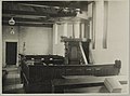
 Interieur - Callantsoog - 20323372 - RCE.jpg 1,200 × 887; 135 KB
-
 Interieur - Callantsoog - 20323373 - RCE.jpg 1,200 × 893; 123 KB
-
 Interieur - Callantsoog - 20323374 - RCE.jpg 889 × 1,200; 127 KB
-
 Interieur naar het oosten - Callantsoog - 20046431 - RCE.jpg 1,200 × 900; 189 KB
-
 Interieur naar het oosten - Callantsoog - 20046436 - RCE.jpg 1,200 × 946; 162 KB
-
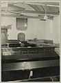
 Interieur naar het zuiden (met preekstoel) - Callantsoog - 20046430 - RCE.jpg 890 × 1,200; 176 KB
-
 Kerk van Callantsoog.jpg 3,072 × 2,304; 1.83 MB
-
 KerkCallantsoog.jpg 2,400 × 1,800; 720 KB
-
 Overzicht vanuit het noordoosten - Callantsoog - 20325893 - RCE.jpg 1,200 × 896; 102 KB
-
 Overzicht vanuit het zuidoosten - Callantsoog - 20323284 - RCE.jpg 1,200 × 895; 119 KB
-
 Overzicht vanuit het zuidwesten - Callantsoog - 20323369 - RCE.jpg 1,200 × 915; 112 KB
-
 Overzicht vanuit het zuidwesten - Callantsoog - 20325754 - RCE.jpg 898 × 1,200; 84 KB
-

-
 Overzicht zuidoostgevel - Callantsoog - 20396472 - RCE.jpg 1,200 × 1,200; 272 KB
-
 Zicht vanuit het noordoosten - Callantsoog - 20323371 - RCE.jpg 2,608 × 1,925; 555 KB
-
 Zicht vanuit het zuiden - Callantsoog - 20323370 - RCE.jpg 2,516 × 1,928; 585 KB
-
 Zuidzijde - Callantsoog - 20322661 - RCE.jpg 1,200 × 914; 125 KB


_-_Callantsoog_-_20046430_-_RCE.jpg)


